ممر گوتارد
| ممر گوتارد | |
|---|---|
| إيطالية: Passo del San Gottardo ألمانية: Gotthardpass إنگليزية: Gotthard Pass | |
 Gotthard's Hospice and Museum | |
| الارتفاع | 2٬106 م (6٬909 ق) |
| يمر بأرجائه | 2 |
| الموقع | Canton of Ticino, سويسرا (close to canton of Uri) |
| السلسلة | Lepontine Alps |
| الإحداثيات | 46°33′22.5″N 8°34′04″E / 46.556250°N 8.56778°E |
| الخريطة الطبوغرافية | Swiss Federal Office of Topography swisstopo |
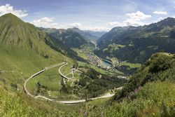
ممر گوتارد Gotthard Pass أو ممر سانت گوتارد (إيطالية: Passo del San Gottardo, ألمانية: Gotthardpass) at 2,106 m (6,909 ft) هو ممر جبلي عبر Saint-Gotthard Massif in the Alps, connecting northern and southern Switzerland. The pass lies between Airolo in the Italian-speaking canton of Ticino, and Andermatt in the German-speaking canton of Uri, and connects further Bellinzona to Lucerne, Basel, and Zurich. The region of the Gotthard Pass is an important north-south axis in Europe and is crossed by three major traffic tunnels, each being the world's longest at the time of their construction: the Gotthard Rail Tunnel (1882), the Gotthard Road Tunnel (1980) and the Gotthard Base Tunnel (2016).
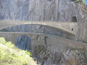
Though the pass was locally known in antiquity, it was not generally used until the early 13th century because travel involved fording the turbulent Reuss, swollen with snowmelt during the early summer, in the narrow steep-sided Schöllenen Gorge (ألمانية: Schöllenenschlucht), below Andermatt. As early as 1236, Gotthard Pass was dedicated to the Roman Catholic Saint Gotthard of Hildesheim.
. . . . . . . . . . . . . . . . . . . . . . . . . . . . . . . . . . . . . . . . . . . . . . . . . . . . . . . . . . . . . . . . . . . . . . . . . . . . . . . . . . . . . . . . . . . . . . . . . . . . . . . . . . . . . . . . . . . . . . . . . . . . . . . . . . . . . . . . . . . . . . . . . . . . . . . . . . . . . . . . . . . . . . . .
الجغرافيا
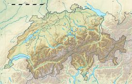
The Gotthard Pass connects the cantons of Uri (north) and Ticino (south). The pass itself is located within the latter canton, about 2 km south of the border with Uri, between the massifs of Pizzo Lucendro (west) and Pizzo Centrale (east). The pass lies on the most important route between the southern canton of Ticino and central Switzerland as well as most of the northern part of the country. It is the most direct link between Zürich and Lugano and also between some regions of Germany and Italy. The nearest towns are Hospental (7 km north) near Andermatt and Airolo (4 km south), respectively in the valleys of Urseren and Leventina. The region of Andermatt lies at the foot of the Furka and Oberalp passes connecting the Rhone and Rhine valleys thus making the Gotthard area a strategic place for transports and military (the Swiss Réduit for instance).
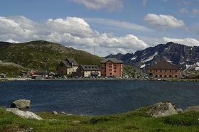
The hospice (إيطالية: Ospizio) is located south of the pass at 2,091 metres (6,860 ft), near the Lago della Piazza and other small lakes. Lago di Lucendro and Lago Sella are larger reservoir lakes accessible from the pass.
جسر الشيطان
الأنفاق
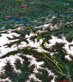
Several tunnels provide access through the pass. The 15 kilometres (9.3 mi) Gotthard Rail Tunnel was the first and opened in 1882 for railway traffic at a cost of around 200 workers' lives (there is uncertainty as to the exact toll). It bypassed the pass road, connecting Göschenen with Airolo.[1]
A 17 kilometres (11 mi) motorway tunnel, the Gotthard Road Tunnel opened in 1980. It was closed for two months in 2001 following a fatal fire.
The Gotthard Base Tunnel was opened on 1 June 2016. It is the longest rail tunnel in the world at 57.091 kilometres (35.475 mi). This tunnel, combined with two shorter tunnels planned near Zürich and Lugano as part of the NRLA project, will reduce the 3 hour 40 min rail journey from Zürich to Milan by one hour, while increasing the size and number of trains that can operate along the route because the line is nearly level, compared with the spirals of the older tunnel.
في الثقافة الشعبية
انظر أيضاً
- List of highest paved roads in Europe
- List of mountain passes
- List of the highest Swiss passes
- Gotthard Tunnel
Bibliography
- Nicola Pfund, Sui passi in bicicletta - Swiss Alpine passes by bicycle, Fontana Edizioni, 2012, p. 78-87. ISBN 978-88-8191-281-0
References
- ^ Hans-Peter Bärtschi: Gotthardbahn in German, French and Italian in the online Historical Dictionary of Switzerland. Version of 2004-07-29.
- ^ Rebecca Silverman (September 7, 2013). "Wolfsmund GN 1". Anime News Network. Retrieved June 7, 2015.
وصلات خارجية
- Pages using gadget WikiMiniAtlas
- Articles containing إيطالية-language text
- Pages using Lang-xx templates
- Articles containing ألمانية-language text
- Articles containing إنگليزية-language text
- Coordinates on Wikidata
- Mountain passes of Ticino
- Mountain passes of the Alps
- Mountain passes of the canton of Uri
- Tourist attractions in Switzerland
- Tourist attractions in Ticino
- Tourist attractions in the canton of Uri
- Lepontine Alps
