مقاطعة ملهير، أوريگون
Malheur County | |
|---|---|
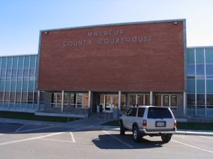
 Malheur County Courthouse in Vale | |
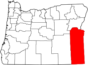
 الموقع ضمن ولاية Oregon | |
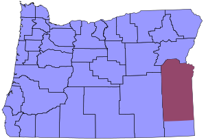
 موقع Oregon ضمن الولايات المتحدة | |
| الإحداثيات: 43°13′N 117°38′W / 43.217°N 117.633°W | |
| البلد | |
| State | |
| تأسست | 17 فبراير, 1887 |
| السمِيْ | نهر ملهير |
| Seat | Vale |
| Largest city | أونتاريو |
| المساحة | |
| • الإجمالي | 9٬930 ميل² (25٬700 كم²) |
| • البر | 9٬888 ميل² (25٬610 كم²) |
| • الماء | 42 ميل² (110 كم²) 0.4%% |
| التعداد | |
| • Estimate (2018) | 30٬725 |
| • الكثافة | 3٫2/sq mi (1٫2/km2) |
| منطقة التوقيت | |
| primary | UTC−7 (Mountain) |
| • الصيف (التوقيت الصيفي) | UTC−6 (MDT) |
| southern fifth | UTC−8 (Pacific) |
| • Summer (DST) | UTC−7 (PDT) |
| Congressional district | 2nd |
| الموقع الإلكتروني | www |
مقاطعة ملهير (إنگليزية: Malheur County؛ /mælˈhɪər/) هي إحدى مقاطعات ولاية أوريگون في الولايات المتحدة. As of the 2010 census, the population was 31,313.[1] Its county seat is Vale,[2] and its largest city is Ontario. The county was named after the Malheur River, which runs through the county. The word "malheur" is French for misfortune or tragedy.[3]
Malheur County is included in the Ontario, Oregon Micropolitan Statistical Area, which is also included in the Boise Combined Statistical Area. It is included in the eight-county definition of Eastern Oregon.
. . . . . . . . . . . . . . . . . . . . . . . . . . . . . . . . . . . . . . . . . . . . . . . . . . . . . . . . . . . . . . . . . . . . . . . . . . . . . . . . . . . . . . . . . . . . . . . . . . . . . . . . . . . . . . . . . . . . . . . . . . . . . . . . . . . . . . . . . . . . . . . . . . . . . . . . . . . . . . . . . . . . . . . .
التاريخ
Malheur County was created February 17, 1887, from the southern portion of Baker County. It was first settled by miners and stockmen in the early 1860s. The discovery of gold in 1863 attracted further development, including settlements and ranches. الباسك settled in the region in the 1890s and were mainly engaged in sheep raising.
الجغرافيا
المقاطعات المجاورة
- Baker County - north/Pacific Time Border
- Washington County, Idaho - northeast
- Payette County, Idaho - east
- Canyon County, Idaho - east
- Owyhee County, Idaho - east
- Humboldt County, Nevada - south
- Harney County - west/Pacific Time Border
- Grant County - northwest/Pacific Time Border
National protected areas
- Deer Flat National Wildlife Refuge (part)
- Malheur National Forest (part)
- Whitman National Forest (part)
الطرق السريعة
- Invalid type: I
- Invalid type: US
- Invalid type: US
- Invalid type: US
- Invalid type: US-Bus
- Invalid type: US
- Invalid type: OR
- Invalid type: OR
- Invalid type: OR
السكك الحديدية

مناطق التوقيت

مقاطعة ملهير هي واحدة من المقاطعات القليلة في الولايات المتحدة التي يوجد فيها منطقتا توقيت. فمعظم المقاطعة يتبع منطقة توقيت الجبل، إلا أن جزءاً صغيراً في الجنوب يتبع منطقة توقيت الهادي.
الديمغرافيا
| التعداد التاريخي | |||
|---|---|---|---|
| التعداد | Pop. | %± | |
| 1890 | 2٬601 | — | |
| 1900 | 4٬203 | 61٫6% | |
| 1910 | 8٬601 | 104٫6% | |
| 1920 | 10٬907 | 26٫8% | |
| 1930 | 11٬269 | 3٫3% | |
| 1940 | 19٬767 | 75٫4% | |
| 1950 | 23٬223 | 17٫5% | |
| 1960 | 22٬764 | −2�0% | |
| 1970 | 23٬169 | 1٫8% | |
| 1980 | 26٬896 | 16٫1% | |
| 1990 | 26٬038 | −3٫2% | |
| 2000 | 31٬615 | 21٫4% | |
| 2010 | 31٬313 | −1�0% | |
| 2018 (تق.) | 30٬725 | [4] | −1٫9% |
| U.S. Decennial Census[5] 1790-1960[6] 1900-1990[7] 1990-2000[8] 2010-2018[1] | |||
| Year | Republican | Democratic | Third parties |
|---|---|---|---|
| 2016 | 68.9% 7,194 | 21.5% 2,246 | 9.5% 995 |
| 2012 | 68.8% 6,851 | 27.7% 2,759 | 3.5% 346 |
| 2008 | 68.6% 7,157 | 28.3% 2,949 | 3.1% 327 |
| 2004 | 74.9% 8,123 | 23.8% 2,577 | 1.4% 146 |
| 2000 | 73.3% 7,624 | 22.5% 2,336 | 4.3% 444 |
| 1996 | 61.1% 6,045 | 28.6% 2,827 | 10.3% 1,020 |
| 1992 | 50.4% 5,374 | 23.8% 2,539 | 25.8% 2,750 |
| 1988 | 66.6% 6,285 | 31.4% 2,965 | 2.0% 193 |
| 1984 | 76.2% 8,441 | 23.6% 2,611 | 0.2% 19 |
| 1980 | 67.8% 7,705 | 25.8% 2,937 | 6.4% 722 |
| 1976 | 59.1% 5,682 | 36.5% 3,507 | 4.4% 421 |
| 1972 | 67.4% 5,908 | 21.3% 1,870 | 11.3% 993 |
| 1968 | 65.2% 5,447 | 24.2% 2,021 | 10.7% 892 |
| 1964 | 52.3% 4,177 | 47.6% 3,798 | 0.1% 8 |
| 1960 | 59.9% 5,043 | 40.1% 3,381 | 0.0% 0 |
| 1956 | 61.3% 4,981 | 38.8% 3,151 | 0.0% 0 |
| 1952 | 70.5% 5,414 | 29.2% 2,245 | 0.3% 26 |
| 1948 | 55.4% 3,265 | 42.4% 2,499 | 2.3% 134 |
| 1944 | 55.1% 2,797 | 44.0% 2,234 | 0.9% 47 |
| 1940 | 49.4% 2,929 | 49.9% 2,958 | 0.7% 42 |
| 1936 | 31.4% 1,385 | 59.6% 2,630 | 9.0% 395 |
| 1932 | 42.3% 1,589 | 53.9% 2,025 | 3.7% 140 |
| 1928 | 67.4% 2,164 | 31.6% 1,016 | 1.0% 33 |
| 1924 | 51.9% 1,671 | 25.7% 828 | 22.3% 718 |
| 1920 | 65.0% 2,352 | 29.7% 1,075 | 5.3% 193 |
| 1916 | 42.4% 1,682 | 48.8% 1,937 | 8.8% 350 |
| 1912 | 33.8% 648 | 34.2% 656 | 32.1% 615 |
| 1908 | 54.4% 800 | 36.9% 543 | 8.6% 127 |
| 1904 | 63.8% 799 | 22.4% 280 | 13.8% 173 |
. . . . . . . . . . . . . . . . . . . . . . . . . . . . . . . . . . . . . . . . . . . . . . . . . . . . . . . . . . . . . . . . . . . . . . . . . . . . . . . . . . . . . . . . . . . . . . . . . . . . . . . . . . . . . . . . . . . . . . . . . . . . . . . . . . . . . . . . . . . . . . . . . . . . . . . . . . . . . . . . . . . . . . . .
الاقتصاد
المقاطعة هي عبارة عن 94% مراعي، يسيطر مكتب ادارة الأراضي (BLM) على 72% من الأرض. الحقول المروية في الركن الشمالي الشرقي من المقاطعة، الذي يُعرف بإسم وادي الكنز Treasure Valley الغربي، هي مركز زراعة مكثفة ومتنوعة. كما يعتمد اقتصاد ملهير على السياحة.

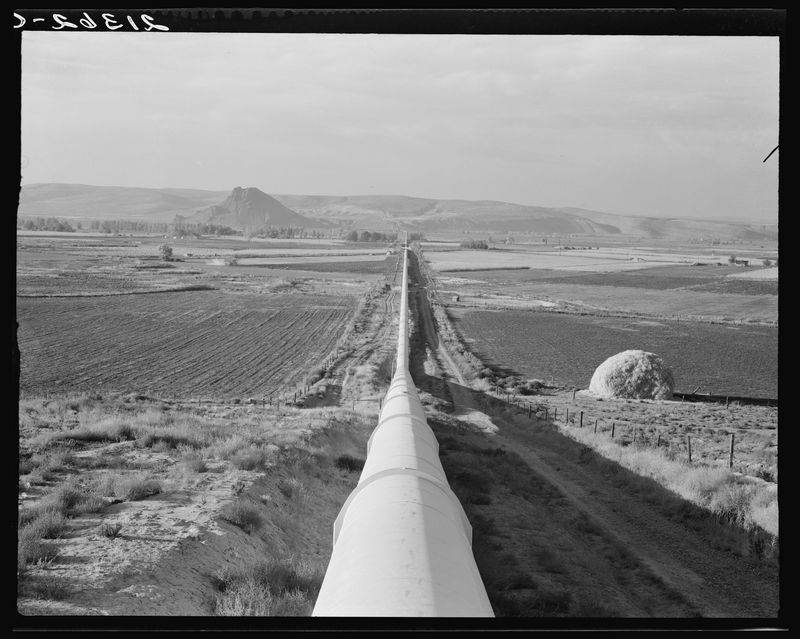
وتضم المقاطعة أطول سحارة في العالم، بطول خمسة أميال (8 كيلومتر) وبقطر 240 سم، لنقل الماء إلى دد أوكس فلات Dead Ox Flat.
The county's two largest employers are the Heinz Frozen Food Company of Ontario, a potato processor branded as Ore-Ida, and the Snake River Correctional Institution, five miles northwest of Ontario.[10]
التجمعات السكنية
المدن
- Adrian
- Jordan Valley
- Nyssa
- Ontario
- Vale (county seat)
Census-designated places
Other unincorporated communities
بلدات الأشباح
- Inskip Station
- Leslie Gulch
- ملهير
- Westfall
انظر أيضاً
- National Register of Historic Places listings in Malheur County, Oregon
- Malheur Enterprise, local newspaper of public record
المراجع
- ^ أ ب "State & County QuickFacts". United States Census Bureau. Archived from the original on June 20, 2011. Retrieved November 15, 2013.
- ^ "Find a County". National Association of Counties. Retrieved June 7, 2011.
- ^ "malheur - traduction - Dictionnaire Français-Anglais WordReference.com". www.wordreference.com (in الفرنسية). Retrieved April 11, 2018.
- ^ "Population and Housing Unit Estimates". Retrieved May 9, 2019.
- ^ "U.S. Decennial Census". United States Census Bureau. Retrieved February 26, 2015.
- ^ "Historical Census Browser". University of Virginia Library. Retrieved February 26, 2015.
- ^ Forstall, Richard L., ed. (March 27, 1995). "Population of Counties by Decennial Census: 1900 to 1990". United States Census Bureau. Retrieved February 26, 2015.
- ^ "Census 2000 PHC-T-4. Ranking Tables for Counties: 1990 and 2000" (PDF). United States Census Bureau. April 2, 2001. Retrieved February 26, 2015.
- ^ Leip, David. "Dave Leip's Atlas of U.S. Presidential Elections". uselectionatlas.org. Retrieved 2018-04-11.
- ^ Jacklet, Ben (April 2008). "Prisontown myth". Oregon Business magazine. Archived from the original on 2008-12-02. Retrieved 2008-03-25.
وصلات خارجية
- Malheur County (official website)
- Information about Malheur County from Oregon State University Malheur Experiment Station
- CS1 الفرنسية-language sources (fr)
- Pages using gadget WikiMiniAtlas
- Short description is different from Wikidata
- مقاطعات Oregon
- Articles containing إنگليزية-language text
- Pages using Lang-xx templates
- Articles with hatnote templates targeting a nonexistent page
- Jct template errors
- Pages using US Census population needing update
- Portal-inline template with redlinked portals
- Pages with empty portal template
- Coordinates on Wikidata
- Malheur County, Oregon
- Ontario, Oregon micropolitan area
- Counties in multiple time zones
- Basque-American culture in Oregon
- 1887 establishments in Oregon
- Populated places established in 1887
- مقاطعات ولاية أوريغون الأمريكية
