مقاطعة لوگن، كانزس
Logan County | |
|---|---|
 | |
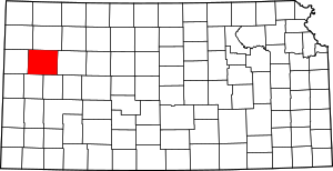
 الموقع ضمن ولاية Kansas | |
 موقع Kansas ضمن الولايات المتحدة | |
| الإحداثيات: 38°54′N 101°08′W / 38.900°N 101.133°W | |
| البلد | |
| State | |
| تأسست | February 24, 1887 |
| السمِيْ | John A. Logan |
| Seat | Oakley |
| Largest city | Oakley |
| المساحة | |
| • الإجمالي | 1٬073 ميل² (2٬780 كم²) |
| • البر | 1٬073 ميل² (2٬780 كم²) |
| • الماء | 0٫1 ميل² (0٫3 كم²) 0.01%% |
| التعداد | |
| • الإجمالي | 2٬762 |
| • الكثافة | 2٫6/sq mi (1�0/km2) |
| منطقة التوقيت | UTC−6 (Central) |
| • الصيف (التوقيت الصيفي) | UTC−5 (CDT) |
| Congressional district | 1st |
| الموقع الإلكتروني | discoveroakley.com |
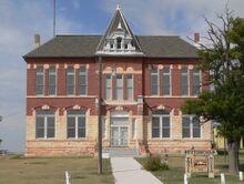
مقاطعة لوگن إنگليزية: Logan County هي إحدى المقاطعات في ولاية كانزس، الولايات المتحدة.
. . . . . . . . . . . . . . . . . . . . . . . . . . . . . . . . . . . . . . . . . . . . . . . . . . . . . . . . . . . . . . . . . . . . . . . . . . . . . . . . . . . . . . . . . . . . . . . . . . . . . . . . . . . . . . . . . . . . . . . . . . . . . . . . . . . . . . . . . . . . . . . . . . . . . . . . . . . . . . . . . . . . . . . .
الجغرافيا
الطرق الرئيسية
المقاطعات المجاورة
- Thomas County (north)
- Gove County (east)
- Scott County (southeast)
- Wichita County (south)
- Wallace County (west/Mountain Time border)
- Sherman County (northwest/Mountain Time border)
السكان
| التعداد التاريخي | |||
|---|---|---|---|
| التعداد | Pop. | %± | |
| 1890 | 3٬384 | — | |
| 1900 | 1٬962 | −42�0% | |
| 1910 | 4٬240 | 116٫1% | |
| 1920 | 3٬223 | −24�0% | |
| 1930 | 4٬145 | 28٫6% | |
| 1940 | 3٬688 | −11�0% | |
| 1950 | 4٬206 | 14�0% | |
| 1960 | 4٬036 | −4�0% | |
| 1970 | 3٬814 | −5٫5% | |
| 1980 | 3٬478 | −8٫8% | |
| 1990 | 3٬081 | −11٫4% | |
| 2000 | 3٬046 | −1٫1% | |
| 2010 | 2٬756 | −9٫5% | |
| 2020 | 2٬762 | 0٫2% | |
| U.S. Decennial Census[2] 1790-1960[3] 1900-1990[4] 1990-2000[5] 2010-2020[1] | |||
الحكومة
الانتخابات الرئاسية
| السنة | الجمهوري | الديمقراطي | حزب ثالث | |||
|---|---|---|---|---|---|---|
| رقم. | % | رقم. | % | رقم. | % | |
| 2020 | 1,249 | 85٫67% | 186 | 12٫76% | 23 | 1٫58% |
| 2016 | 1,132 | 83٫42% | 149 | 10٫98% | 76 | 5٫60% |
| 2012 | 1,126 | 83٫41% | 197 | 14٫59% | 27 | 2�00% |
| 2008 | 1,187 | 82٫43% | 225 | 15٫63% | 28 | 1٫94% |
| 2004 | 1,255 | 82٫40% | 248 | 16٫28% | 20 | 1٫31% |
| 2000 | 1,088 | 77٫88% | 231 | 16٫54% | 78 | 5٫58% |
| 1996 | 1,155 | 73٫47% | 296 | 18٫83% | 121 | 7٫70% |
| 1992 | 905 | 52٫95% | 355 | 20٫77% | 449 | 26٫27% |
| 1988 | 988 | 64٫36% | 503 | 32٫77% | 44 | 2٫87% |
| 1984 | 1,235 | 77٫04% | 331 | 20٫65% | 37 | 2٫31% |
| 1980 | 1,261 | 72٫89% | 358 | 20٫69% | 111 | 6٫42% |
| 1976 | 957 | 56٫39% | 694 | 40٫90% | 46 | 2٫71% |
| 1972 | 1,164 | 69٫99% | 428 | 25٫74% | 71 | 4٫27% |
| 1968 | 1,120 | 63٫78% | 411 | 23٫41% | 225 | 12٫81% |
| 1964 | 967 | 49٫82% | 957 | 49٫30% | 17 | 0٫88% |
| 1960 | 1,243 | 65٫22% | 651 | 34٫16% | 12 | 0٫63% |
| 1956 | 1,328 | 72٫61% | 493 | 26٫95% | 8 | 0٫44% |
| 1952 | 1,544 | 79٫96% | 369 | 19٫11% | 18 | 0٫93% |
| 1948 | 1,105 | 63٫73% | 579 | 33٫39% | 50 | 2٫88% |
| 1944 | 1,107 | 72٫92% | 406 | 26٫75% | 5 | 0٫33% |
| 1940 | 1,201 | 66٫83% | 584 | 32٫50% | 12 | 0٫67% |
| 1936 | 955 | 51٫15% | 908 | 48٫63% | 4 | 0٫21% |
| 1932 | 867 | 44٫26% | 1,025 | 52٫32% | 67 | 3٫42% |
| 1928 | 1,066 | 71٫64% | 405 | 27٫22% | 17 | 1٫14% |
| 1924 | 942 | 63٫86% | 286 | 19٫39% | 247 | 16٫75% |
| 1920 | 781 | 68٫51% | 312 | 27٫37% | 47 | 4٫12% |
| 1916 | 592 | 42٫05% | 709 | 50٫36% | 107 | 7٫60% |
| 1912 | 166 | 20٫22% | 259 | 31٫55% | 396 | 48٫23% |
| 1908 | 524 | 59٫34% | 308 | 34٫88% | 51 | 5٫78% |
| 1904 | 408 | 71٫83% | 117 | 20٫60% | 43 | 7٫57% |
| 1900 | 319 | 60٫53% | 176 | 33٫40% | 32 | 6٫07% |
| 1896 | 274 | 60٫35% | 175 | 38٫55% | 5 | 1٫10% |
| 1892 | 457 | 58٫14% | 0 | 0�00% | 329 | 41٫86% |
| 1888 | 609 | 65٫84% | 283 | 30٫59% | 33 | 3٫57% |
. . . . . . . . . . . . . . . . . . . . . . . . . . . . . . . . . . . . . . . . . . . . . . . . . . . . . . . . . . . . . . . . . . . . . . . . . . . . . . . . . . . . . . . . . . . . . . . . . . . . . . . . . . . . . . . . . . . . . . . . . . . . . . . . . . . . . . . . . . . . . . . . . . . . . . . . . . . . . . . . . . . . . . . .
التجمعات
المدن
تجمعات غير مشهرة
بلدات مهجورة
بلدات كبيرة
Logan County is divided into eleven townships. None of the cities within the county is considered governmentally independent, and all figures for the townships include those of the cities.
In the following table, the population center is the largest city (or cities) included in that township's population total, if it is of a significant size.
| Township | FIPS | Population center |
Population | Population density /km2 (/sq mi) |
Land area km2 (sq mi) |
Water area km2 (sq mi) |
Water % | Geographic coordinates |
|---|---|---|---|---|---|---|---|---|
| Augustine | 03350 | 26 | 0 (0) | 187 (72) | 0 (0) | 0% | 38°44′14″N 101°21′15″W / 38.73722°N 101.35417°W | |
| Elkader | 20225 | 15 | 0 (0) | 278 (107) | 0 (0) | 0.01% | 38°53′33″N 100°52′1″W / 38.89250°N 100.86694°W | |
| Lees | 39200 | 17 | 0 (0) | 185 (72) | 0 (0) | 0% | 38°44′26″N 100°59′5″W / 38.74056°N 100.98472°W | |
| Logansport | 42325 | 14 | 0 (0) | 278 (107) | 0 (0) | 0.01% | 38°51′29″N 101°4′9″W / 38.85806°N 101.06917°W | |
| McAllaster | 43600 | 29 | 0 (0) | 276 (106) | 0 (0) | 0.01% | 39°2′58″N 101°22′4″W / 39.04944°N 101.36778°W | |
| Monument | 48050 | 144 | 1 (1) | 276 (107) | 0 (0) | 0% | 39°4′17″N 101°2′42″W / 39.07139°N 101.04500°W | |
| Oakley | 51850 | Oakley | 2,343 | 8 (22) | 278 (107) | 0 (0) | 0.01% | 39°6′43″N 100°51′32″W / 39.11194°N 100.85889°W |
| Paxton | 55025 | 24 | 0 (0) | 186 (72) | 0 (0) | 0% | 38°44′38″N 101°7′57″W / 38.74389°N 101.13250°W | |
| Russell Springs | 61900 | 71 | 0 (1) | 279 (108) | 0 (0) | 0.03% | 38°53′16″N 101°12′15″W / 38.88778°N 101.20417°W | |
| Western | 76900 | 44 | 0 (0) | 279 (108) | 0 (0) | 0.04% | 38°54′3″N 101°24′37″W / 38.90083°N 101.41028°W | |
| Winona | 80100 | Winona | 319 | 1 (3) | 277 (107) | 0 (0) | 0% | 39°3′53″N 101°12′54″W / 39.06472°N 101.21500°W |
انظر أيضاً
. . . . . . . . . . . . . . . . . . . . . . . . . . . . . . . . . . . . . . . . . . . . . . . . . . . . . . . . . . . . . . . . . . . . . . . . . . . . . . . . . . . . . . . . . . . . . . . . . . . . . . . . . . . . . . . . . . . . . . . . . . . . . . . . . . . . . . . . . . . . . . . . . . . . . . . . . . . . . . . . . . . . . . . .
المراجع
- ^ أ ب خطأ استشهاد: وسم
<ref>غير صحيح؛ لا نص تم توفيره للمراجع المسماةQF - ^ "U.S. Decennial Census". United States Census Bureau. Retrieved July 26, 2014.
- ^ "Historical Census Browser". University of Virginia Library. Retrieved July 26, 2014.
- ^ "Population of Counties by Decennial Census: 1900 to 1990". United States Census Bureau. Retrieved July 26, 2014.
- ^ "Census 2000 PHC-T-4. Ranking Tables for Counties: 1990 and 2000" (PDF). United States Census Bureau. Archived (PDF) from the original on 2010-03-27. Retrieved July 26, 2014.
- ^ "Dave Leip's Atlas of U.S. Presidential Elections".
- ملاحظات
للاستزادة
وصلات خارجية
- المقاطعة
- الخرائط
- Pages using gadget WikiMiniAtlas
- Short description is different from Wikidata
- Articles with hatnote templates targeting a nonexistent page
- Coordinates on Wikidata
- مقاطعات Kansas
- Pages using infobox U.S. county with unknown parameters
- Articles containing إنگليزية-language text
- Pages using Lang-xx templates
- Pages with empty portal template
- Official website different in Wikidata and Wikipedia
- مقاطعة لوگن، كانزس
- Kansas counties
- 1887 establishments in Kansas
- Populated places established in 1887
- مقاطعات كانزاس


