مقاطعة كالهون، إلينوي
Calhoun County | |
|---|---|
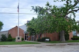
 Calhoun County Courthouse in Hardin | |
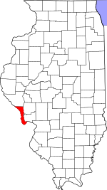
 الموقع ضمن ولاية Illinois | |
 موقع Illinois ضمن الولايات المتحدة | |
| الإحداثيات: 39°10′N 90°40′W / 39.16°N 90.67°W | |
| البلد | |
| State | |
| تأسست | 1825 |
| السمِيْ | John C. Calhoun |
| Seat | Hardin |
| Largest village | Hardin |
| المساحة | |
| • الإجمالي | 284 ميل² (740 كم²) |
| • البر | 254 ميل² (660 كم²) |
| • الماء | 30 ميل² (80 كم²) 10.5% |
| التعداد (2010) | |
| • الإجمالي | 5٬089 |
| • Estimate (2019) | 4٬739 |
| • الكثافة | 18/sq mi (6٫9/km2) |
| منطقة التوقيت | UTC−6 (Central) |
| • الصيف (التوقيت الصيفي) | UTC−5 (CDT) |
| Congressional district | 13th |
مقاطعة كالهون إنگليزية: Calhoun County هي إحدى المقاطعات في ولاية إلينوي في الولايات المتحدة. As of the 2010 census, the population was 5,089,[1] making it Illinois’ third-least populous county. Its county seat and biggest community is Hardin, with a population of 801.[2] Its smallest incorporated community is Hamburg, with a population of 99. Calhoun County is at the tip of the peninsula formed by the courses of the Mississippi and Illinois rivers above their confluence and is almost completely surrounded by water. Calhoun County is sparsely populated; it has just five municipalities, all of them villages.[3]
Calhoun County is part of the Metro-East portion of the St. Louis, MO-IL Metropolitan Statistical Area.
. . . . . . . . . . . . . . . . . . . . . . . . . . . . . . . . . . . . . . . . . . . . . . . . . . . . . . . . . . . . . . . . . . . . . . . . . . . . . . . . . . . . . . . . . . . . . . . . . . . . . . . . . . . . . . . . . . . . . . . . . . . . . . . . . . . . . . . . . . . . . . . . . . . . . . . . . . . . . . . . . . . . . . . .
المقاطعات المجاورة
- Greene County – northeast
- Jersey County – east
- St. Charles County, Missouri – south
- Lincoln County, Missouri – west
- Pike County, Illinois – north
- Pike County, Missouri – northwest
Climate and weather
| Hardin, Illinois | ||||||||||||||||||||||||||||||||||||||||||||||||||||||||||||
|---|---|---|---|---|---|---|---|---|---|---|---|---|---|---|---|---|---|---|---|---|---|---|---|---|---|---|---|---|---|---|---|---|---|---|---|---|---|---|---|---|---|---|---|---|---|---|---|---|---|---|---|---|---|---|---|---|---|---|---|---|
| جدول الطقس (التفسير) | ||||||||||||||||||||||||||||||||||||||||||||||||||||||||||||
| ||||||||||||||||||||||||||||||||||||||||||||||||||||||||||||
| ||||||||||||||||||||||||||||||||||||||||||||||||||||||||||||
In recent years, average temperatures in the county seat of Hardin have ranged from a low of 19 °F (−7 °C) in January to a high of 90 °F (32 °C) in July, although a record low of −24 °F (−31 °C) was recorded in January 1979 and a record high of 116 °F (47 °C) was recorded in July 1954. Average monthly precipitation ranged from 2.01 inches (51 mm) in January to 4.10 inches (104 mm) in May.[4]
. . . . . . . . . . . . . . . . . . . . . . . . . . . . . . . . . . . . . . . . . . . . . . . . . . . . . . . . . . . . . . . . . . . . . . . . . . . . . . . . . . . . . . . . . . . . . . . . . . . . . . . . . . . . . . . . . . . . . . . . . . . . . . . . . . . . . . . . . . . . . . . . . . . . . . . . . . . . . . . . . . . . . . . .
السكان
| التعداد التاريخي | |||
|---|---|---|---|
| التعداد | Pop. | %± | |
| 1830 | 1٬090 | — | |
| 1840 | 1٬740 | 59٫6% | |
| 1850 | 3٬231 | 85٫7% | |
| 1860 | 5٬144 | 59٫2% | |
| 1870 | 6٬562 | 27٫6% | |
| 1880 | 7٬467 | 13٫8% | |
| 1890 | 7٬652 | 2٫5% | |
| 1900 | 8٬917 | 16٫5% | |
| 1910 | 8٬610 | −3٫4% | |
| 1920 | 8٬245 | −4٫2% | |
| 1930 | 8٬034 | −2٫6% | |
| 1940 | 8٬207 | 2٫2% | |
| 1950 | 6٬898 | −15٫9% | |
| 1960 | 5٬933 | −14�0% | |
| 1970 | 5٬675 | −4٫3% | |
| 1980 | 5٬867 | 3٫4% | |
| 1990 | 5٬322 | −9٫3% | |
| 2000 | 5٬084 | −4٫5% | |
| 2010 | 5٬089 | 0٫1% | |
| 2020 | 4٬437 | −12٫8% | |
| U.S. Decennial Census[5] 1790-1960[6] 1900-1990[7] 1990-2000[8] 2010-2017[1] | |||
السياسة
| السنة | الجمهوري | الديمقراطي | حزب ثالث | |||
|---|---|---|---|---|---|---|
| رقم. | % | رقم. | % | رقم. | % | |
| 2020 | 2,046 | 73٫81% | 677 | 24٫42% | 49 | 1٫77% |
| 2016 | 1,721 | 66٫94% | 739 | 28٫74% | 111 | 4٫32% |
| 2012 | 1,440 | 55٫90% | 1,080 | 41٫93% | 56 | 2٫17% |
| 2008 | 1,221 | 45٫12% | 1,423 | 52٫59% | 62 | 2٫29% |
| 2004 | 1,317 | 48٫67% | 1,367 | 50٫52% | 22 | 0٫81% |
| 2000 | 1,229 | 47٫23% | 1,310 | 50٫35% | 63 | 2٫42% |
| 1996 | 941 | 31٫23% | 1,676 | 55٫63% | 396 | 13٫14% |
| 1992 | 745 | 26٫58% | 1,519 | 54٫19% | 539 | 19٫23% |
| 1988 | 1,238 | 44٫37% | 1,544 | 55٫34% | 8 | 0٫29% |
| 1984 | 1,648 | 53٫04% | 1,443 | 46٫44% | 16 | 0٫51% |
| 1980 | 1,591 | 54٫96% | 1,208 | 41٫73% | 96 | 3٫32% |
| 1976 | 1,364 | 46٫35% | 1,549 | 52٫63% | 30 | 1٫02% |
| 1972 | 1,705 | 56٫51% | 1,299 | 43٫06% | 13 | 0٫43% |
| 1968 | 1,542 | 49٫12% | 1,329 | 42٫34% | 268 | 8٫54% |
| 1964 | 1,288 | 41٫64% | 1,805 | 58٫36% | 0 | 0�00% |
| 1960 | 1,654 | 50٫63% | 1,608 | 49٫22% | 5 | 0٫15% |
| 1956 | 1,892 | 55٫79% | 1,498 | 44٫18% | 1 | 0٫03% |
| 1952 | 1,915 | 56٫81% | 1,454 | 43٫13% | 2 | 0٫06% |
| 1948 | 1,526 | 52٫21% | 1,377 | 47٫11% | 20 | 0٫68% |
| 1944 | 1,956 | 60٫35% | 1,271 | 39٫22% | 14 | 0٫43% |
| 1940 | 2,516 | 60٫51% | 1,625 | 39٫08% | 17 | 0٫41% |
| 1936 | 1,883 | 45٫90% | 2,058 | 50٫17% | 161 | 3٫92% |
| 1932 | 1,239 | 35٫36% | 2,229 | 63٫61% | 36 | 1٫03% |
| 1928 | 1,594 | 50٫16% | 1,551 | 48٫80% | 33 | 1٫04% |
| 1924 | 1,136 | 48٫12% | 1,115 | 47٫23% | 110 | 4٫66% |
| 1920 | 1,367 | 64٫82% | 703 | 33٫33% | 39 | 1٫85% |
| 1916 | 1,168 | 48٫40% | 1,181 | 48٫94% | 64 | 2٫65% |
| 1912 | 373 | 30٫62% | 602 | 49٫43% | 243 | 19٫95% |
| 1908 | 735 | 42٫58% | 905 | 52٫43% | 86 | 4٫98% |
| 1904 | 730 | 42٫77% | 815 | 47٫74% | 162 | 9٫49% |
| 1900 | 873 | 41٫99% | 1,175 | 56٫52% | 31 | 1٫49% |
| 1896 | 795 | 40٫03% | 1,176 | 59٫21% | 15 | 0٫76% |
| 1892 | 563 | 35٫68% | 840 | 53٫23% | 175 | 11٫09% |
. . . . . . . . . . . . . . . . . . . . . . . . . . . . . . . . . . . . . . . . . . . . . . . . . . . . . . . . . . . . . . . . . . . . . . . . . . . . . . . . . . . . . . . . . . . . . . . . . . . . . . . . . . . . . . . . . . . . . . . . . . . . . . . . . . . . . . . . . . . . . . . . . . . . . . . . . . . . . . . . . . . . . . . .
انظر أيضاً
المراجع
- المحددة
- ^ أ ب "State & County QuickFacts". United States Census Bureau. Archived from the original on يونيو 6, 2011. Retrieved يوليو 4, 2014.
- ^ "Find a County". National Association of Counties. Archived from the original on مايو 31, 2011. Retrieved يونيو 7, 2011.
- ^ "Visitors Guide to Calhoun County". greatriverroad.com. Archived from the original on يوليو 7, 2012. Retrieved أغسطس 11, 2012.
- ^ أ ب "Monthly Averages for Hardin, Illinois". The Weather Channel. Retrieved يناير 27, 2011.
- ^ "U.S. Decennial Census". United States Census Bureau. Retrieved يوليو 4, 2014.
- ^ "Historical Census Browser". University of Virginia Library. Retrieved يوليو 4, 2014.
- ^ "Population of Counties by Decennial Census: 1900 to 1990". United States Census Bureau. Retrieved يوليو 4, 2014.
- ^ "Census 2000 PHC-T-4. Ranking Tables for Counties: 1990 and 2000" (PDF). United States Census Bureau. Retrieved يوليو 4, 2014.
- ^ Leip, David. "Dave Leip's Atlas of U.S. Presidential Elections". uselectionatlas.org. Retrieved أكتوبر 29, 2018.
- العامة
- United States Census Bureau 2007 TIGER/Line Shapefiles
- United States Board on Geographic Names (GNIS)
- United States National Atlas
وصلات خارجية
- Illinois Genealogy Trails: Calhoun County, Illinois
- History of Calhoun County, Illinois
- Calhoun County Unit 40

|
Greene County | Pike County | Pike County, Missouri | 
|
| Jersey County | Lincoln County, Missouri | |||
| St. Charles County, Missouri |
- Pages using gadget WikiMiniAtlas
- Short description is different from Wikidata
- Use mdy dates from November 2019
- Coordinates on Wikidata
- مقاطعات Illinois
- Pages using infobox U.S. county with unknown parameters
- Articles containing إنگليزية-language text
- Pages using Lang-xx templates
- Portal-inline template with redlinked portals
- Pages with empty portal template
- مقاطعة كالهون، إلينوي
- Illinois counties
- 1825 establishments in Illinois
- Populated places established in 1825
- Illinois counties on the Mississippi River
- Sundown towns in Illinois
- مقاطعات ولاية إلينوي الأمريكية

