مقاطعة سيمينول، جورجيا
Seminole County | |
|---|---|
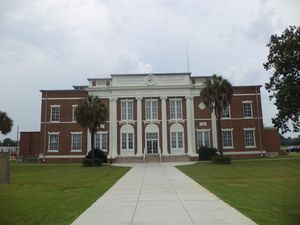
 Seminole County Courthouse in Donalsonville | |
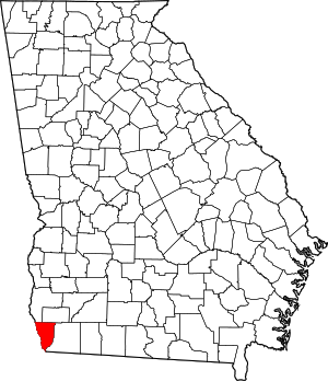
 الموقع ضمن ولاية Georgia | |
 موقع Georgia ضمن الولايات المتحدة | |
| الإحداثيات: 30°56′N 84°52′W / 30.93°N 84.87°W | |
| البلد | |
| State | |
| تأسست | November 2, 1920 |
| السمِيْ | Seminole tribe |
| Seat | Donalsonville |
| Largest city | Donalsonville |
| المساحة | |
| • الإجمالي | 257 ميل² (670 كم²) |
| • البر | 235 ميل² (610 كم²) |
| • الماء | 21 ميل² (50 كم²) 8.3%% |
| التعداد | |
| • Estimate (2018) | 8٬315 |
| • الكثافة | 37/sq mi (14/km2) |
| منطقة التوقيت | UTC−5 (Eastern) |
| • الصيف (التوقيت الصيفي) | UTC−4 (EDT) |
| Congressional district | 2nd |
| الموقع الإلكتروني | www |
مقاطعة سمينول إنگليزية: Seminole County هي إحدى المقاطعات في ولاية جورجيا في الولايات المتحدة.
. . . . . . . . . . . . . . . . . . . . . . . . . . . . . . . . . . . . . . . . . . . . . . . . . . . . . . . . . . . . . . . . . . . . . . . . . . . . . . . . . . . . . . . . . . . . . . . . . . . . . . . . . . . . . . . . . . . . . . . . . . . . . . . . . . . . . . . . . . . . . . . . . . . . . . . . . . . . . . . . . . . . . . . .
التاريخ
The state constitutional amendment to create the County was proposed July 8, 1920, and ratified November 2, 1920. The area for the new county was taken from land which was originally part of Decatur and Early counties. It is named for the Seminole tribe of Native Americans, who once lived in the Chattahoochee River basin within the county, before European settlement forced their move to the Florida everglades. According to legend, the celebrated Seminole chief Osceola was born in what is today Seminole County.[1]
السياسة
| Year | Republican | Democratic | Third parties |
|---|---|---|---|
| 2016 | 65.4% 2,345 | 33.1% 1,189 | 1.5% 54 |
| 2012 | 59.4% 2,245 | 39.1% 1,478 | 1.4% 54 |
| 2008 | 57.8% 2,315 | 41.4% 1,660 | 0.8% 32 |
| 2004 | 60.3% 1,977 | 39.0% 1,278 | 0.8% 26 |
| 2000 | 53.4% 1,537 | 45.6% 1,313 | 0.9% 27 |
| 1996 | 39.7% 1,003 | 50.1% 1,265 | 10.1% 256 |
| 1992 | 33.7% 850 | 47.4% 1,193 | 18.9% 476 |
| 1988 | 55.5% 1,469 | 44.3% 1,171 | 0.2% 5 |
| 1984 | 54.8% 1,636 | 45.2% 1,350 | |
| 1980 | 38.0% 1,117 | 61.1% 1,794 | 0.9% 25 |
| 1976 | 24.7% 681 | 75.3% 2,074 | |
| 1972 | 83.1% 1,851 | 16.9% 376 | |
| 1968 | 8.1% 201 | 14.8% 370 | 77.1% 1,922 |
| 1964 | 75.2% 1,294 | 24.8% 427 | |
| 1960 | 4.7% 77 | 95.4% 1,579 | |
| 1956 | 8.8% 129 | 91.2% 1,343 | |
| 1952 | 13.5% 176 | 86.5% 1,126 | |
| 1948 | 7.9% 71 | 80.3% 722 | 11.8% 106 |
| 1944 | 7.2% 83 | 92.8% 1,076 | |
| 1940 | 6.1% 58 | 93.5% 884 | 0.4% 4 |
| 1936 | 9.7% 82 | 90.3% 761 | |
| 1932 | 2.5% 20 | 96.3% 776 | 1.2% 10 |
| 1928 | 22.9% 110 | 77.1% 371 | |
| 1924 | 9.8% 24 | 82.0% 201 | 8.2% 20 |
See also
References
- ^ "History of Seminole County" (PDF). Seminole County Board of Commissioners. Retrieved 2018-11-30.
- ^ Leip, David. "Dave Leip's Atlas of U.S. Presidential Elections". uselectionatlas.org. Retrieved 2018-03-22.
External links
- Official Website of Donalsonville-Seminole County Chamber of Commerce Includes the City of Donalsoville and Iron City
- Seminole County School System Includes the City of Donalsonville, Iron, and Entirely Seminole County
- Seminole County Clerk of Court

|
Miller County | Early County | 
| |
| Decatur County | ||||
| Jackson County, Florida and Houston County, Alabama |
- Pages using gadget WikiMiniAtlas
- Short description is different from Wikidata
- Georgia (U.S. state) counties
- Articles containing إنگليزية-language text
- Pages using Lang-xx templates
- Pages with empty portal template
- Coordinates on Wikidata
- مقاطعات ولاية جورجيا
- Seminole County, Georgia
- 1920 establishments in Georgia (U.S. state)
- Populated places established in 1920
- مقاطعات ولاية جورجيا الأمريكية
