مقاطعة سو، داكوتا الشمالية
Sioux County | |
|---|---|
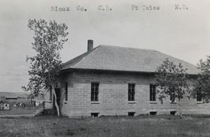
 Postcard. Historic Sioux County Courthouse at Fort Yates, North Dakota. | |
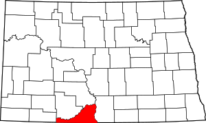
 الموقع ضمن ولاية North Dakota | |
 موقع North Dakota ضمن الولايات المتحدة | |
| الإحداثيات: 46°07′N 101°03′W / 46.11°N 101.05°W | |
| البلد | |
| State | |
| تأسست | September 3, 1914 (created) September 12, 1914 (organized) |
| السمِيْ | Sioux people |
| Seat | Fort Yates |
| Largest community | Cannon Ball |
| المساحة | |
| • الإجمالي | 1٬128 ميل² (2٬920 كم²) |
| • البر | 1٬094 ميل² (2٬830 كم²) |
| • الماء | 34 ميل² (90 كم²) 3.0% |
| التعداد (2010) | |
| • الإجمالي | 4٬153 |
| • Estimate (2019) | 4٬230 |
| • الكثافة | 3٫7/sq mi (1٫4/km2) |
| منطقة التوقيت | |
| (eastern portion) | UTC−6 (Central) |
| • الصيف (التوقيت الصيفي) | UTC−5 (CDT) |
| (western portion) | UTC−7 (Mountain) |
| • Summer (DST) | UTC−6 (MDT) |
سو إنگليزية: Sioux هي إحدى مقاطعات ولاية داكوتا الشمالية في الولايات المتحدة الأمريكية.
المقاطعات المجاورة
- Morton County - north (observes Central Time)
- Emmons County - east (observes Central Time)
- Corson County, South Dakota - south (observes Mountain Time)
- Adams County - west (observes Mountain Time)
- Grant County - northwest (observes Mountain Time)
Protected areas[1]
- Cedar River National Grassland (part)
- Froelich Dam State Game Management Area
Demographics
| التعداد التاريخي | |||
|---|---|---|---|
| التعداد | Pop. | %± | |
| 1920 | 3٬308 | — | |
| 1930 | 4٬687 | 41٫7% | |
| 1940 | 4٬419 | −5٫7% | |
| 1950 | 3٬696 | −16٫4% | |
| 1960 | 3٬662 | −0٫9% | |
| 1970 | 3٬632 | −0٫8% | |
| 1980 | 3٬620 | −0٫3% | |
| 1990 | 3٬761 | 3٫9% | |
| 2000 | 4٬044 | 7٫5% | |
| 2010 | 4٬153 | 2٫7% | |
| 2019 (تق.) | 4٬230 | [2] | 1٫9% |
| US Decennial Census[3] 1790-1960[4] 1900-1990[5] 1990-2000[6] 2010-2019[7] | |||
السياسة
With its population being mostly Native American, Sioux County is one of the most consistently Democratic counties in North Dakota, having last backed a Republican presidential candidate in 1980. In 2016, Hillary Clinton won the votes in Sioux County, one of only two counties she won in the state. Green Party candidate Jill Stein received 10.4% of the popular vote.[8]
Presidential election results
| Year | Republican | Democratic | Third parties |
|---|---|---|---|
| 2016 | 21.1% 260 | 61.5% 758 | 17.4% 214 |
| 2012 | 19.7% 225 | 78.7% 900 | 1.7% 19 |
| 2008 | 15.6% 215 | 83.1% 1,145 | 1.3% 18 |
| 2004 | 28.0% 319 | 70.5% 804 | 1.5% 17 |
| 2000 | 25.8% 269 | 69.6% 724 | 4.6% 48 |
| 1996 | 30.0% 207 | 57.0% 393 | 13.0% 90 |
| 1992 | 26.8% 264 | 47.1% 463 | 26.1% 257 |
| 1988 | 31.2% 325 | 67.3% 701 | 1.5% 16 |
| 1984 | 39.5% 442 | 58.6% 655 | 1.9% 21 |
| 1980 | 56.9% 620 | 35.1% 383 | 8.0% 87 |
| 1976 | 32.8% 354 | 64.5% 697 | 2.8% 30 |
| 1972 | 49.1% 561 | 48.8% 557 | 2.1% 24 |
| 1968 | 45.3% 482 | 49.3% 525 | 5.5% 58 |
| 1964 | 31.0% 314 | 68.6% 695 | 0.4% 4 |
| 1960 | 45.4% 571 | 54.7% 688 | |
| 1956 | 60.0% 718 | 39.8% 476 | 0.3% 3 |
| 1952 | 73.2% 968 | 25.4% 336 | 1.4% 18 |
| 1948 | 57.2% 667 | 39.9% 465 | 2.9% 34 |
| 1944 | 60.0% 673 | 39.7% 445 | 0.4% 4 |
| 1940 | 66.8% 1,167 | 33.1% 578 | 0.1% 1 |
| 1936 | 35.2% 585 | 52.7% 877 | 12.1% 202 |
| 1932 | 20.3% 350 | 77.1% 1,328 | 2.6% 44 |
| 1928 | 40.5% 687 | 58.2% 988 | 1.4% 23 |
| 1924 | 62.2% 777 | 4.6% 58 | 33.2% 414 |
| 1920 | 80.8% 776 | 17.0% 163 | 2.3% 22 |
| 1916 | 50.1% 232 | 43.2% 200 | 6.7% 31 |
See also
References
- ^ خطأ استشهاد: وسم
<ref>غير صحيح؛ لا نص تم توفيره للمراجع المسماةSCND - ^ "Population and Housing Unit Estimates". Retrieved April 2, 2020.
- ^ "US Decennial Census". US Census Bureau. Retrieved February 1, 2015.
- ^ "Historical Census Browser". University of Virginia Library. Retrieved February 1, 2015.
- ^ Forstall, Richard L., ed. (April 20, 1995). "Population of Counties by Decennial Census: 1900 to 1990". US Census Bureau. Retrieved February 1, 2015.
- ^ "Census 2000 PHC-T-4. Ranking Tables for Counties: 1990 and 2000" (PDF). US Census Bureau. April 2, 2001. Retrieved February 1, 2015.
- ^ خطأ استشهاد: وسم
<ref>غير صحيح؛ لا نص تم توفيره للمراجع المسماةQF - ^ أ ب Leip, David. "Atlas of US Presidential Elections". uselectionatlas.org. Retrieved April 13, 2018.
External links

|
Morton County | Grant County | 
| |
| Emmons County | Adams County | |||
| Corson County, South Dakota |
قالب:Sioux County, North Dakota
قالب:Midwestern U.S. majority-minority counties
46°07′N 101°03′W / 46.11°N 101.05°W{{#coordinates:}}: لا يمكن أن يكون هناك أكثر من وسم أساسي واحد لكل صفحة
تصنيفات:
- Pages using gadget WikiMiniAtlas
- صفحات ذات وسوم إحداثيات غير صحيحة
- Short description is different from Wikidata
- Coordinates on Wikidata
- مقاطعات North Dakota
- Pages using infobox U.S. county with unknown parameters
- Articles containing إنگليزية-language text
- Pages using Lang-xx templates
- Pages using US Census population needing update
- Sioux County, North Dakota
- North Dakota counties on the Missouri River
- 1914 establishments in North Dakota
- Populated places established in 1914
- Counties in multiple time zones
- مقاطعات داكوتا الشمالية
