مقاطعة باسيفيك، واشنطن
Pacific County | |
|---|---|
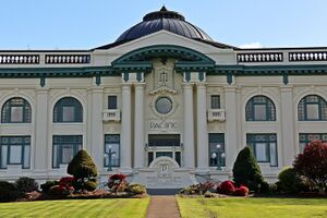
 Pacific County Courthouse, South Bend | |
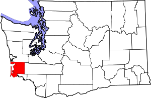
 الموقع ضمن ولاية Washington | |
 موقع Washington ضمن الولايات المتحدة | |
| الإحداثيات: 46°34′N 123°47′W / 46.56°N 123.78°W | |
| البلد | |
| State | |
| تأسست | February 4, 1851 |
| السمِيْ | Pacific Ocean |
| Seat | South Bend |
| Largest city | Raymond |
| المساحة | |
| • الإجمالي | 1٬223 ميل² (3٬170 كم²) |
| • البر | 933 ميل² (2٬420 كم²) |
| • الماء | 291 ميل² (750 كم²) 24%% |
| التعداد (2020) | |
| • الإجمالي | 23٬365 |
| • Estimate (2021) | 23٬948 ▲ |
| • الكثافة | 19/sq mi (7/km2) |
| منطقة التوقيت | UTC−8 (Pacific) |
| • الصيف (التوقيت الصيفي) | UTC−7 (PDT) |
| Congressional district | 3rd |
| الموقع الإلكتروني | www |
مقاطعة باسيفيك إنگليزية: Pacific County هي إحدى مقاطعات ولاية واشنطون في الولايات المتحدة الأمريكية. As of the 2020 census, the population was 23,365.[1] Its county seat is South Bend,[2] and its largest city is Raymond. The county was formed by the government of Oregon Territory in February 1851[3] and is named for the Pacific Ocean.
Pacific County is centered on Willapa Bay, a region that provides twenty-five percent of the United States oyster harvest,[4] although forestry, fishing, and tourism are also significant elements of the county's economy.
. . . . . . . . . . . . . . . . . . . . . . . . . . . . . . . . . . . . . . . . . . . . . . . . . . . . . . . . . . . . . . . . . . . . . . . . . . . . . . . . . . . . . . . . . . . . . . . . . . . . . . . . . . . . . . . . . . . . . . . . . . . . . . . . . . . . . . . . . . . . . . . . . . . . . . . . . . . . . . . . . . . . . . . .
التاريخ
The area that is now Pacific County was part of Oregon Territory in the first part of the nineteenth century. On December 19, 1845, the Provisional Government of Oregon created two counties (Vancouver and Clark) in its northern portion (which is now the state of Washington). In 1849, the name of Vancouver County was changed to Lewis County, and on February 4, 1851, a portion of Lewis County was partitioned off to become Pacific County. The county's boundaries have not changed since its creation. The unincorporated community of Oysterville, established in 1852, was the first county seat. The county records were stolen from Oysterville and ferried across Willapa Harbor by residents of South Bend, resulting in that town becoming the new county seat in 1893.
الجغرافيا
According to the United States Census Bureau, the county has an area of 1,223 square miles (3,170 km2), of which 933 square miles (2,420 km2) is land and 291 square miles (750 km2) (24%) is water.[5]
سمات جغرافية
Major highways
Adjacent counties
- Grays Harbor County – north
- Lewis County – east
- Wahkiakum County – southeast
- Clatsop County, Oregon – south
National protected areas
السكان
| التعداد التاريخي | |||
|---|---|---|---|
| التعداد | Pop. | %± | |
| 1860 | 420 | — | |
| 1870 | 738 | 75٫7% | |
| 1880 | 1٬645 | 122٫9% | |
| 1890 | 4٬358 | 164٫9% | |
| 1900 | 5٬983 | 37٫3% | |
| 1910 | 12٬532 | 109٫5% | |
| 1920 | 14٬891 | 18٫8% | |
| 1930 | 14٬970 | 0٫5% | |
| 1940 | 15٬928 | 6٫4% | |
| 1950 | 16٬558 | 4�0% | |
| 1960 | 14٬674 | −11٫4% | |
| 1970 | 15٬796 | 7٫6% | |
| 1980 | 17٬237 | 9٫1% | |
| 1990 | 18٬882 | 9٫5% | |
| 2000 | 20٬984 | 11٫1% | |
| 2010 | 20٬920 | −0٫3% | |
| 2020 | 23٬365 | 11٫7% | |
| 2021 (تق.) | 23٬948 | [6] | 2٫5% |
| U.S. Decennial Census[7] 1790–1960[8] 1900–1990[9] 1990–2000[10] 2010–2020[1] | |||
Politics
Pacific County, along with neighboring Grays Harbor County, has been one of the most consistently Democratic counties in the nation. In 2016, however, the county, like Grays Harbor County, broke its long streak of backing the Democratic candidate for president, voting for the Republican candidate, Donald Trump over Democrat Hillary Clinton.
| السنة | الجمهوري | الديمقراطي | حزب ثالث | |||
|---|---|---|---|---|---|---|
| رقم. | % | رقم. | % | رقم. | % | |
| 2020 | 6,953 | 49٫44% | 6,794 | 48٫31% | 317 | 2٫25% |
| 2016 | 5,360 | 48٫85% | 4,620 | 42٫11% | 992 | 9٫04% |
| 2012 | 4,499 | 42٫30% | 5,711 | 53٫69% | 426 | 4٫01% |
| 2008 | 4,555 | 41٫20% | 6,094 | 55٫12% | 406 | 3٫67% |
| 2004 | 4,634 | 44٫43% | 5,570 | 53٫40% | 227 | 2٫18% |
| 2000 | 4,042 | 42٫46% | 4,895 | 51٫42% | 582 | 6٫11% |
| 1996 | 2,598 | 28٫51% | 5,095 | 55٫92% | 1,418 | 15٫56% |
| 1992 | 2,243 | 24٫24% | 4,587 | 49٫58% | 2,422 | 26٫18% |
| 1988 | 3,073 | 37٫48% | 5,017 | 61٫18% | 110 | 1٫34% |
| 1984 | 3,613 | 42٫90% | 4,679 | 55٫56% | 129 | 1٫53% |
| 1980 | 3,132 | 39٫09% | 3,727 | 46٫52% | 1,153 | 14٫39% |
| 1976 | 2,781 | 37٫84% | 4,278 | 58٫20% | 291 | 3٫96% |
| 1972 | 3,349 | 46٫73% | 3,585 | 50٫03% | 232 | 3٫24% |
| 1968 | 2,491 | 37٫71% | 3,740 | 56٫62% | 374 | 5٫66% |
| 1964 | 1,789 | 26٫08% | 5,056 | 73٫70% | 15 | 0٫22% |
| 1960 | 3,224 | 45٫47% | 3,837 | 54٫12% | 29 | 0٫41% |
| 1956 | 3,799 | 49٫76% | 3,824 | 50٫09% | 12 | 0٫16% |
| 1952 | 3,846 | 50٫19% | 3,778 | 49٫30% | 39 | 0٫51% |
| 1948 | 2,749 | 38٫98% | 3,902 | 55٫33% | 401 | 5٫69% |
| 1944 | 2,419 | 39٫17% | 3,745 | 60٫64% | 12 | 0٫19% |
| 1940 | 2,704 | 37٫84% | 4,393 | 61٫48% | 48 | 0٫67% |
| 1936 | 1,732 | 26٫87% | 4,395 | 68٫17% | 320 | 4٫96% |
| 1932 | 1,737 | 31٫08% | 3,099 | 55٫46% | 752 | 13٫46% |
| 1928 | 3,247 | 67٫41% | 1,523 | 31٫62% | 47 | 0٫98% |
| 1924 | 2,672 | 64٫57% | 501 | 12٫11% | 965 | 23٫32% |
| 1920 | 2,607 | 65٫57% | 874 | 21٫98% | 495 | 12٫45% |
| 1916 | 2,688 | 59٫50% | 1,537 | 34٫02% | 293 | 6٫49% |
| 1912 | 1,375 | 33٫77% | 971 | 23٫85% | 1,726 | 42٫39% |
| 1908 | 1,492 | 69٫30% | 483 | 22٫43% | 178 | 8٫27% |
| 1904 | 1,354 | 76٫98% | 258 | 14٫67% | 147 | 8٫36% |
| 1900 | 887 | 66٫74% | 393 | 29٫57% | 49 | 3٫69% |
| 1896 | 925 | 61٫22% | 562 | 37٫19% | 24 | 1٫59% |
| 1892 | 759 | 52٫60% | 559 | 38٫74% | 125 | 8٫66% |
. . . . . . . . . . . . . . . . . . . . . . . . . . . . . . . . . . . . . . . . . . . . . . . . . . . . . . . . . . . . . . . . . . . . . . . . . . . . . . . . . . . . . . . . . . . . . . . . . . . . . . . . . . . . . . . . . . . . . . . . . . . . . . . . . . . . . . . . . . . . . . . . . . . . . . . . . . . . . . . . . . . . . . . .
Communities
Cities
- Ilwaco
- Long Beach
- Raymond
- South Bend (county seat)
Census-designated places
Unincorporated communities
See also
- Ilwaco Railway and Navigation Company
- National Register of Historic Places listings in Pacific County, Washington
- Steamboats of Willapa Bay
- Astoria-Megler Ferry
References
- ^ أ ب "State & County QuickFacts". United States Census Bureau. Retrieved أبريل 8, 2022.
- ^ "Find a County". National Association of Counties. Retrieved يونيو 7, 2011.
- ^ "Milestones for Washington State History — Part 2: 1851 to 1900". HistoryLink.org. مارس 6, 2003.
- ^ Chinook Observer, The Willapa Bay Oyster Industry: Shellfish is still No. 1 [1]
- ^ "2010 Census Gazetteer Files". United States Census Bureau. أغسطس 22, 2012. Retrieved يوليو 7, 2015.
- ^ "Annual Estimates of the Resident Population for Counties: April 1, 2020 to July 1, 2021". Retrieved أبريل 8, 2022.
- ^ "U.S. Decennial Census". United States Census Bureau. Retrieved يناير 7, 2014.
- ^ "Historical Census Browser". University of Virginia Library. Retrieved يناير 7, 2014.
- ^ "Population of Counties by Decennial Census: 1900 to 1990". United States Census Bureau. Retrieved يناير 7, 2014.
- ^ "Census 2000 PHC-T-4. Ranking Tables for Counties: 1990 and 2000" (PDF). United States Census Bureau. Archived from the original (PDF) on فبراير 26, 2015. Retrieved يناير 7, 2014.
- ^ Leip, David. "Dave Leip's Atlas of U.S. Presidential Elections". uselectionatlas.org. Retrieved أبريل 10, 2018.
- ^ The leading "other" candidate, Progressive Theodore Roosevelt, received 1,251 votes, while Socialist candidate Eugene Debs received 382 votes, Prohibition candidate Eugene Chafin received 82 votes, and Socialist Labor candidate Arthur Reimer received 11 votes.
External links
 Media related to Pacific County, Washington at Wikimedia Commons

|
Grays Harbor County | 
| ||
| Lewis County | Pacific Ocean | |||
| Wahkiakum County | Clatsop County, Oregon |
- Pages using gadget WikiMiniAtlas
- Short description is different from Wikidata
- Use mdy dates from December 2018
- Coordinates on Wikidata
- Washington (state) counties
- Pages using infobox U.S. county with unknown parameters
- Articles containing إنگليزية-language text
- Pages using Lang-xx templates
- Pacific County, Washington
- 1851 establishments in Oregon Territory
- Populated places established in 1851
- Western Washington
- مقاطعات ولاية واشنطن الأمريكية