مقاطعة أوكلاند، مشيگن
Oakland County, Michigan | |
|---|---|
| County of Oakland | |
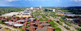
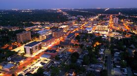
Top-to-bottom, left-to-right: Troy's skyline, Southfield's skyline, Rackham Fountain (at the Detroit Zoo), National Shrine of the Little Flower Basilica (Royal Oak), Downtown Pontiac, Downtown Royal Oak (downtown Detroit on the horizon) | |
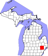 Location within the state of Michigan | |
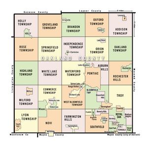
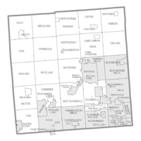 Cities and Townships in the county | |
| Country | United States |
| State | Michigan |
| Metro | Metro Detroit |
| Incorporated | 1819 (created) 1820 (organized)[1][2] |
| County seat | Pontiac / Waterford |
| Largest city | |
| الحكومة | |
| • Executive | David Coulter (D) |
| المساحة | |
| • الإجمالي | 907 ميل² (2٬350 كم²) |
| • البر | 868 ميل² (2٬250 كم²) |
| • الماء | 40 ميل² (100 كم²) |
| التعداد (2020) | |
| • الإجمالي | 1٬274٬395 |
| • الكثافة | 1٬486/sq mi (574/km2) |
| GDP | |
| • Total | $124.285 billion (2022) |
| منطقة التوقيت | UTC−5 (Eastern Time Zone) |
| • الصيف (التوقيت الصيفي) | UTC−4 (Eastern Daylight Time) |
| Area codes | 248 and 947 |
| الموقع الإلكتروني | www |
مقاطعة أوكلاند (بالإنجليزية: Oakland County)، هي مقاطعة بولاية مشيگن، الولايات المتحدة. أشهر مدنها پونتياك. It is a principal county of the Detroit metropolitan area, containing the bulk of Detroit's northern suburbs. Its county seat is Pontiac, and its largest city is Troy.[4] As of the 2020 Census, its population was 1,274,395,[5] making it the second-most populous county in Michigan (behind neighboring Wayne County), and the largest county in the United States without a city of 100,000 residents.
Founded in 1819 and organized in 1820,[1][6] Oakland County is composed of 62 cities, villages, and townships. In 2010, Oakland County was among the ten wealthiest counties in the United States to have over one million residents.[7] It is also home to Oakland University, a large public institution that straddles the border between the cities of Auburn Hills and Rochester Hills.
. . . . . . . . . . . . . . . . . . . . . . . . . . . . . . . . . . . . . . . . . . . . . . . . . . . . . . . . . . . . . . . . . . . . . . . . . . . . . . . . . . . . . . . . . . . . . . . . . . . . . . . . . . . . . . . . . . . . . . . . . . . . . . . . . . . . . . . . . . . . . . . . . . . . . . . . . . . . . . . . . . . . . . . .
التاريخ
Founded by Territorial Governor Lewis Cass in 1819, sparsely settled Oakland was originally twice its current size. As was customary at the time, as populations increased, other counties were organized from its land area. Woodward Avenue and the Detroit and Pontiac Railroad helped draw settlers in the 1840s. By 1840, Oakland had more than fifty lumber mills, processing wood harvested from the region and the Upper Peninsula. Pontiac, located on the Clinton River, was Oakland's first town and became the county seat. After the Civil War, Oakland was still primarily a rural, agricultural county with numerous isolated villages. By the end of the 19th century, three rail lines served Pontiac, and the city attracted carriage and wagon factories. In the late 1890s streetcars were constructed here and to Detroit.[بحاجة لمصدر]
At that time, developers made southern Oakland County a suburb of Detroit; a Cincinnati firm platted a section of Royal Oak called "Urbanrest." Migration worked both ways. Several thousand people moved from Oakland County farms to Detroit as the city attracted factories. By 1910, a number of rich Detroiters had summer homes and some year-round residences in what became Bloomfield Hills. The auto age enveloped Pontiac in the early 1900s. The Oakland Motor Car Company was founded in 1907 and became a part of General Motors Corp., which was soon Pontiac's dominant firm.[8]
In the 1950s, Oakland County's population boomed as the Detroiters began migrating to the suburbs. While the neighboring Macomb County was more inhabited by auto workers and other blue-collar workers, Oakland County's residents tended to be more affluent and generally white-collar (e.g. doctors, lawyers).[9] Oakland County was for a time the fourth-wealthiest county in the United States, though its position has declined somewhat since the Great Recession.[10] The median price of a home in Oakland County increased to $164,697, more than $30,000 above the national median. Oakland County is home to several super-regional shopping malls such as Oakland Mall, Somerset Collection, Twelve Oaks Mall, and Great Lakes Crossing Outlets.
الجغرافيا
حسب مكتب الإحصاء الأمريكي، مساحة مقاطعة أوكلاند 2,352 كم²، 2260 كم² منها يمثل اليابسة، بينما 92 كم² يمثل المياه. النسبة الإجمالية للمياه هي 3.91%.[11]
Oakland County was originally divided into 25 separate townships, which are listed below. Each township is roughly equal in size at six miles (9.7 km) by six miles, for a total township area of 36 square miles (93 km2). The roots of this design were born out of the Land Ordinance of 1785 and the subsequent Northwest Ordinance of 1787. Oakland County itself is a prime example of the land policy that was established, as all townships are equal in size (save for slight variations due to waterways). Section 16 in each township was reserved for financing and maintaining public education, and even today many schools in Oakland County townships are located within that section.
تقع مقاطعة وين، حيث توجد مدينة ديترويت، جنوب مقاطعة أوكلاند. 8 Mile Road, also known as "Baseline Road" in some areas, is the boundary between these counties. The baseline was used during the original surveying for Michigan, and it serves as the northern/southern boundaries for counties from Lake St. Clair to Lake Michigan. As more working and middle-class populations moved to the suburbs from the 1950s on, this divide (8 Mile Road) became historically known as an unofficial racial dividing line between what became the predominantly black city and almost exclusively white suburbs.
Since the late 20th century, however, the patterns of de facto segregation have faded as the suburbs have become more diverse. Middle-class African Americans have left Detroit, settling in inner-ring suburbs, notably Southfield (where the population is 75% Black), west of Woodward Avenue. Based on the 2010 Census, the following cities also have significant non-white populations: Farmington (25.3%), Farmington Hills (31.7%), Novi (30.12%), Oak Park (62.61%), Lathrup Village (72.97%), Orchard Lake Village (16.08%), Rochester Hills (20.94%), Troy (29.4%), Wixom (26.28%), West Bloomfield (24.0%), Bloomfield (18.28%), Bloomfield Hills (14.2%), Ferndale (17.2%), and Madison Heights (17.7%). Ferndale has a concentration of Arab Americans, who also live in nearby areas, and numerous Asian Americans, particularly Indians, have also settled in these areas.
المقاطعات المجاورة
- مقاطعة ماكومب (الشرق)
- مقاطعة ليڤينگستون (الغرب)
- مقاطعة وين (الجنوب الشرقي)
- مقاطعة واشتيناو (الجنوب الغربي)
- مقاطعة لابير (الشمال الشرقي)
- مقاطعة جينيسي (الشمال الغربي)
الأنهار والبحيرات
Oakland County contains 387 lakes, and four major rivers run through the county:[12]
The headwaters of each of these rivers lie in Oakland County.
التجمعات
المدن
- أوبرن هيلز
- أورتشارد ليك ڤلدج
- أوك بارك
- بلومفيلد هيلز
- پليزنت ردج
- پونتياك
- بركلي
- برمنگهام
- تروي
- جنوب ليون
- روتشستر
- روتشستر هيلز
- رويال أوك
- ساوثفيلد
- سيلڤان ليك
- فارمنگتون
- فارمنگتون هيلز
- فيرنديل
- كلاركستون
- كلاوسن
- كيگو هاربر
- لاثروپ ڤلدج
- ليك أنجيلس
- ماديسون هايتس
- نورثفل
- نوڤي
- هازل بارك
- هنتنگتون وودز
- وولد ليك
- ويكسوم
القرى
بلديات بميثاق
- Bloomfield Charter Township
- Brandon Charter Township
- Commerce Charter Township
- Highland Charter Township
- Independence Charter Township
- Lyon Charter Township
- Milford Charter Township
- Oakland Charter Township
- Orion Charter Township
- Oxford Charter Township
- Royal Oak Charter Township
- Springfield Charter Township
- Waterford Charter Township
- West Bloomfield Charter Township
- White Lake Charter Township
Civil townships
Unincorporated communities
- Andersonville
- Austin Corners
- Brandon Gardens
- Campbells Corner
- Charing Cross
- Clintonville
- Clyde
- Commerce
- Davisburg
- Drayton Plains
- East Highland
- Elizabeth Lake
- Five Points
- Four Towns
- Gingellville
- Glengary
- Goodison
- Groveland Corners
- Hickory Ridge
- Highland
- Huron Heights
- Jossman Acres
- Kensington
- Lake Orion Heights
- Lakeville
- New Hudson
- Newark
- Oak Grove
- Oakley Park
- Oakwood
- Oxbow
- Perry Lake Heights
- Rose Center
- Rose Corners
- Rudds Mill
- Seven Harbors
- Springfield
- Thomas
- Union Lake
- Walters
- Waterford Village
- Waterstone
- West Highland
- Westacres
- White Lake
السكان
| التعداد التاريخي | |||
|---|---|---|---|
| التعداد | Pop. | %± | |
| 1820 | 330 | — | |
| 1830 | 4٬911 | 1٬388٫2% | |
| 1840 | 23٬646 | 381٫5% | |
| 1850 | 31٬270 | 32٫2% | |
| 1860 | 38٬261 | 22٫4% | |
| 1870 | 40٬867 | 6٫8% | |
| 1880 | 41٬537 | 1٫6% | |
| 1890 | 41٬245 | −0٫7% | |
| 1900 | 44٬792 | 8٫6% | |
| 1910 | 49٬576 | 10٫7% | |
| 1920 | 90٬050 | 81٫6% | |
| 1930 | 211٬251 | 134٫6% | |
| 1940 | 254٬068 | 20٫3% | |
| 1950 | 396٬001 | 55٫9% | |
| 1960 | 690٬259 | 74٫3% | |
| 1970 | 907٬871 | 31٫5% | |
| 1980 | 1٬011٬793 | 11٫4% | |
| 1990 | 1٬083٬592 | 7٫1% | |
| 2000 | 1٬194٬156 | 10٫2% | |
| 2010 | 1٬202٬362 | 0٫7% | |
| 2020 | 1٬274٬395 | 6�0% | |
| U.S. Decennial Census[13] 1790–1960[14] 1900–1990[15] 1990–2000[16] 2010–2019[5] | |||
As of the 2010 Census, there were 1,202,362 people and 315,175 families residing in the county. 77.3% were White, 13.6% Black or African American, 5.6% Asian, 0.3% Native American, 1.0% of some other race and 2.2% of two or more races. 3.5% were Hispanic or Latino (of any race). There were 527,255 housing units at an average density of 564 units per square mile (218 units/km2).[17]
Regarding ancestry, in 2000 14.4% of the population were ethnically German, 9.0% Irish, 8.5% English, 8.5% Polish, 5.7% Italian and 5.5% American, 87.4% spoke only English at home; 2.0% spoke Spanish, 1.3% Syriac (Neo Aramaic) and 1.0% Arabic. The population density as of the 2000 census was 1,369 people per square mile (529 people/km2). There were 492,006 housing units at an average density of 564 units per square mile (218 units/km2).
The 2000 census showed two Native American tribes with more than 1,000 members in Oakland County. There were 2,095 Cherokee and 1,458 Chippewa.
The Jewish community of metropolitan Detroit, with a population of 72,000, is the 21st largest Jewish community in the nation. This community is concentrated in Oakland County, especially in Southfield, Oak Park, West Bloomfield, Bloomfield Hills, Farmington Hills, Troy and Huntington Woods.[18]
There were 471,115 households, of which 32.40% had children under the age of 18 living with them. 54.20% were married couples living together, 9.50% had a female householder with no husband present, and 33.10% were non-families. 27.30% of all households were made up of individuals, and 8.50% had someone living alone who was 65 years of age or older. The average household size was 2.51 and the average family size was 3.09.
Among Asian Americans, eight ethnic groups had more than 1,000 members in the county in 2000. The most numerous were those of Asian Indian descent, with 20,705. Next were those of Chinese heritage, numbering 10,018. Next were those of Japanese (5,589), Filipino (5,450) Korean (5,351), Vietnamese (1,687), Pakistani (1,458) and Hmong (1,210) ancestry.[19]
In 2001, Oakland County had the 36th largest Asian population of any county in the country.[20] In 2002, of the Oakland-Wayne-Macomb tricounty area, Oakland County had 49% of the tri-county area's Asian population.[21]
In terms of age, 25.20% of the county's population was under the age of 18, 7.20% from 18 to 24, 32.40% from 25 to 44, 23.90% from 45 to 64, and 11.30% was 65 years of age or older. The median age was 37 years. For every 100 females, there were 95.90 males. For every 100 females age 18 and over, there were 92.70 males.
The median income for a household in the county was $86,567, making Oakland County the 71st wealthiest county in the United States.[22] Males had a median income of $55,833 versus $35,890 for females. The per capita income for the county was $65,759. About 3.80% of families and 5.50% of the population were below the poverty line, including 6.50% of those under age 18 and 6.50% of those age 65 or over.
. . . . . . . . . . . . . . . . . . . . . . . . . . . . . . . . . . . . . . . . . . . . . . . . . . . . . . . . . . . . . . . . . . . . . . . . . . . . . . . . . . . . . . . . . . . . . . . . . . . . . . . . . . . . . . . . . . . . . . . . . . . . . . . . . . . . . . . . . . . . . . . . . . . . . . . . . . . . . . . . . . . . . . . .
السياسة
| السنة | الجمهوري | الديمقراطي | حزب ثالث | |||
|---|---|---|---|---|---|---|
| رقم. | % | رقم. | % | رقم. | % | |
| 2020 | 325,971 | 42٫22% | 434,148 | 56٫24% | 11,872 | 1٫54% |
| 2016 | 289,203 | 43٫23% | 343,070 | 51٫29% | 36,652 | 5٫48% |
| 2012 | 296,514 | 45٫37% | 349,002 | 53٫40% | 8,055 | 1٫23% |
| 2008 | 276,956 | 41٫94% | 372,566 | 56٫42% | 10,873 | 1٫65% |
| 2004 | 316,633 | 49٫32% | 319,387 | 49٫75% | 5,957 | 0٫93% |
| 2000 | 274,319 | 48٫10% | 281,201 | 49٫31% | 14,745 | 2٫59% |
| 1996 | 219,855 | 43٫48% | 241,884 | 47٫84% | 43,903 | 8٫68% |
| 1992 | 242,160 | 43٫57% | 214,733 | 38٫64% | 98,867 | 17٫79% |
| 1988 | 283,359 | 61٫27% | 174,745 | 37٫78% | 4,384 | 0٫95% |
| 1984 | 306,050 | 66٫71% | 150,286 | 32٫76% | 2,464 | 0٫54% |
| 1980 | 253,211 | 54٫65% | 164,869 | 35٫58% | 45,248 | 9٫77% |
| 1976 | 244,271 | 58٫69% | 164,266 | 39٫47% | 7,668 | 1٫84% |
| 1972 | 241,613 | 63٫78% | 129,400 | 34٫16% | 7,838 | 2٫07% |
| 1968 | 156,538 | 45٫31% | 154,630 | 44٫76% | 34,290 | 9٫93% |
| 1964 | 114,025 | 38٫33% | 182,797 | 61٫44% | 686 | 0٫23% |
| 1960 | 162,026 | 54٫27% | 135,531 | 45٫39% | 1,005 | 0٫34% |
| 1956 | 152,990 | 60٫37% | 99,901 | 39٫42% | 527 | 0٫21% |
| 1952 | 115,503 | 60٫73% | 73,871 | 38٫84% | 805 | 0٫42% |
| 1948 | 62,516 | 53٫49% | 51,491 | 44٫06% | 2,859 | 2٫45% |
| 1944 | 59,627 | 51٫49% | 55,272 | 47٫73% | 914 | 0٫79% |
| 1940 | 49,002 | 50٫71% | 47,022 | 48٫67% | 599 | 0٫62% |
| 1936 | 30,071 | 40٫64% | 40,329 | 54٫50% | 3,597 | 4٫86% |
| 1932 | 32,462 | 47٫79% | 33,135 | 48٫78% | 2,331 | 3٫43% |
| 1928 | 45,343 | 81٫53% | 10,011 | 18�00% | 264 | 0٫47% |
| 1924 | 28,603 | 81٫27% | 4,105 | 11٫66% | 2,488 | 7٫07% |
| 1920 | 19,321 | 70٫98% | 6,421 | 23٫59% | 1,478 | 5٫43% |
| 1916 | 7,730 | 51٫86% | 6,659 | 44٫67% | 517 | 3٫47% |
| 1912 | 4,083 | 35٫46% | 3,668 | 31٫86% | 3,762 | 32٫68% |
| 1908 | 6,267 | 58٫18% | 3,950 | 36٫67% | 554 | 5٫14% |
| 1904 | 6,986 | 61٫88% | 3,956 | 35٫04% | 347 | 3٫07% |
| 1900 | 6,173 | 53٫04% | 4,966 | 42٫67% | 499 | 4٫29% |
| 1896 | 5,846 | 46٫01% | 5,271 | 41٫49% | 1,588 | 12٫50% |
| 1892 | 4,763 | 44٫98% | 4,925 | 46٫51% | 902 | 8٫52% |
| 1888 | 5,389 | 47٫31% | 5,410 | 47٫50% | 591 | 5٫19% |
| 1884 | 4,842 | 45٫03% | 5,386 | 50٫09% | 525 | 4٫88% |
Oakland County was historically a bastion of suburban conservatism, and was hence a longstanding stronghold of the Republican Party. However, in the 1990s it became highly competitive, and since 2008 it has increasingly shifted Democratic, giving over 50% of its votes to the Democratic candidate for president in each election. Republican strength is concentrated in the many exurban townships of the county, while Democratic strength is concentrated in suburbs such as Royal Oak, Farmington Hills, West Bloomfield, and Southfield. Some suburbs, such as Novi, Troy, Birmingham, and Rochester, were historically strongly Republican but are now relatively split between the two parties, with younger adults tending to support Democrats and older residents tending to support Republicans.
In 1996, Bill Clinton became the first Democrat to carry Oakland County since Lyndon Johnson in 1964, and only the fourth to do so since 1892. Al Gore and John Kerry also carried the county, by narrow margins of less than 7,000 and 3,000 votes respectively, against George W. Bush in 2000 and 2004, respectively. In 2008, the county swung significantly to Barack Obama, who became the first Democrat to win a majority in the county since LBJ, and only the third to do so since 1884. (See table at right.) He again carried the county in 2012, though by a smaller margin. Hillary Clinton won a narrow majority in 2016. In 2020, Joe Biden won 56 percent of the vote. He received over 400,000 votes, and became the first Democrat to carry the county by a margin of over 100,000 votes.
While the Democratic Party has found increasing success in presidential elections in Oakland County, the state Republican Party has remained strong in some recent gubernatorial and state elections. The county favored Republican Rick Snyder by a 22-point margin in the 2010 Michigan gubernatorial election and again by a 12-point margin in the 2014 election; conversely, the county favored Democratic candidate Gretchen Whitmer by a 17-point margin in the 2018 election and again by a 23-point margin in the 2022 election. Republicans held a majority on the County Commission for most of its history, but following the 2018 elections, Democrats won a narrow 11-10 majority on the commission.[24]
In the 118th Congress, Oakland County is represented by four Democrats: Debbie Dingell (6th), Elissa Slotkin (7th), Haley Stevens (11th), and Rashida Tlaib (12th) and two Republicans: John James (10th) and Lisa McClain (9th).
انظر أيضاً
- Woodward Corridor
- National Register of Historic Places listings in Oakland County, Michigan
- List of Michigan State Historic Sites in Oakland County, Michigan
- Oakland County Child Killer
- Saginaw Trail
الهامش
- ^ أ ب "Bibliography on Oakland County". Clarke Historical Library, Central Michigan University. Archived from the original on October 6, 2014. Retrieved January 29, 2013.
- ^ "History of Oakland County," OaklandWeb.com. Archived يوليو 5, 2006 at the Wayback Machine Retrieved February 7, 2007.
- ^ "Gross Domestic Product: All Industries in Oakland County, MI". fred.stlouisfed.org.
- ^ "Find a County". National Association of Counties. Archived from the original on May 31, 2011. Retrieved June 7, 2011.
- ^ أ ب "State & County QuickFacts". United States Census Bureau. Retrieved September 15, 2021.
- ^ History of Oakland County, Michigan. Philadelphia: L. H. Everts and Co. 1877. p. 23. Archived from the original on November 20, 2015. Retrieved October 4, 2014.
- ^ "Detroit Regional Chamber of Commerce - quick facts". detroitchamber.com. Archived from the original on October 10, 2012. Retrieved April 29, 2018.
- ^ Razmerita, Adriana (2022-09-26). "The True Meaning Behind The Pontiac Logo". HotCars (in الإنجليزية الأمريكية). Retrieved 2022-10-10.
- ^ "Macomb County politics in a class by itself — for weirdness". The Blade (in الإنجليزية). Retrieved 2023-07-13.
- ^ WOLFFE, JERRY. "Oakland plummets on list of wealthy counties". The Oakland Press (in الإنجليزية). Retrieved December 7, 2020.
- ^ "2010 Census Gazetteer Files". United States Census Bureau. August 22, 2012. Archived from the original on November 13, 2013. Retrieved September 27, 2014.
- ^ "Oakland County, Michigan". oakgov.com. Archived from the original on July 22, 2016. Retrieved June 28, 2016.
- ^ "U.S. Decennial Census". United States Census Bureau. Retrieved September 27, 2014.
- ^ "Historical Census Browser". University of Virginia Library. Archived from the original on August 11, 2012. Retrieved September 27, 2014.
- ^ "Population of Counties by Decennial Census: 1900 to 1990". United States Census Bureau. Archived from the original on February 15, 2015. Retrieved September 27, 2014.
- ^ "Census 2000 PHC-T-4. Ranking Tables for Counties: 1990 and 2000" (PDF). United States Census Bureau. Archived (PDF) from the original on December 18, 2014. Retrieved September 27, 2014.
- ^ "Oakland County QuickFacts from the US Census Bureau". Archived from the original on July 14, 2011. Retrieved July 6, 2012.
- ^ "Community Relations - Detroit?s Jewish Community | Jewish Community Council of Metropolitan Detroit". Archived from the original on July 25, 2011. Retrieved August 4, 2009.
- ^ See search results from United States Census Bureau. Retrieved July 2, 2007.
- ^ Metzger, Kurt and Jason Booza. "Asians in the United States, Michigan and Metropolitan Detroit Archived نوفمبر 9, 2013 at the Wayback Machine." Wayne State University Center for Urban Studies-January 2001 Working Paper Series, No. 7, p. 5. Retrieved on September 8, 2013.
- ^ Metzger, Kurt and Jason Booza. "Asians in the United States, Michigan and Metropolitan Detroit Archived نوفمبر 9, 2013 at the Wayback Machine." Center for Urban Studies, Wayne State University. January 2002 Working Paper Series, No. 7. p. 7. Retrieved on November 6, 2013.
- ^ "Richest Counties In The United States". WorldAtlas (in الإنجليزية الأمريكية). April 25, 2017. Retrieved December 7, 2020.
- ^ Leip, David. "Dave Leip's Atlas of U.S. Presidential Elections". uselectionatlas.org. Archived from the original on March 23, 2018. Retrieved April 29, 2018.
- ^ Cavitt, Mark (November 7, 2018). "Oakland County Board of Commissioners majority Democratic for third time in history". The Oakland Press. Retrieved March 30, 2019.
. . . . . . . . . . . . . . . . . . . . . . . . . . . . . . . . . . . . . . . . . . . . . . . . . . . . . . . . . . . . . . . . . . . . . . . . . . . . . . . . . . . . . . . . . . . . . . . . . . . . . . . . . . . . . . . . . . . . . . . . . . . . . . . . . . . . . . . . . . . . . . . . . . . . . . . . . . . . . . . . . . . . . . . .
للاستزادة
- Samuel W. Durant, History of Oakland County, Michigan: With Illustrations Descriptive of Its Scenery, Palatial Residences, Public Buildings, Fine Blocks, and Important Manufactories, From Original Sketches by Artists of the Highest Ability. Philadelphia: L.H. Everts and Co., 1877.
- Thaddeus DeWitt Seeley, History of Oakland County Michigan: A Narrative Account of Its Historic Progress, Its People, and Its Principal Interests. In Two Volumes. Chicago: Lewis Publishing Co., 1912. Volume 1 | Volume 2
وصلات خارجية
- Oakland County Government official website
- Map of Oakland County
- The Road Commission for Oakland County
- An Account of Oakland County edited by Lillian Drake Avery. Dayton, Ohio: National Historical Association, Inc., [1925?]
- "Bibliography on Oakland County". Clarke Historical Library, Central Michigan University. Retrieved January 29, 2013.
- Automation Alley
- CS1 الإنجليزية الأمريكية-language sources (en-us)
- Pages using gadget WikiMiniAtlas
- Short description is different from Wikidata
- Pages using multiple image with auto scaled images
- Pages using infobox settlement with no coordinates
- Articles with hatnote templates targeting a nonexistent page
- Articles with unsourced statements from December 2016
- Coordinates on Wikidata
- مقاطعات مشيگن
- مقاطعة اوكلاند، مشيگن
- دترويت الكبرى
- تأسيسات 1820 في أراضي مشيگن
- أماكن مأهولة تأسست في 1820
