مسميات الوحدات الإقليمية بالإحصاء
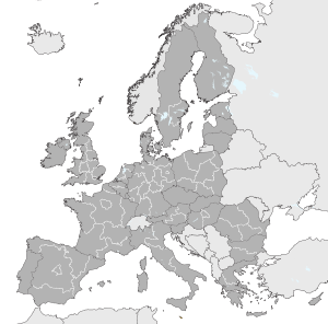
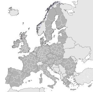
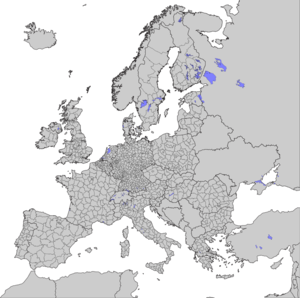
مسميات الوحدات الإقليمية بالإحصاء Nomenclature of Territorial Units for Statistics[1][2] or المسميات الإحصائية للوحدات الإقليمية[3][4][5][6] (NUTS[1][2][3][4][5][6][7][8][9][10] بالفرنسية Nomenclature des unités territoriales statistiques)، هي معيار ترميز جغرافي للرجوع إلى تقسيمات البلدان لأغراض إحصائية. هذا المعيار قام الاتحاد الأوروپي بتطويره وتنظيمه، وأصبح يغطي فقد أعضاء الاتحاد الأوروپي بالتفصيل. لمسميات الوحدات الإقليمية بالإحصاء دور فعال في آليات تنفيذ صندوق الهيكلة الأوروپي.
. . . . . . . . . . . . . . . . . . . . . . . . . . . . . . . . . . . . . . . . . . . . . . . . . . . . . . . . . . . . . . . . . . . . . . . . . . . . . . . . . . . . . . . . . . . . . . . . . . . . . . . . . . . . . . . . . . . . . . . . . . . . . . . . . . . . . . . . . . . . . . . . . . . . . . . . . . . . . . . . . . . . . . . .
المستويات
يوجد ثلاث مستويات معرفة من مسميات الوحدات الإقليمية بالإحصاء، بالإضافة إلى مستويين محليين أصغر. كان يطلق عليهم مسميات الوحدات الإقليمية الإحصائية من المستوى الرابع والخامس، حتى يوليو 2003، لكن تم إلغائهم رسمياً، بالرغم من أنه لا زالوا يستخدموا في بعض الأحيان. لاحظ أن جميع البلدان لديها مستوى تقسيم، يعتمد على حجمها.
| البلدان | NUTS 1 | NUTS 2 | NUTS 3 | ||||
|---|---|---|---|---|---|---|---|
| أعضاء الاتحاد الأوروپي | 27 | 97 | 271 | 1303 | |||
| النمسا | AT | Groups of states | 3 | States | 9 | Groups of districts | 35 |
| بلجيكا | BE | Regions | 3 | Provinces (+ بروكسل) | 11 | Arrondissements (Verviers split into two) | 44 |
| بلغاريا | BG | Regions | 2 | Planning regions | 6 | Oblasts | 28 |
| قبرص | CY | — | 1 | — | 1 | — | 1 |
| التشيك | CZ | — | 1 | اوبلستات | 8 | Regions | 14 |
| ألمانيا | DE | الولايات | 16 | Government regions (or equivalent) | 39 | Districts | 429 |
| الدنمارك | DK | — | 1 | Regions | 5 | الأراضي | 11 |
| إستونيا | EE | — | 1 | — | 1 | Groups of counties | 5 |
| إسپانيا | ES | مجموعات الحكم الذاتي | 7 | 17 15 منطقة حكم ذاتي ومدينتان حكم ذاتي | 19 | المقاطعات + الجزر + سبتة ومليلة | 59 |
| فنلندا | FI | Mainland Finland, Åland | 2 | المناقط الكبرى | 5 | Regions | 20 |
| فرنسا | FR | Z.E.A.T. + DOM | 9 | المناطق + DOM | 27 | الأقاليم + DOM | 101 |
| اليونان | GR | Groups of development regions | 4 | المناطق | 13 | الأقاليم | 51 |
| المجر | HU | المناطق الإحصائية الكبرى | 3 | Planning and statistical regions | 7 | Counties + بوداپشت | 20 |
| أيرلندا | IE | — | 1 | Regional Assemblies | 2 | Regional Authorities | 8 |
| إيطاليا | IT | مجموعات المناطق | 5 | Regions (Trentino-Alto Adige/Südtirol split into two) | 21 | Provinces | 107 |
| لتوانيا | LT | — | 1 | — | 1 | Counties | 10 |
| لوكسمبورگ | LU | — | 1 | — | 1 | — | 1 |
| لاتڤيا | LV | — | 1 | — | 1 | الأقاليم الإحصائية | 6 |
| مالطا | MT | — | 1 | — | 1 | الجزر | 2 |
| هولندا | NL | Groups of provinces | 4 | Provinces | 12 | COROP regions | 40 |
| پولندا | PL | الأقاليم | 6 | Voivodeships | 16 | Subregions | 66 |
| الپرتغال | PT | Continent (+ Azores and Madeira) | 3 | Regional Coordination Commissions + Autonomous regions | 7 | مجموعة البلديات | 30 |
| رومانيا | RO | Macroregions | 4 | Regions | 8 | Counties + بوخارست | 42 |
| السويد | SE | الأقاليم | 3 | المناطق الوطنية | 8 | المقاطعات | 21 |
| سلوڤنيا | SI | — | 1 | Macroregions | 2 | Statistical regions | 12 |
| سلوڤاكيا | SK | — | 1 | اوبلاستات | 4 | Regions | 8 |
| المملكة المتحدة | UK | Regions of England | 9 | Counties (some grouped); Inner and Outer London | 30 | Upper tier authorities or groups of lower tier authorities (unitary authorities or districts) | 93 |
| ويلز | 1 | Groups of unitary authorities | 2 | Groups of unitary authorities | 12 | ||
| إسكتلندا | 1 | Groups of unitary authorities or districts | 4 | Groups of unitary authorities or districts | 23 | ||
| أيرلندا الشمالية | 1 | — | 1 | Groups of districts | 5 | ||
| Acceding country | 1 | 1 | 2 | 21 | |||
| كرواتيا | HR | — | 1 | المناطق | 2 | Counties | 21 |
| البلدان المرشحة | 5 | 14 | 34 | 121 | |||
| أيسلندا | IS | — | 1 | — | 1 | منطقة العاصمة / بقية البلد | 2 |
| مقدونيا | MK | — | 1 | — | 1 | المناطق الإحصائية | 8 |
| الجبل الأسود | ME | — | 1 | — | 1 | — | 1 |
| صربيا | RS | مجموعات الأقاليم | 2 | المناطق | 5 | Districts | 29 |
| تركيا | TR | المناطق | 12 | الأقاليم | 26 | المحافظات | 81 |
| بلدان الاتحاد الأوروپي للتجارة الحرة | 3 | 3 | 15 | 46 | |||
| ليختنشتين | LI | — | 1 | — | 1 | — | 1 |
| النرويج | NO | — | 1 | المناطق | 7 | Counties | 19 |
| سويسرا | CH | — | 1 | المناطق | 7 | كانتونات | 26 |
التأسيس
| المستوى | الصغرى | الكبرى |
|---|---|---|
| مسميات الوحدات الإقليمية بالإحصاء 1 | 3 مليون | 7 مليون |
| مسميات الوحدات الإقليمية بالإحصاء 2 | 800,000 | 3 مليون |
| مسميات الوحدات الإقليمية بالإحصاء 3 | 150,000 | 800,000 |
أمثلة
- DE: ألمانيا
- DE7: Hessen – The Bundesland as the top level subdivision of Germany
- DE71: Darmstadt region – Regierungsbezirk as second level
- DE71E: Wetteraukreis – Kreis as the third level
- DE71: Darmstadt region – Regierungsbezirk as second level
- DE7: Hessen – The Bundesland as the top level subdivision of Germany
- AA: آسيا
- AA25: تايلاند
- US16: كنساس
انظر أيضاً
- أيزو 3166
- أيزو 3166-1
- أيزو 3166-2
- List of FIPS region codes
- قائمة المناطق الكبرى في الاتحاد الأوروپي حسب السكان
- وحدة ادارية محلية
- مناطق الاتحاد الأوروپي
المصادر
- ^ أ ب "Ramon". Ec.europa.eu. Retrieved 2013-03-24.
- ^ أ ب European Commission wiki[dead link]
- ^ أ ب MAGIC (a GIS project of DEFRA, English Heritage, Natural England, Environment Agency, Forestry Commission, Department for Communities and Local Government)
- ^ أ ب Office for National Statistics[dead link]
- ^ أ ب Hansard, written proceedings of the UK Parliament[dead link]
- ^ أ ب Department for Environment, Food and Rural Affairs[dead link]
- ^ "Regulation (EC) No 176/2008 of the European Parliament and of the Council of 20 February 2008". Eur-lex.europa.eu. Retrieved 2013-03-24.
- ^ "Regulation (EC) No 1888/2005 of the European Parliament and of the Council of 26 October 2005". Eur-lex.europa.eu. Retrieved 2013-03-24.
- ^ "Commission Regulation (EC) No 105/2007 of 1 February 2007". Eur-lex.europa.eu. Retrieved 2013-03-24.
- ^ "Regulation (EC) No 1059/2003 of the European Parliament and of the Council of 26 May 2003". Eur-lex.europa.eu. Retrieved 2013-03-24.
وصلات خارجية
| NUTS
]].- Nomenclature of territorial units for statistics – NUTS Statistical Regions of Europe
- Hierarchical list of the Nomenclature of territorial units for statistics – NUTS and the Statistical regions of Europe
- Overview maps of the NUTS and Statistical Regions of Europe
- List of NUTS regions in EU-27
- Overview map of EU Countries – Country level
- Overview map of EU Countries – NUTS level 1
- List of regions in EFTA
- Overview map of EFTA countries – Country level
- Overview map of EFTA countries – Statistical regions at level 1
- List of regions in CC
- Overview map of CC (Candidate countries) – Country level
- Overview map of CC (Candidate countries) – Statistical regions at level 1
- Correspondence between the NUTS levels and the national administrative units
- Correspondence between the regional levels and the national administrative units (EFTA and CEC countries)
- NUTS, Publications Office, European Union, EU
- Administrative Divisions of Countries ("Statoids")


