مستعمرة سايبروك
Saybrook Colony | |||||||
|---|---|---|---|---|---|---|---|
| 1635–1644 | |||||||
 الدرع | |||||||
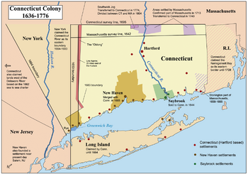
 Map of Connecticut annotated to show its colonial history and the establishment of its modern borders | |||||||
| الوضع | مستعمرة إنگليزية | ||||||
| العاصمة | سايبروك | ||||||
| اللغات المشتركة | الإنگليزية | ||||||
| الدين | Puritanism | ||||||
| الحكومة | Self-governing colony | ||||||
| Governor | |||||||
• 1635-1639 | John Winthrop the Younger | ||||||
• 1639-1644 | George Fenwick | ||||||
| التاريخ | |||||||
• تأسست | 1635 | ||||||
• اندمجت مع مستعمرة كنتبكت | 1644 | ||||||
| العملة | Pound sterling | ||||||
| |||||||
The Saybrook Colony was an English colony established in New England in late 1635 at the mouth of the Connecticut River which today is Old Saybrook, Connecticut. Saybrook was founded by John Winthrop the Younger, son of John Winthrop the Governor of the Massachusetts Bay Colony. Winthrop the Younger was designated Governor by the original settlers, including Colonel George Fenwick and Captain Lion Gardiner. They claimed possession of the land via a deed of conveyance from Robert Rich, 2nd Earl of Warwick. The colony was named in honor of Lords Saye and Brooke, prominent Parliamentarians and holders of the colony's land grants.
. . . . . . . . . . . . . . . . . . . . . . . . . . . . . . . . . . . . . . . . . . . . . . . . . . . . . . . . . . . . . . . . . . . . . . . . . . . . . . . . . . . . . . . . . . . . . . . . . . . . . . . . . . . . . . . . . . . . . . . . . . . . . . . . . . . . . . . . . . . . . . . . . . . . . . . . . . . . . . . . . . . . . . . .
التاريخ
Early settlers of the colony were ardent supporters of Oliver Cromwell and of democracy. Settlement preparations included sending a ship with an unusual cargo of ironwork for a portcullis and drawbridges, and even an experienced military engineer. Saybrook's fort was to be the strongest in New England. However, prominent Puritans soon "found the countrie [England] full of reports of their going", and they were worried that they would not be allowed to sell their estates and board their ship. By 1638, the plans for Saybrook were abandoned. The sponsors remained in England and played their respective political and military roles in the English Civil War and its aftermath. As a consequence, the colony struggled and, by 1644, the colony merged with the more vibrant Connecticut Colony a few miles up river.
In 1647, Major John Mason assumed command of Saybrook Fort, which controlled the main trade and supply route to the upper river valley. The fort mysteriously burned to the ground, but another improved fort was quickly built nearby. He spent the next 12 years there and served as Commissioner of the United Colonies, its chief military officer, Magistrate, and peacekeeper. He was continually called upon to fairly negotiate the purchase of Indian lands, write a treaty, or arbitrate some Indian quarrel, many of which were instigated by his friend Uncas.
See also
- Lower Connecticut River Valley – Connecticut planning region covering the area
References
- Young, Alfred A. (1991). "English Plebeian Culture and 18th Century American Radicalism". In Jacob, Margret C.; Jacob, James R. (eds.). The Origins of Anglo American Radicalism. New Jersey: Humanities Press International. p. 195. ISBN 978-1-57392-289-0. LCCN 90023163.
- Dunn, Richard S. (1962). Puritans and Yankees: The Winthrop Dynasty of New England. Princeton, NJ: Princeton University Press. ISBN 9780691045610. JSTOR j.ctt183q261. LCCN 62007400. Retrieved December 8, 2021.
Further reading
- Ward, Harry M. (1961). The United Colonies of New England: 1643–90. Vantage Press. LCCN 60015581.
- Andrews, Charles McLean (1934). The Colonial Period of American History – The Beginnings of Connecticut 1632–1662. Vol. II. Yale University Press.
External links
- Pages using gadget WikiMiniAtlas
- Short description is different from Wikidata
- Coordinates on Wikidata
- States and territories disestablished in 1644
- English colonization of the Americas
- Connecticut Colony
- Middlesex County, Connecticut
- History of the Thirteen Colonies
- Former English colonies
- States and territories established in 1635
- Colonial settlements in North America
- 1635 establishments in the Thirteen Colonies