مرداكرت (منطقة)
40°12′37″N 46°48′33″E / 40.21028°N 46.80917°E
مرداكرت
Մարտակերտ | |
|---|---|
 | |
| العاصمة | مرداكرت |
| الحكومة | |
| • الحاكم | Vladik Khachatryan |
| المساحة | |
| • الإجمالي | 1٬795 كم² (693 ميل²) |
| ترتيب المساحة | بالترتيب الرابع |
| التعداد (2013)[1] | |
| • الإجمالي | 20٬185 |
| • الترتيب | بالترتيب الثالث |
| • الكثافة | 11/km2 (29/sq mi) |
| الموقع الإلكتروني | Martakert Province |
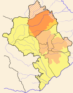
مرداكرت (بالأرمينية: Մարտակերտ؛ إنگليزية: Martakert) هي مقاطعة في جمهورية ناگورنو قرة باخ، كيان الأمر الواقع. الأراضي تتبع بقوة القانون أذربيجان. السكان معظمهم أرمن.
مقاطعة مرداكرت تتكون من 43 مجتمع، أحدهم يعتبر عمراني والـ 42 الباقون هم ريف.
المواقع الثقافية
The Gandzasar monastery, the Yeghishe Arakyal Monastery and the 17th century Armenian monastery Yerits Mankants are located in this province. The Vankasar Monastery is just outside the town of Martakert. The archaeological site of the town of Tigranakert is also located here. Thought to have been founded in the 2nd-1st century B.C, it has been undergoing excavation since 2005. Some of the walls of the city, with Hellenistic-style towers, as well as Armenian basilica dating to fifth to seventh centuries have been uncovered.
الهامش
انظر أيضاً
- Pages using gadget WikiMiniAtlas
- Coordinates on Wikidata
- Short description is different from Wikidata
- Pages using infobox settlement with missing country
- Pages using infobox settlement with no coordinates
- Articles containing أرمنية-language text
- Articles containing إنگليزية-language text
- Pages using Lang-xx templates
- مقاطعة مرداكرت


