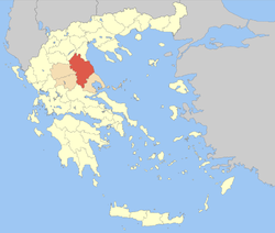
لاريسا (وحدة محلية)
Larissa
Περιφερειακή ενότητα Λάρισας | |
|---|---|
 | |
 Larissa within Greece | |
| الإحداثيات: 39°40′N 22°30′E / 39.667°N 22.500°E | |
| Country | Greece |
| Region | Thessaly |
| Capital | Larissa |
| المساحة | |
| • الإجمالي | 5٬381 كم² (2٬078 ميل²) |
| التعداد (2011) | |
| • الإجمالي | 284٬325 |
| • الكثافة | 53/km2 (140/sq mi) |
| منطقة التوقيت | UTC+2 |
| • الصيف (التوقيت الصيفي) | UTC+3 (EEST) |
| Postal codes | 40x xx, 41x xx |
| Area codes | 2410, 249x0 |
| ISO 3166 code | GR-42 |
| Car plates | ΡΙ |
لاريسا (باليونانية: Περιφερειακή ενότητα Λάρισας) هي إحدى مقاطعات اليونان.
. . . . . . . . . . . . . . . . . . . . . . . . . . . . . . . . . . . . . . . . . . . . . . . . . . . . . . . . . . . . . . . . . . . . . . . . . . . . . . . . . . . . . . . . . . . . . . . . . . . . . . . . . . . . . . . . . . . . . . . . . . . . . . . . . . . . . . . . . . . . . . . . . . . . . . . . . . . . . . . . . . . . . . . .
Administration
The regional unit Larissa is subdivided into 7 municipalities. These are (number as in the map in the infobox):[1]
Prefecture
Larissa was created as a prefecture (باليونانية: Νομός Λάρισας) in 1882. As a part of the 2011 Kallikratis government reform, the regional unit Larissa was created out of the former prefecture Larissa. The prefecture had the same territory as the present regional unit. At the same time, the municipalities were reorganised, according to the table below.[1]
| البلدية الجديدة | البلديات القديمة | المقر |
|---|---|---|
| Agia | Agia | Agia |
| Evrymenes | ||
| Lakereia | ||
| Melivoia | ||
| إلاسونا | إلاسونا | إلاسونا |
| Antichasia | ||
| Verdikoussa | ||
| Karya | ||
| Livadi | ||
| Olympos | ||
| Potamia | ||
| Sarantaporo | ||
| Tsaritsani | ||
| Farsala | Farsala | Farsala |
| Enippeas | ||
| Narthaki | ||
| Polydamantas | ||
| Kileler | Kileler | Nikaia |
| أرمينيو | ||
| كرانوناس | ||
| Nikaia | ||
| Platykampos | ||
| لاريسا (لاريسا) | لاريسا | لاريسا |
| Giannouli | ||
| Koilada | ||
| Tempi | Makrychori | Makrychori |
| Ampelakia | ||
| گونوي | ||
| Kato Olympos | ||
| Nessonas | ||
| تيرنافوس | تيرناڤوس | تيرنافوس |
| Ampelonas |
Historical Provinces
- Province of Larissa (Larissa)
- Province of Tyrnavos (Tyrnavos)
- Province of Agia (Agia)
- Province of Elassona (Elassona)
- Province of Farsala (Farsala)
Note: Provinces no longer hold any legal status in Greece, they were abolished in 2006.
التاريخ
الاقتصاد
Its main economy since the 1970s are manufacturing, businesses, communications and services. Agriculture is the second leading industry.
الزراعة
The Thessalian Plain is famous for its crops including fruits (watermelon and melon), vegetables (tomatoes, potatoes, cucumbers, onions, etc.), cotton, dairy, cattle and other crops.
الإعلام
التلفزيون
- TRT
- Thessaly
الصحف
- Agrotikoi Ekfasi - Larissa
- I Alitheia - Farsala
- Eleftheria - Larissa
- I Foni - Farsala
- Imerisios Kirykas - Larissa
- Ta Nea tis Farsalou - Farsala
النقل
There are a number of highways E75 and the main railway from Athens to Thessaloniki crosses Thessaly. The region is directly linked to the rest of Europe through International Airport of Central Greece located in Nea Anchialos in a small distance from Larisa (26 kilometers).
- Greek National Road 1/E75, SE, Cen., E - partially a divided superhighway
- Greek National Road 3, S, Cen., NW
- Central Greece Motorway - future
- Greek National Road 6, W, Cen., SE
- Greek National Road 13, NW
- Greek National Road 26, NW
- Greek National Road 30, S
- Larissa-Karditsa Road, S, SW
- Grevena-Elassona Road, NW
- Larissa-Melivoia Road, S, E
Sports
Sporting clubs include:
- Athletic Union of Larissa 1964
- Athlitiki Enosi Larissa F.C. - the only football team in Greece that ever won a championship other than the teams from Athens and Thessaloniki.
- Olympia Larissa BC
- AEL 1964 BC
انظر أيضاً
المراجع
- ^ أ ب "Kallikratis reform law text" (PDF).
