قمة بتة
| قمة بتة | |
|---|---|
| Bikku Bitti / Pic Bette | |
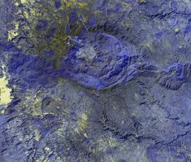
 تلوين مصطنع لقمة بتة (أسفل اليسار) | |
| أعلى نقطة | |
| الارتفاع | 2,266 m (7,434 ft) [1] |
| الإدراج | أعلى نقطة في البلد |
| الإحداثيات | 22°0′13″N 19°12′24″E / 22.00361°N 19.20667°E |
| الجغرافيا | |
| الموقع | ليبيا |
| السلسلة الأم | جبال تيبستي[1] |
قمة بتة Bikku Bitti، وتعرف أيضاً بإسم Bette Peak، هي أعلى جبل في ليبيا at 2,266 metres (7,434 ft).[2] وتقع في the Dohone spur في جبال تيبستي في جنوب ليبيا، بالقرب من الحدود التشادية.
Bikku Bitti is in one of the least known and least accessible parts of the Sahara Desert.[3] It was climbed in December 2005 by Ginge Fullen and his Chadian guides, who approached from the Chadian side. Although they were not the first to summit the mountain—Fullen reports that "there were a number of cairns on top we could clearly see"—it was the first documented climb.[3]
المراجع
- ^ أ ب "Pic Bette, Libya" on Peakbagger Archived 2011-08-07 at the Wayback Machine Retrieved 28 September 2011
- ^ "Bikku-bitti" on Peakery Archived 2012-03-31 at the Wayback Machine Retrieved 28 September 2011
- ^ أ ب First climb details on summitpost.org Archived 2013-05-25 at the Wayback Machine Retrieved 28 September 2011
