فيرث اوف فورث
| Firth of Forth | |
|---|---|
 Aerial view of the Forth bridges | |
| الموقع | Scotland, United Kingdom |
| الإحداثيات | 56°04′30″N 3°45′00″W / 56.075°N 3.750°W |
| بلدان الحوض | Scotland, United Kingdom |
| التوصيف | 30 October 2001 |
| الرقم المرجعي | 1111[1] |
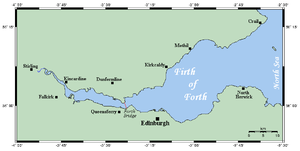
فيرث اوف فورث (غالية اسكتلندية: Linne Foirthe) iو [مصب []] أو الخور من اسكتلندا [[نهر] الرابع]، حيث ان تصب في بحر الشمال, بين فايف في الشمال ، و لوثيان الغربية, مدينة ادنبره في الجنوب، ووثيان الشرقية في الجنوب. التي كانت تعرف باسم Bodotria في العصر الروماني.
الجغرافيا والاقتصاد
جزر فيرث اوف فورث
- Bass Rock
- Craigleith
- Cramond
- Eyebroughy
- Fidra
- Inchcolm
- Inchgarvie
- Inchkeith
- Inchmickery with Cow and Calf
- The Lamb
- Isle of May
الاستيطان على الشريط الساحلي
- الساحل الشمالي
- الساحل الجنوبي
مناطق سياحية
- Aberlady Bay, Archerfield Links
- Barns Ness Lighthouse, Belhaven, Berwick Law, Blackness Castle
- Cockenzie Power Station, Culross
- Dalmeny House, Dirleton Castle
- Fa'side Castle
- Gullane Bents
- Hopetoun House, Hopetoun Monument
- John Muir Country Park, John Muir Way
- Longniddry Bents
- Musselburgh Racecourse
- North Berwick Golf Club
- Prestongrange Industrial Heritage Museum, Preston Tower
- Ravenscraig Castle
- Scottish Fisheries Museum, Scottish Seabird Centre
- Seton Sands
- St. Filan's Cave
- St. Monans Windmill
- Tantallon Castle, Torness Nuclear Power Station
- Waterston House
متفرقات

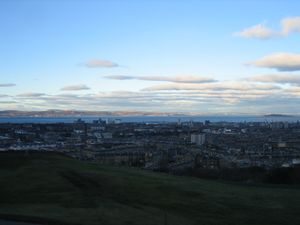
The Firth of Forth from Calton Hill

The Ro-Pax ferry Blue Star 1 passing under the Forth Bridge in the Firth, en route from Rosyth to Zeebrugge.
المصادر
- ^ "Firth of Forth". Ramsar Sites Information Service. Retrieved 25 أبريل 2018.
وصلات خارجية
- Isle of May bird observatory
- Forthfast experimental hovercraft service, 16-28 July 2007
- Inchcolm Virtual Tour Take a virtual tour around some of the Inchcolm's military defences
56°10′N 2°45′W / 56.167°N 2.750°W{{#coordinates:}}: لا يمكن أن يكون هناك أكثر من وسم أساسي واحد لكل صفحة
الكلمات الدالة:
This article contains content from Wikimedia licensed under CC BY-SA 4.0. Please comply with the license terms.
تصنيفات:
- Pages using gadget WikiMiniAtlas
- صفحات ذات وسوم إحداثيات غير صحيحة
- Short description is different from Wikidata
- Use dmy dates from May 2013
- Coordinates on Wikidata
- Articles containing غالية اسكتلندية-language text
- Pages using Lang-xx templates
- Articles with hatnote templates targeting a nonexistent page
- Firths of Scotland
- Ramsar sites in Scotland
- Sites of Special Scientific Interest in Dunfermline and Kirkcaldy
- Sites of Special Scientific Interest in Edinburgh and West Lothian
- Sites of Special Scientific Interest in Falkirk and Clackmannan
- Sites of Special Scientific Interest in Mid and East Lothian
- Sites of Special Scientific Interest in North East Fife
- بحر الشمال


