شمال حاپي

المصدر: "خريطة الاستكشاف - خريطة مصر". وزارة البترول المصرية.
شمال حاپي North Hap'y هو منطقة امتياز تنقيب في البحر المتوسط بالمنطقة الاقتصادية الخالصة المصرية.
المميزات والاحتياطيات
تتميز المنطقة بفرصة فريدة للتنقيب بالمياه العميقة (700-1200 م)، في منطقة دلتا النيل. أكثر من 30% من الأصول المشاركة في البلوك البحري البالغ مساحته مساحة 4.180 كم²، تقع بالقرب من الحقول المنتجة للغاز الطبيعي. [1]
ومن المحتمل أن تبلغ إحتياطيات النفط بالمنطقة عدة ترليونات مكعبة من الغاز أو بلايين البراميل من النفط.
تقدر مساحة بلوك 6 ب4.180 كم ويقع في الجزء الشمالي الشرقي من المياه العميقة للبحر المتوسط المواجهة لدلتا النيل. لم تتم بعد أي عمليات حفر في البلوك، غير أنه تم عمل عمليات مسح سيزمي على خط طوله 3.154 كم قام بها المشغلون السابقون وتم تحليلها.
تشير البيانات السيزمية لبلوك 6 إلى وجود طبقات سميكة من الرواسب الثلاثية والطباشيرية. Evidence of trap created by growth faults and by subsea channeling and mass-wasting is plentiful. تقع منطقة الإمتياز بالقرب من تمساح حاپي، الذي يعتقد أنها تضم حقول غاز عملاقة، على بعد حوالي 11 ميل جنوب بلوك 6. اكتشفت الحقول العملاقة في منطقة تمساح عام 1996 وتقدر احتياطياتيها 2 TCF من الغاز الطبيعي.
الامتياز والتطوير
رأس مال المرحلة الأولى يساوي 150 مليون دولار أمريكي.

طرحت الحكومة المصرية عطاء لمنطقة الامتياز عام 2006، وفاز الشركاء التاليون:
- شركة ولاية گجرات للنفط (50%)
- ألكور پترو المحدودة للبنية التحتيتة (20%)
- جيوگلوبال ريسورسز (30%)
GeoGlobal’s 30% participating interests in these 2 exploration blocks were recently assigned to GSPC in exchange for an option to re-acquire all or a portion of these rights on or before April 30, 2008. GeoGlobal would exercise this option to acquire all or a portion of these rights for an Interested Party.
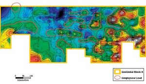
The Block 6 concession agreement with the Government of Egypt is being finalized and involves three exploration phases over a 10 year period. The four-year first phase commitment involves the acquisition of 2,500 square kilometers of 3D seismic data and the drilling of six exploratory wells with a minimum total cost of $150,000,000 (GGR 30% share = $45,000,000). The first well must be drilled within 2½ years of the concession agreement becoming finalized. The main target gas zones are clastic slope channel systems of Pliocene and Miocene Age. Deeper clastic oil play targets of Pliocene and Miocene Age. Deeper clastic oil play targets Geoglobal and its partners have performed preliminary interpretations of the 2D seismic database that covers the Block 6 Concession. As the map above indicates, structural closures are abundant throughout the concession. Some of the traps exceed 100 square kilometres in size and would require further investigation using 3D seismic before drilling.
The plat on the previous page and the two seismic sections shown above illustrate some of the potential of Block 6. The plat shows a multitude of structures at the M3 level with four-way closure. These same structures, shown on the seismic sections above, contain sands exhibiting bright amplitude anomalies. The strength of the amplitude anomalies indicate that the sands are fully gas charged. While all successful offshore Nile delta wells have encountered gas and gas liquids, there is reason to believe that oil is trapped in the deeper sediments. Because the source beds lie at the base of the succession, heavier hydrocarbons remain deeply buried while lighter hydrocarbons can migrate through semi-permeable rock to shallower depths.
Few wells have penetrated far into the Cretaceous strata in the offshore portion of the Nile delta. The greater value of an oil discovery would offset the higher costs of deep drilling.
الهامش
- ^ "GeoGlobal Resources Inc". hydrocarbonassets.com.


