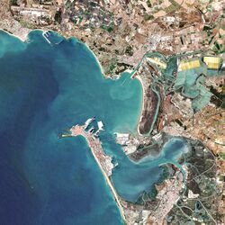
شرم قادس
شرم قادس
Bahía de Cádiz | |
|---|---|
 | |
| Country | إسبانيا |
| Region | Andalusia |
| المساحة | |
| • الإجمالي | 111 كم² (43 ميل²) |
| التصنيفات | |
|---|---|
| الاسم الرسمي | Bahía de Cádiz |
| التوصيف | 24 October 2002 |
| الرقم المرجعي | 1265[2] |
شرم قادس هو مسطح مائي في مقاطعة قادس، إسبانيا، بالقرب من الساحل الجنوبي الغربي لـ شبه الجزيرة الأيبيرية.
ينفتح شرم قادس على خليج قادس، المسطح المائي الأكبر الذي يتواجد في نفس المنطقة ولكن أبعد عن الساحل.
الجغرافيا
سواحل شرم قادس تضم بلديات قادس وSan Fernando, Puerto Real, El Puerto de Santa María, and Rota.[1]
The bay forms a natural harbour which according to available archaeological evidence has been inhabited since very ancient times.[3] The Bahía de Cádiz Natural Park is located on the shores of the Bay of Cádiz.
There is also a comarca with the name Bay of Cádiz.
انظر أيضاً
المراجع
- ^ أ ب Guia del patrimonio cultural del Parque Natural Bahia de Cádiz Archived ديسمبر 28, 2011 at the Wayback Machine
- ^ "Bahía de Cádiz". Ramsar Sites Information Service. Retrieved 25 April 2018.
- ^ El entorno de la Bahía de Cádiz a fines de la Edad del Bronce e inicios de la Edad del Hierro
وصلات خارجية
 Media related to Bay of Cádiz at Wikimedia Commons
- Puerto de la Bahía de Cádiz