پودگوشين
پودگوشين
Podgórzyn | |
|---|---|
قرية | |
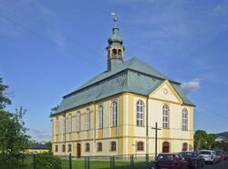
 Catholic Church of Our Lady of Częstochowa | |
| الإحداثيات: 50°49′57″N 15°41′1″E / 50.83250°N 15.68361°E | |
| البلد | |
| ڤويڤودية | سيليزيا السفلى |
| Powiat | يلنيا گورا |
| گمينا | Podgórzyn |
| أول ذِكر | 1318 |
| التعداد | |
| • الإجمالي | 1٬700 |
| منطقة التوقيت | UTC+1 (CET) |
| • الصيف (التوقيت الصيفي) | UTC+2 (CEST) |
| لوحة السيارة | DJE |
پودگوشين ( Podgórzyn؛ [pɔdˈɡuʐɨn] ؛ ألمانية: nieder-Giersdorf) هي قرية في مقاطعة يلنيا گورا، ڤويڤودية سيليزيا السفلى، في جنوب غرب پولندا.[1] It is the seat of the administrative district (gmina) called Gmina Podgórzyn.
It lies approximately 9 كيلومتر (6 mi) south-west of Jelenia Góra and 101 km (63 mi) west of the regional capital Wrocław.
التاريخ

The area became part of the emerging Polish state in the 10th century. Initially it was administratively part of the Wleń castellany.[2] The village was first mentioned in 1318, when it was part of fragmented Piast-ruled Poland.[3]
During World War II, in 1940–1942, the Germans used Belgian, French and Soviet prisoners of war and possibly also Czech and Polish civilians for forced labour to build a road connecting the village with Przełęcz Karkonoska, however, the construction was not completed.[4]
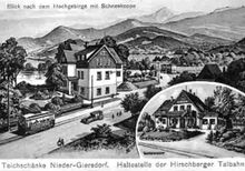
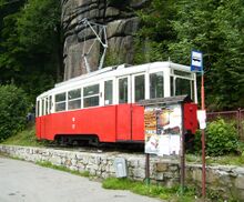
From 1911 to 1965, Podgórzyn was connected with Jelenia Góra by tram.[5]
المعالم
Cultural heritage sights of Podgórzyn include the Baroque Our Lady of Częstochowa church and Holy Trinity church.
المراجع
- ^ "Central Statistical Office (GUS) - TERYT (National Register of Territorial Land Apportionment Journal)" (in Polish). 2008-06-01.
{{cite web}}: CS1 maint: unrecognized language (link) - ^ Staffa, Marek (2001). Karkonosze (in البولندية). Wrocław: Wydawnictwo Dolnośląskie. p. 40. ISBN 83-7023-560-3.
- ^ Staffa, p. 56
- ^ Przerwa, Tomasz (2020). "Zatrudnienie jeńców belgijskich, francuskich i radzieckich przy budowie Drogi na Przełęcz Karkonoską (Spindlerpaßstraße) 1940–1942". Łambinowicki rocznik muzealny (in البولندية). Opole. 43: 5, 8–9, 16. ISSN 0137-5199.
- ^ Staffa, p. 221
وصلات خارجية
- Pages using gadget WikiMiniAtlas
- CS1 البولندية-language sources (pl)
- Short description is different from Wikidata
- Coordinates on Wikidata
- Pages using infobox settlement with unknown parameters
- Articles containing ألمانية-language text
- Pages using Lang-xx templates
- Populated riverside places in Poland
- Villages in Karkonosze County


