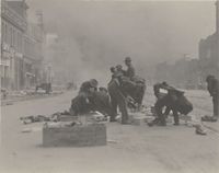
زلزال سان فرانسيسكو 1906

| |
| التاريخ | 18 أبريل 1906 |
|---|---|
| المقدار | 7.9 Mw[1] |
| العمق | 8 kilometers (5.0 mi)[2] |
| موقع مركز الزلزال | 37°45′N 122°33′W / 37.75°N 122.55°W[2] |
| البلدان/ المناطق المتأثرة |
United States (San Francisco Bay Area) |
| الضحايا | |

زلزال سان فرانسيسكو عام 1906 من الزلازل الكبرى التي ضربت سان فرانسيسكو كاليفورنيا والسواحل الشمالية لكاليفورنيا في 5:12 يوم الأربعاء 18 أبريل، 1906.[3] التقدير الأكثر قبولا على نطاق واسع لحجم الزلزال هو مقياس العزم الزلزالي (Mw) of 7.9;[1] ومع ذلك ، فإن قيما أخرى قد أقترحت من 7،7 إلى 8،25 على المقياس.[4] الصدمة الرئيسية مركز الزلزال وقعت خارج الشاطىء حوالي 2 كيلومتر (3 كم) من المدينة ، قرب موصيل روك. تمزقت على صدع سان أندرياس شمالا وجنوبا على حد سواء على طول مجموعه296 ميل (477 كم).[5]وساد شعور بالإرتجاجات من ولاية اوريگون الى لوس أنجيلس كاليفورنيا، وداخل اليابسة كما تبعد عن مركز نيڤادا .[6] وتعد الزلزال والحرائق الناتجة باعتبارها واحدة من أسوأ الكوارث الطبيعية في تاريخ الولايات المتحدة[7] وجنبا إلى جنب مع إعصار جالفستون 1900. فإن عدد القتلى من جراء الزلزال والحرائق الناتجة عن ذلك ، يقدر ان يكون فوق 3000، [8] هو أعظم خسارة في الأرواح من جراء وقوع كارثة طبيعية في تاريخ كاليفورنيا. وقد تم مقارنتها مع تأثير الإعصار الأخير و اقتصاد كاترينا.[9]
. . . . . . . . . . . . . . . . . . . . . . . . . . . . . . . . . . . . . . . . . . . . . . . . . . . . . . . . . . . . . . . . . . . . . . . . . . . . . . . . . . . . . . . . . . . . . . . . . . . . . . . . . . . . . . . . . . . . . . . . . . . . . . . . . . . . . . . . . . . . . . . . . . . . . . . . . . . . . . . . . . . . . . . .
الآثار
في ذلك الوقت ، أبلغ عن 375 حالة وفاة;[10] the figure was fabricated by government officials who felt that reporting the true death toll would hurt real estate prices and efforts to rebuild the city; additionally, hundreds of casualties in Chinatown went ignored and unrecorded. This figure is still uncertain today, estimated to roughly 3,000 at minimum.[11] Most of the deaths occurred in San Francisco itself, but 189 were reported elsewhere in the Bay Area;[3] nearby cities, such as Santa Rosa and [[San Jose, California|Sanp;l[p l also suffered severe damages. In Monterey County, the earthquake permanently shifted the course of the Salinas River near its mouth. Where previously the river emptied into Monterey Bay between Moss Landing and Watsonville, it was diverted 6 miles south to a new outlet just north of Marina.
الجيولوجيا

الحرائق التالية
دور الجيش بعد الزلزال
الذكرى المئوية

التحليل

انظر أيضاً
- 1989 Loma Prieta earthquake
- Andrew Lawson, editor of the 1908 report on the earthquake
- Arnold Genthe and George R. Lawrence, photographers of the earthquake
- Committee of Fifty (1906)
- Earthquake engineering
- Earthquakes in California
- List of earthquakes in the United States
الهامش
- ^ أ ب Where can I learn more about the 1906 Earthquake? , مختبر بيركلي رصد الزلازل.
- ^ أ ب Location of the Focal Region and Hypocenter of the California Earthquake of April 18, 1906
- ^ أ ب USGS – The Great 1906 San Francisco Earthquake
- ^ 1906 Earthquake: What was the magnitude? الوصول إلى شمال كاليفورنيا، 19 سبتمبر 2006 -- دائرة المسح الجيولوجي الأميركية برنامج مخاطر الزلازل
- ^ 1906 Earthquake: How long was the 1906 Crack? USGS Earthquake Hazards Program – Northern California, Accessed September 3, 2006
- ^ Christine Gibson "Our 10 Greatest Natural Disasters," American Heritage, Aug./Sept. 2006.
- ^ John Dvorak "San Francisco Then and Now," American Heritage, April/May 2006.
- ^ Timeline of the San Francisco Earthquake April 18 – 23, 1906 ,المتحف الافتراضي لمدينة سان فرانسيسكو
- ^ جون كيلباتريك و صوفيا ديرميسي، في أعقاب الإعصار: توصيات للبحوث العقارية, مجلة الأدب العقارى, ربيع عام, 2007
- ^ وليام برونسون، اهتزت الارض، واحترقت السماء(San Francisco: Chronicle Books, 1996)
- ^ Casualties and Damage after the 1906 earthquake USGS Earthquake Hazards Program – Northern California, Accessed September 4, 2006
- ^ Library of Congress P&P Online Catalog – Panoramic Photographs (http://lcweb2.loc.gov/pp/panabt.html)


