رصيف لارسن الجليدي

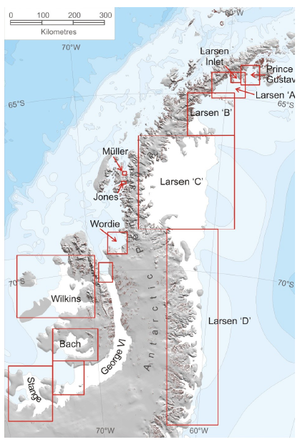
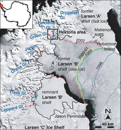
رصيف لارسن الجليدي Larsen Ice Shelf هو رصيف جليدي طويل في الجزء الشمالي الغربي من بحر ودل، ويمتد بطول الساحل الشرقي لـشبه جزيرة أنتارتيكا من رأس لونگنگ إلى المنطقة إلى الجنوب مباشرة من جزيرة هيرست. وهو مسمى على اسم الكاپتن كارل أنطون لارسن، سيد سفينة صيد الحيتان النرويجية Jason, who sailed along the ice front as far as 68°10' South during December 1893.[1] In finer detail, the Larsen Ice Shelf is a series of shelves that occupy (or occupied) distinct embayments along the coast. From north to south, the segments are called Larsen A (the smallest), Larsen B, and Larsen C (the largest) by researchers who work in the area.[2] Further south, Larsen D and the much smaller Larsen E, F and G are also named.[3][4]
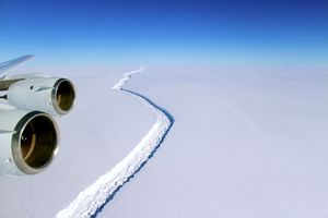
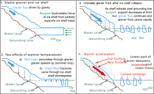
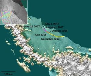
The breakup of the ice shelf since the mid-1990s has been widely reported,[5] with the collapse of Larsen B in 2002 being particularly dramatic. A large section of the Larsen C shelf was reported to have broken away in the week beginning 10 July 2017.[6]
. . . . . . . . . . . . . . . . . . . . . . . . . . . . . . . . . . . . . . . . . . . . . . . . . . . . . . . . . . . . . . . . . . . . . . . . . . . . . . . . . . . . . . . . . . . . . . . . . . . . . . . . . . . . . . . . . . . . . . . . . . . . . . . . . . . . . . . . . . . . . . . . . . . . . . . . . . . . . . . . . . . . . . . .
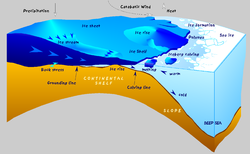
الرصيف الجليدي
الانفصال
لارسن A
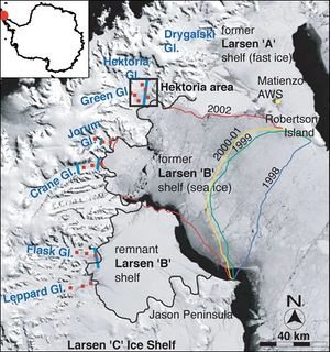
The Larsen A ice shelf disintegrated in January 1995.[2]
لارسن B
From 31 January 2002 to March 2002 the Larsen B sector partially collapsed and parts broke up, 3,250 km2 (1,250 sq mi) of ice 220 m (720 ft) thick, an area comparable to the US state of Rhode Island.[7] In 2015, a study concluded that the remaining Larsen B ice-shelf will disintegrate by 2020, based on observations of faster flow and rapid thinning of glaciers in the area.[8]
لارسن C
اعتبارا من July 2017[تحديث], Larsen C is the fourth largest ice shelf in Antarctica, with an area of about 44,200 km2 (17,100 sq mi).[9]
لارسن D
The Larsen D Ice Shelf is located between Smith Peninsula in the south and Gipps Ice Rise in the north. It is considered to be generally stable. Over roughly the past fifty years it has advanced where the other ice shelves George VI, Bach, Stange, and Larsen C have all retreated. However, this gain has been relatively small in comparison to the retreat of the others. The most recent survey of Larsen D measured it at 22,600 square kilometres. There is fast ice along the entire front. This makes it difficult to interpret the ice front because the semi-permanent sea ice varies in thickness and may be nearly indistinguishable from shelf ice.[10]
معرض صور
Clear view of the Antarctic Peninsula, the Larsen Ice Shelf, and the sea ice covered waters around the region.
انظر أيضاً
الهامش
- ^ U.S. Geological Survey Geographic Names Information System: رصيف لارسن الجليدي
- ^ أ ب Fox, Douglas. "Witness to an Antarctic Meltdown". 307 (1): 54–61. doi:10.1038/scientificamerican0712-54.
{{cite journal}}: Cite journal requires|journal=(help) - ^ Rignot, E; Jacobs, S; Mouginot, J; Scheuchl, B (13 June 2013). "Ice Shelf Melting Around Antarctica" (PDF). Science. 341 (6143): 266–270. doi:10.1126/science.1235798. Retrieved 21 January 2017.
- ^ ice Break in Antartica
- ^ Chris Wickham (9 May 2012). "Warm water threatens vast Antarctic ice shelf (+video)". The Christian Science Monitor / Reuters. Retrieved 20 January 2017.
- ^ "Iceberg four times the size of London breaks off from Antarctica ice shelf". The Daily Telegraph. 12 July 2017.
- ^ Hulbe, Christina (2002). "Larsen Ice Shelf 2002, warmest summer on record leads to disintegration". Portland State University.
- ^ "NASA Study Shows Antarctica's Larsen B Ice Shelf Nearing Its Final Act" (Press release). NASA. 14 May 2015.
- ^ "Growing Crack in Antarctica's Larsen C Ice Shelf Spotted by NASA's MISR".
- ^ Overview of areal changes of the ice shelves on the Antarctic Peninsula over the past 50 years. The Cryosphere Discussions. 3 pp579-630. URL: http://www.the-cryosphere-discuss.net/3/579/2009/tcd-3-579-2009.pdf
وصلات خارجية
- "Break up of the Larsen Ice Shelf, Antarctica", NASA Earth Observatory.
- Coastal-change and Glaciological Map of the Larsen Ice Shelf Area, Antarctica, 1940-2005 United States Geological Survey
- Antarctic ice rift close to calving, after growing 17km in 6 days (Swansea University, Project Midas - June 2017)
خطأ لوا في وحدة:Authority_control على السطر 278: attempt to call field '_showMessage' (a nil value). 67°30′S 62°30′W / 67.500°S 62.500°W
- Pages using gadget WikiMiniAtlas
- مقالات فيها عبارات متقادمة منذ July 2017
- جميع المقالات التي فيها عبارات متقادمة
- Pages with empty portal template
- Coordinates on Wikidata
- Argentine Antarctica
- British Antarctic Territory
- Chilean Antarctic Territory
- Geography of the British Antarctic Territory
- Ice shelves of Antarctica
- Landforms of the Antarctic Peninsula
