رادڤان ناد دونايوم
Radvaň nad Dunajom
Dunaradvány | |
|---|---|
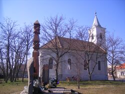
 Reformated church | |
Location of Pribeta in the Nitra Region Location of Pribeta in Slovakia | |
| الإحداثيات: 47°45′N 18°22′E / 47.75°N 18.37°E | |
| Country | |
| Region | قالب:Country data Nitra Region |
| District | Komárno District |
| First mentioned | 1260 |
| المساحة | |
| • الإجمالي | 15٫76 كم² (6٫08 ميل²) |
| المنسوب | 111 m (364 ft) |
| التعداد (2021)[3] | |
| • الإجمالي | 708 |
| منطقة التوقيت | UTC+1 (CET) |
| • الصيف (التوقيت الصيفي) | UTC+2 (CEST) |
| Postal code | 946 38[2] |
| مفتاح الهاتف | +421 35[2] |
| Car plate | KN |
| الموقع الإلكتروني | www |
Radvaň nad Dunajom (مجرية: Dunaradvány, تـُنطق [ˈdunɒrɒdvaːɲ]) is a municipality at the Danube in the Komárno District of the Nitra Region in Slovakia.
. . . . . . . . . . . . . . . . . . . . . . . . . . . . . . . . . . . . . . . . . . . . . . . . . . . . . . . . . . . . . . . . . . . . . . . . . . . . . . . . . . . . . . . . . . . . . . . . . . . . . . . . . . . . . . . . . . . . . . . . . . . . . . . . . . . . . . . . . . . . . . . . . . . . . . . . . . . . . . . . . . . . . . . .
Etymology
The name is derived from the Slavic personal name Radovan.[4]
History
In the 9th century, the territory of Radvaň nad Dunajom became part of the Kingdom of Hungary. It was first mentioned as a village in 1260. The 1606 Peace of Zsitvatorok was signed in Žitavská Tôň, a small settlement near or identical with Žitava, which is now part of Radvaň nad Dunajom. After the Austro-Hungarian army disintegrated in November 1918, Czechoslovak troops occupied the area, later acknowledged internationally by the Treaty of Trianon. Between 1938 and 1945 Radvaň nad Dunajom once more became part of Miklós Horthy's Hungary through the First Vienna Award. From 1945 until the Velvet Divorce, it was part of Czechoslovakia. Since then it has been part of Slovakia.
السكان
According to the census of 2001, the municipality has 91.46% Hungarian majority and 7.99% Slovak minority.[5]
المراجع
- ^ "Hustota obyvateľstva - obce [om7014rr_ukaz: Rozloha (Štvorcový meter)]". www.statistics.sk (in السلوفاكية). Statistical Office of the Slovak Republic. 2022-03-31. Retrieved 2022-03-31.
- ^ أ ب ت "Základná charakteristika". www.statistics.sk (in السلوفاكية). Statistical Office of the Slovak Republic. 2015-04-17. Retrieved 2022-03-31.
- ^ "Počet obyvateľov podľa pohlavia - obce (ročne)". www.statistics.sk (in السلوفاكية). Statistical Office of the Slovak Republic. 2022-03-31. Retrieved 2022-03-31.
- ^ Hladký, Juraj (2013). "Vlastné meno onymickom v regionálnom systéme" (PDF). Актуальні проблеми філології та перекладознавства (in Slovak): 283. ISSN 2415-7929.
{{cite journal}}: CS1 maint: unrecognized language (link) - ^ Statistics.sk[dead link]
- Pages using gadget WikiMiniAtlas
- CS1 السلوفاكية-language sources (sk)
- Articles with dead external links from December 2017
- Short description is different from Wikidata
- Coordinates on Wikidata
- Articles containing مجرية-language text
- Pages using Lang-xx templates
- Villages and municipalities in the Komárno District
- Populated places on the Danube
- Municipalities in Slovakia where Hungarian is an official language


