خليج ساراسوتا
| Sarasota Bay | |
|---|---|
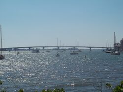
 John Ringling Causeway to St. Armand Circle, across Sarasota Bay | |
| الموقع | |
| Country | United States |
| State | Florida |
| Counties | Sarasota, Manatee |
| سمات الحوض | |
| Protection status | |
 | |
Sarasota Bay is a lagoon located off the central west coast of Florida in the United States. Though no significant single stream of freshwater enters the bay, with a drainage basin limited to 150 square miles in Manatee and Sarasota counties,[1] it is generally treated as an estuary, with three "passes" or inlets giving access from the Gulf of Mexico. Its source of freshwater has been increased from natural historical levels by urban runoff.[2]

The bay and its surrounding area appeared on the earliest maps of the area, being named Zarazote on one dating from the early 18th century. Hunting in the area had supported native populations for more than ten thousand years as Florida attracted some of the earliest human settlements in the hemisphere. Following the retreat of the glaciers, ocean levels rose creating the current coastline and the natural bounty of Sarasota Bay provided food for inhabitants for over five thousand years before Europeans began exploration of the area in 1513 and later, establishing settlements along its shores.
Sarasota Bay, the largest and deepest coastal bay between Tampa Bay and Charlotte Harbor, is one of twenty-eight estuaries in the country that have been named by the U.S. Congress as an estuary of national significance. The bay lies between barrier islands called keys, that separate the body of water from the Gulf of Mexico and the Florida mainland. Longboat Key, Lido Key, Siesta Key, and Casey Key are the major keys that delineate the main bay and its smaller portions.
. . . . . . . . . . . . . . . . . . . . . . . . . . . . . . . . . . . . . . . . . . . . . . . . . . . . . . . . . . . . . . . . . . . . . . . . . . . . . . . . . . . . . . . . . . . . . . . . . . . . . . . . . . . . . . . . . . . . . . . . . . . . . . . . . . . . . . . . . . . . . . . . . . . . . . . . . . . . . . . . . . . . . . . .
Ecotourism

Ecotourism based on kayak trips is gaining in popularity in Sarasota Bay. Guided kayak trips take kayakers on a tour of the local ecosystem. Kayakers can watch dolphins breach and manatees eat sea grass, in shallow bay water.[3]
References
- ^ National Estuary Program Coastal Condition Report: Sarasota Bay.
- ^ Noted in National Estuary Program Coastal Condition Report.
- ^ "Kayak Coasting, SRQ Magazine(2015)". Retrieved 2017-04-02.
External links
- Sarasota Bay page, Sarasota Water Atlas
- Oral History Slideshow: Dr. Ernest Estevez and the Creation of the Sarasota Bay National Estuary Program
- U.S. Coast & Geodetic Survey Map of Sarasota Bay, 1883
خطأ لوا في وحدة:Authority_control على السطر 278: attempt to call field '_showMessage' (a nil value).
- Pages using gadget WikiMiniAtlas
- Short description is different from Wikidata
- Infobox mapframe without OSM relation ID on Wikidata
- Coordinates on Wikidata
- Bays of Florida on the Gulf of Mexico
- Bodies of water of Manatee County, Florida
- Bodies of water of Sarasota County, Florida
- Sarasota, Florida
- Outstanding Florida Waters
- صفحات مع الخرائط
