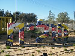
حوليت
Holit
חוֹלִית حوليت | |
|---|---|
 | |
| الإحداثيات: 31°13′48″N 34°19′36″E / 31.23000°N 34.32667°E | |
| District | Southern |
| المجلس | Eshkol |
| الانتماء | Kibbutz Movement |
| Founded | 1978 (in Sinai) 1982 (current location) |
| أسسها | Nahal |
| التعداد (2019)[1] | 169 |
حوليت (بالعبرية: חוֹלִית، وتعني: كثب ؛ Holit) is a kibbutz in the Hevel Shalom region of south-west Israel. Located near Nir Yitzhak, the kibbutz is under the jurisdiction of Eshkol Regional Council. In 2019 it had a population of 169.[1]
. . . . . . . . . . . . . . . . . . . . . . . . . . . . . . . . . . . . . . . . . . . . . . . . . . . . . . . . . . . . . . . . . . . . . . . . . . . . . . . . . . . . . . . . . . . . . . . . . . . . . . . . . . . . . . . . . . . . . . . . . . . . . . . . . . . . . . . . . . . . . . . . . . . . . . . . . . . . . . . . . . . . . . . .
التاريخ
The kibbutz was established in 1978 as a Nahal settlement near Yamit, in the Sinai Peninsula. However, as a result of the Israel-Egypt Peace Treaty in 1979, Israel was required to evacuate all its settlements in the peninsula.
In 1982 the kibbutz was re-established in its current location.
الانتاج
Holit has three main types of income the cow ranch, factory and fields. The factory produces juicers, about 50 a week. Oranges, lemons, potatoes, mangos, nuts and carrots are all grown in the fields.
المراجع
- ^ أ ب "Population in the Localities 2019" (XLS). Israel Central Bureau of Statistics. Retrieved 16 August 2020.
وصلات خارجية
- Holit Negev Information Centre
- Pages using gadget WikiMiniAtlas
- Short description is different from Wikidata
- Articles containing explicitly cited عربية-language text
- Coordinates on Wikidata
- Pages using infobox settlement with missing country
- Articles containing عبرية-language text
- مجلس إشكول الإقليمي
- كيبوتسيم
- حركة الكيبوتسات
- Populated places established in 1978
- Populated places established in 1982
- Nahal settlements
- مستوطنات إسرائيلية سابقة في سيناء
- غلاف غزة
- أماكن مأهولة في المنطقة الجنوبية (إسرائيل)
- 1978 establishments in the Israeli Military Governorate
- 1982 disestablishments in the Israeli Military Governorate
- 1982 establishments in Israel
