حت نب
بيت الذهب | ||||
| ḥ(w)t nb[1] بالهيروغليفية |
|---|
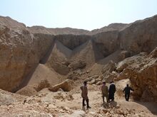
حت نب Hatnub كانت موقع محاجر ألباستر مصري ومستوطنة عمال موسمية مقترنة بالمحجر في الصحراء الشرقية، على بعد 65 كم من المنيا، جنوب شرق العمارنة. The pottery, hieroglyph inscriptions and hieratic graffiti at the site show that it was in use intermittently from at least as early as the reign of Khufu until the Roman period (c. 2589 BC–AD 300). The Hatnub quarry settlement, associated with three principal quarries, like those associated with gold mines في وادي الحمامات and elsewhere, are characterized by drystone windbreaks, roads, causeways, cairns and stone alignments.
Hatnub was first described in modern times by Percy Newberry and Howard Carter in 1891. There are many inscriptions on the rocks, and these were first described by George Willoughby Fraser and Marcus Worsley Blackden, members of this same expedition. For nearly hundred years, archaeologists concentrated on finding and translating these inscriptions which illuminated much ordinary life in ancient Egypt. Only when Ian Shaw and his team began studying the material remains were the two integrated to give a fuller picture.
فعلى سبيل المثال، لم يُعثر على أي نقوش من المملكة الحديثة، وقد اِعتُقِد أن المحاجر لم تُستخدم أثناء تلك الفترة. شو وفريقه عثروا على شظايا خزف من الدولة الحديثة تبين أن عمالاً من تلك الفترة حتماً قد استخدموا هذا المحجر.
منحدر
In 2018, researchers from the University of Liverpool's Department of Archaeology, Classics and Egyptology (ACE) and the Institut Français d'Archéologie Orientale (IFAO) announced the discovery of an ancient ramp at the site. The well-preserved ramp, which dates to the reign of Khufu, may shed light on how his Great Pyramid was constructed.[2][3]
Project co-director Yannis Gourdon from the IFAO says that "the system is composed of a central ramp flanked by two staircases with numerous post holes. Using a sled which carried a stone block and was attached with ropes to these wooden posts, ancient Egyptians were able to pull up the alabaster blocks out of the quarry on very steep slopes of 20 percent or more."[2]
ببليوگرافيا
- R. Anthes, (1928) Die Felseninschriften von Hatnub", (UGAA 9) (Leipzig).
- G.W. Fraser, (1894), 'Hat-Nub', PSBA16: 73-82.
- T.G.H. James, (1991), 'The discovery and identification of the Alabaster Quarries of Hatnub' in Melanges Jacques Jean Clere CRIPEL 13.
- I. Shaw, (1986), 'A survey at Hatnub', Amarna reports III, ed. B.J. Kemp (London), 189-212.
- I. Shaw, (2010), Hatnub: Quarrying Travertine in Ancient Egypt, EES Excavation Memoir 88, (London)
- The Dictionary of Ancient Egypt, pg. 119-20
المراجع
- ^ Gauthier, Henri (1927). Dictionnaire des Noms Géographiques Contenus dans les Textes Hiéroglyphiques Vol. 4. p. 79.
- ^ أ ب "Ancient quarry ramp system may have helped workers build Egypt's Great Pyramids".
- ^ "This 4,500-Year-Old Ramp Contraption May Have Been Used to Build Egypt's Great Pyramid". Live Science. 31 October 2018.
