جزر مهب الريح (جزر الجمعية)
Native name: Îles du Vent | |
|---|---|
 | |
 | |
| الجغرافيا | |
| الموقع | Pacific Ocean |
| الإحداثيات | 17°32′S 149°50′W / 17.533°S 149.833°W |
| الأرخبيل | Society Islands |
| الجزر الرئيسية | Tahiti, Moorea, Mehetia, Tetiaroa |
| المساحة | 1,195 km2 (461 sq mi) |
| أعلى منسوب | 2٬241 m (7٬352 ft) |
| أعلى نقطة | Mont Orohena |
| الإدارة | |
فرنسا | |
| Overseas collectivity | French Polynesia |
| Largest settlement | Papeete (capital) (pop. 131,695 urban) |
| السكان | |
| التعداد | 194,623[1] (Aug. 2007 census) |
| الكثافة السكانية | 163 /km2 (422 /sq mi) |
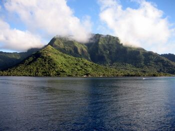
The Windward Islands (فرنسية: Îles du Vent) are the eastern group of the Society Islands in French Polynesia, an overseas collectivity of France in the southern Pacific Ocean. These islands were also previously named the Georgian Islands in honour of King George III of the United Kingdom.
. . . . . . . . . . . . . . . . . . . . . . . . . . . . . . . . . . . . . . . . . . . . . . . . . . . . . . . . . . . . . . . . . . . . . . . . . . . . . . . . . . . . . . . . . . . . . . . . . . . . . . . . . . . . . . . . . . . . . . . . . . . . . . . . . . . . . . . . . . . . . . . . . . . . . . . . . . . . . . . . . . . . . . . .
الجغرافيا
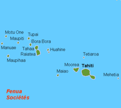
The archipelago comprises an administrative division (فرنسية: subdivision administrative) of French Polynesia, and includes the following islands:
The capital of the administrative district is Papeete on the island of Tahiti. Tahiti, Moorea, and Mehetia are high islands. Tetiaroa and Maiao are coral atolls.
الثقافة
The majority of the population speaks French and Tahitian (co-official with French throughout French Polynesia).
الادارة
The Windward Islands form the administrative subdivision of the Windward Islands (subdivision administrative des Îles du Vent), one of French Polynesia's five administrative subdivisions. The administrative subdivision of the Windward Islands geographically co-extensive with the electoral district of the Windward Islands (circonscription des Îles du Vent), one of French Polynesia's 6 electoral districts (circonscriptions électorales) for the Assembly of French Polynesia (see also Politics of French Polynesia).
الهامش
- ^ Institut Statistique de Polynésie Française (ISPF). "Recensement de la population 2007" (PDF) (in الفرنسية). Archived from the original (PDF) on 2007-12-03. Retrieved 2007-12-02.