جبل فارو
| Gibralfaro | |
|---|---|
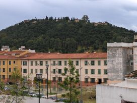
 Mount Gibralfaro with the Castle on top | |
| أعلى نقطة | |
| الارتفاع | 130 m (430 ft) |
| الإحداثيات | 36°43′24″N 04°24′39″W / 36.72333°N 4.41083°W |
| الجغرافيا | |
| السلسلة الأم | Montes de Málaga |
| الجيولوجيا | |
| نوع الجبل | Limestone |
| التسلق | |
| أسهل السبل | From Málaga |
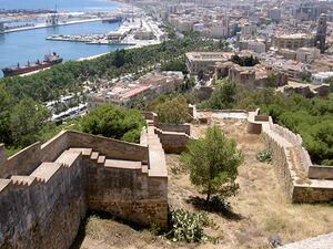
جبل فارو Gibralfaro، يقع في مالقة شمال شرق إسپانيا، وهو تل بارتفاع 130 متر فوق سطح البحر وكان موقع للحصون أثناء تأسيس المدينة في العهد الفينيقي. في بداية القرن 14، أمر يوسف الأول من مملكة غرناطة بإنشاء قلعة على قمة الجبل على الطراز الفينيقي. اشتق اسم الجبل من الكلمة الفينيقية فارو وتعني الضوء، ويعني جبل فارو "جبل الضوء". وتشرف قلعة فارو على مدينة مالقة المعاصرة وعلى البحر المتوسط.
التاريخ
Gibralfaro has been the site of fortifications since the Phoenician foundation of Málaga city, circa 770 BC.[بحاجة لمصدر] The location was fortified by Caliph Abd-al-Rahman III in 929 CE. At the beginning of the 14th century, Yusuf I of the Kingdom of Granada expanded the fortifications within the Phoenician lighthouse enclosure and erected a double wall to the Alcazaba. The name is said to be derived from Arabic, Jabal (عربية: جَبَل) the word for mountain, and Greek the word for light, meaning "rock of the lighthouse".[1] In Arabic it is called Jabal Fārū (عربية: جبل فارو) or Jabal Al-Fārū (عربية: جبل الفارو). The castle is famous for its three-month siege in 1487 by the Catholic monarchs, King Ferdinand and Queen Isabella, which ended when hunger forced the Arabs to surrender.

The most visible remains of the Castle today are the solid ramparts rising above the pines In the Centro de Interpretación de Gibralfaro (Gibralfaro Interpretation Center) in the former gunpowder arsenal of the Castle is a little museum that shows the castle’s history over the centuries since the Reconquest. The castle was used as a military base until 1925.[بحاجة لمصدر]
At the end of 2005, a thick forest of pines and eucalyptus trees were planted on the hill. On its outskirts are the historical buildings of the seminary and the Alcazaba, the Jardines de Puerta Oscura (Dark Gate Gardens), as well as a Parador.[2]
Currently pending approval is a project intended to safeguard the mount and its surroundings from any urban intervention and promote it as a space for public recreation. Another project is planned to build a cable car linking the city center with the Gibralfaro castle.[3]
الجيولوجيا
Gibralfaro is part of the southern foothills of the Montes de Málaga, a mountain range of the Cordillera Penibética, formed of materials from the Maláguide complex of the Baetic Cordillera.
المراجع
- ^ "Gibralfaro Castle, Malaga". Andalucia.com (in الإنجليزية). 2011-11-25. Retrieved 2022-07-15.
- ^ Conocer España por la ruta de los paradores, Ediciones Gaesa, page 90
- ^ Impulso al plan para proteger el Monte Gibralfaro y potenciar su uso cultural - Málaga Hoy
- This article incorporates information from the equivalent article on the Spanish Wikipedia
هوامش
المصادر
- ويكيپيديا الإسپانية
- Pages using gadget WikiMiniAtlas
- Short description is different from Wikidata
- Coordinates on Wikidata
- Wikidata value to be checked for Infobox mountain
- Articles with unsourced statements from July 2022
- Articles containing explicitly cited عربية-language text
- Penibaetic System
- Landforms of Andalusia
- Hills of Spain
- مباني ومنشآت في مالقة
- مباني ومنشآت اكتملت في القرن 14


