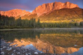
جبل جون لوري
| جبل جون لوري | |
|---|---|
| إيامانثكا، جبل يامنوسكا | |
 يامنوسكا | |
| أعلى نقطة | |
| الارتفاع | 2,240 m (7,350 ft) [1] |
| الإدراج | جبال ألبرتا |
| الإحداثيات | 51°07′27″N 115°07′06″W / 51.12417°N 115.11833°W [2] |
| الجغرافيا | |
Municipal District of Bighorn No. 8، ألبرتا، كندا | |
| السلسلة الأم | الصخور الكندية |
| الخريطة الطبوغرافية | NTS قالب:Canada NTS Map Sheet |
| الجيولوجيا | |
| عمر الصخر | Paleozoic |
| نوع الجبل | حجر جيري وطفل صفحي |
| التسلق | |
| أول صعود | Unknown |
| أسهل السبل | Scramble[1] |
جبل جون لوري (Mount John Laurie)، هو جبل يقع في ألبرتا، كندا. وهو جزء من الصخور الكندية، وجهة شهيرة لهواة تسلق الصخور.
. . . . . . . . . . . . . . . . . . . . . . . . . . . . . . . . . . . . . . . . . . . . . . . . . . . . . . . . . . . . . . . . . . . . . . . . . . . . . . . . . . . . . . . . . . . . . . . . . . . . . . . . . . . . . . . . . . . . . . . . . . . . . . . . . . . . . . . . . . . . . . . . . . . . . . . . . . . . . . . . . . . . . . . .
الأسماء
Officially named Mount John Laurie in 1961,[3] it is also known as Mount Laurie, or by its original Stoney Nakoda name Îyâmnathka, borrowed into English as Mount Yamnuska or simply Yamnuska.[3] Îyâmnathka is a compound that includes root words meaning "mountain" and "flat",[4] however it is usually translated more figuratively as "flat-faced mountain".[5]
John Lee Laurie, 1899–1959, was a founder of the Indian Association of Alberta. The mountain's 1961 renaming came at the request of the Stoney Nakoda First Nation. Laurie, an educator and political activist, served as secretary of the Indian Association of Alberta from 1944 to 1956, promoting the causes of First Nations in Alberta.[6]
القمة والتسلق
Standing at approximately 2,240 m (7,350 ft) above sea level,[7] Mount John Laurie is the last mountain on the north side of the Bow River valley (Bow Valley) as it exits the mountains for the foothills and prairie of Alberta. Located close to Calgary, it is a popular "great scramble". It is also a popular rock climbing destination, with over 100 routes of all difficulty levels spread out across its face.
الجيولوجيا
Mount John Laurie is the result of the McConnell Thrust Fault, which put the resistive, cliff-forming Cambrian carbonate rock of the Eldon Formation on top of the much younger and weaker Cretaceous aged, clastic Belly River Formation[8][9] The fault, which sits at the base of the cliff face, represents an age difference of around 450 million years.[8]
الروحانية
In 1987 Mount John Laurie was listed into a global network of natural spiritual places, which also included Mount Fuji in Japan, Stonehenge, Mount Shasta, Machu Picchu in Peru, Australia's Uluru, and the pyramids of the Yucatán.[10]
المصادر
- ^ أ ب Kane, Alan (1999). "Traverse of Mount Yamnuska". Scrambles in the Canadian Rockies. Calgary: Rocky Mountain Books. pp. 68–69. ISBN 0-921102-67-4.
- ^ قالب:Cite cgndb
- ^ أ ب قالب:Cite peakfinder
- ^ Boles, Glen W.; Laurilla, Roger W.; Putnam, William L. (2006). Canadian Mountain Place Names. Vancouver: Rocky Mountain Books. pp. 275. ISBN 978-1-894765-79-4.
- ^ "Stoney Nakoda Dictionary Online". Stoney Education Authority. Retrieved 2023-10-02.
- ^ "John Lee Laurie". Society of Alberta archives. Retrieved 2014-03-19.
- ^ "Traverse of Mount Yamnuska - Scramble". Outdoor Escapade. Retrieved 2014-03-19.
- ^ أ ب McMechan, M.E., 1995, Geology, Rocky Mountain Foothills and Front Ranges in Kananaskis Country, Alberta. Geological Survey of Canada. Map 1865A, scale 1:100 000.
- ^ Vrolijk, P.; van der Pluijm, B.A. (1999). "Clay gouge". Journal of Structural Geology. 21 (8–9): 1039–1048. doi:10.1016/S0191-8141(99)00103-0.
- ^ Ann Vann, Jodie (August 1, 2018). Spiritual Economy: Resources, Labor, and Exchange in Glastonbury and Sedona (pdf). p. 200. OCLC 1065539307. Archived from the original on April 17, 2021. Retrieved April 17, 2021 – via archive.is.
{{cite book}}:|website=ignored (help); External link in|via=
وصلات خارجية
- تحويل قالب:جبال روكي الكندية
