توباغو
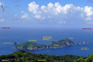
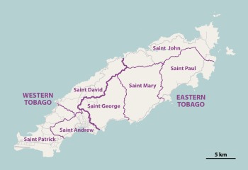 Map of Tobago (large island), Little Tobago (far right) Goat Island (between Tobago and Little Tobago) & St. Giles Island (top right). | |
Location of Tobago in the Lesser Antilles | |
| الجغرافيا | |
|---|---|
| الموقع | Eastern Caribbean |
| الإحداثيات | 11°15′00″N 60°40′01″W / 11.250°N 60.667°W |
| المساحة | 300 km2 (120 sq mi) |
| أعلى منسوب | 550 m (1٬800 ft) |
| أعلى نقطة | Pigeon Peak |
| الإدارة | |
| Island | Tobago |
| ISO 3166-2:TT | TT-TOB |
| Districts | 12 |
| العاصمة | Port of Spain |
| Largest settlement | Scarborough (pop. 17,537) |
| Prime Minister | Keith Rowley |
| السكان | |
| اسم المواطن | Tobagonian |
| التعداد | 60,874[1] (2011) |
| الكثافة السكانية | 203 /km2 (526 /sq mi) |
| اللغات | Trinidad and Tobago English, Tobagonian Creole, Antillean French Creole, Spanish[2] |
| Currency | Trinidad and Tobago Dollar (TTD) |
| Religions | Christianity, Hinduism, Islam, Spiritual-Shouter Baptist, Orisha (Yoruba), Traditional African religion, Afro-American religions, Rastafarianism, Bahá'í[3] |
| الجماعات العرقية | African, Multiracial (non-Dougla), Dougla (Indian-African), Indian, European, Amerindian, Chinese, Arabs, Hispanic/Latinos, Others[4] |
| معلومات إضافية | |
| Time zone | |
| Postal code | 90xxxx – 98xxxx[5] |
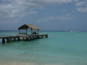
توباگو (Tobago) أو توبيگو ( /təˈbeɪɡoʊ/) هي إحدى الجزيرتين الرئيسيتين المكونتين لجمهورية ترينيداد وتوباغو. توباگو أصغر من الجزيرة الأخرى ترينيداد. تقع في جنوب البحر الكاريبي، شمال شرق ترينيداد، وجنوب غرينادا. يعتقد بأن اسم الجزيرة مستمد من كلمة "توباكو" (tobacco) بمعنى التبغ. مساحتها الإجمالية 300 كم²، وعدد سكانها 54,084 (عام 2000). عاصمتها سكاربورو التي يسكنها 17000 نسمة. للجزيرة مناخ استوائي.
المقاطعات
Historically, Tobago was divided into seven parishes (Saint Andrew, Saint David, Saint George, Saint John, Saint Mary, Saint Patrick and Saint Paul). In 1768 each parish of Tobago had nominated representatives to the Tobago House of Assembly. On 20 October 1889 the British crown implemented a Royal Order in Council constituting Tobago as a ward of Trinidad, thus terminating local government on Tobago and formed a unified colony government.
In 1945 when the county council system was first introduced, Tobago was administered as a single county of Trinidad.
In 1980 provisions were made for the Tobago House of Assembly to be revived as an entity providing local government in Tobago. Under the revived system, Tobago is made up of 12 local electoral districts with each district electing one Assemblyman to the THA.
| No. | Electoral districts[6] |
|---|---|
| 1 | Bacolet / Mount St. George |
| 2 | Goodwood /Belle Garden west |
| 3 | Bethel / Mt. Irvine |
| 4 | Black Rock / Whim / Spring Garden |
| 5 | Buccoo / Mount Pleasant |
| 6 | Canaan / Bon Accord |
| 7 | Lambeau / Signal Hill |
| 8 | Parlatuvier / L’Anse Fourmi / Speyside |
| 9 | Plymouth / Golden Lane |
| 10 | Providence / Mason Hall / Moriah |
| 11 | Belle Garden East/ Roxborough / Delaford |
| 12 | Scarborough / Calder Hall |
الديمغرافيا
The population was 60,874 at the 2011 census.[1] The capital, Scarborough, has a population of 17,537. While Trinidad is multiethnic, Tobago's population is primarily of African descent, although with a growing proportion of Trinidadians of East Indian descent and Europeans. Between 2000 and 2011, the population of Tobago grew by 12.55 percent, making it one of the fastest-growing areas of Trinidad and Tobago.
السلف
| التركيب العرقي | 2011[7] |
|---|---|
| Afro-Trinidadians and Tobagonians | 85.2% |
| Dougla (Indian and Black) | 4.2% |
| Multiracial | 4.2% |
| Indians (Indo-Trinidadian) | 2.5% |
| White Trinidadian/Tobagonian | 0.7% |
| Native American (Amerindian) | 0.1% |
| East Asian (Chinese) | 0.08% |
| Arab (Syrian/Lebanese) | 0.02% |
| Other | 0.1% |
| Not stated | 2.6% |
الاقتصاد
Tobago's main economy is based on tourism, fishing, and government spending, government spending being the largest. Tourism is still a fledgling industry and needs to be developed. The local governing body, the Tobago House of Assembly (THA), employs 62% of the labor force.
البيئة
الهامش
- ^ أ ب Trinidad and Tobago 2011 Population and Housing Census Demographic Report. Trinidad and Tobago Central Statistical Office. p. 26. Archived from the original. You must specify the date the archive was made using the
|archivedate=parameter. http://www.tt.undp.org/content/dam/trinidad_tobago/docs/DemocraticGovernance/Publications/TandT_Demographic_Report_2011.pdf?download. Retrieved on 27 May 2016. - ^ https://www.ethnologue.com/country/tt/languages
- ^ Pike, John. "Trinidad & Tobago - Religion". www.globalsecurity.org.
- ^ "The World Factbook — Central Intelligence Agency". www.cia.gov.
- ^ "List of Postal Districts". TTPOST. July 29, 2018. Retrieved July 29, 2018.
- ^ Electoral Districts in the Electoral Area of Tobago in relation to Tobago House of Assembly Elections, Elections & Boundaries Commission of T&T
- ^ Central Statistical Office. "NON-INSTITUTIONAL POPULATION BY SEX, AGE GROUP, ETHNIC GROUP AND MUNICIPALITY" (PDF).
وصلات خارجية
- Tobago Hotel & Tourism Association
- Tobago House of Assembly
- Tobago at worldstatesmen.org.
- Pages using gadget WikiMiniAtlas
- Short description is different from Wikidata
- Coordinates on Wikidata
- Articles with hatnote templates targeting a nonexistent page
- توباگو
- Islands of Trinidad and Tobago
- Former British colonies and protectorates in the Americas
- Former Dutch colonies
- مستعمرات فرنسية سابقة
- Former colonies of Courland
- 1814 establishments in the British Empire
- ترينيداد وتوباغو
- جزر الكاريبي


