بوكاڤو
(تم التحويل من بوكافو)
بوكاڤو Bukavu
Costermansville/Costermansstad | |
|---|---|
 | |
| الإحداثيات: 2°30′S 28°52′E / 2.500°S 28.867°E | |
| البلد | |
| المقاطعة | جنوب كيڤو |
| Founded | 1901 |
| الحكومة | |
| • Mayor | Nzita Kavungirwa |
| المساحة | |
| • الإجمالي | 60 كم² (20 ميل²) |
| المنسوب | 1٬498 m (4٬915 ft) |
| التعداد (2012) | |
| • الإجمالي | 806٬940 |
| • الكثافة | 13٬000/km2 (35٬000/sq mi) |
| منطقة التوقيت | UTC+2 (Lubumbashi Time) |
| الموقع الإلكتروني | Official website (بالفرنسية) (** query broken URL) |
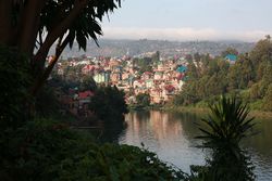
بوكاڤو (Bukavu ؛ الأسماء الرسمية السابقة: كوسترمانزڤل Costermansville (فرنسية) و كوسترمانزشتاد Costermansstad (هولندية)) هي مدينة في شرق جمهورية الكونغو الديمقراطية (DRC)، وتقع على أقصى الطرف الجنوبي الشرقي لـبحيرة كيڤو، غرب سيانگوگو في رواندا، ويفصلها عن تلك المدينة مصب نهر روزيزي. وهي عاصمة مقاطعة جنوب كيڤو وفي عام 2012 بلغ تعداد سكانها 806,940. الحاكم الحالي لبوكاڤو هي مارسلان تشيشامبو.
. . . . . . . . . . . . . . . . . . . . . . . . . . . . . . . . . . . . . . . . . . . . . . . . . . . . . . . . . . . . . . . . . . . . . . . . . . . . . . . . . . . . . . . . . . . . . . . . . . . . . . . . . . . . . . . . . . . . . . . . . . . . . . . . . . . . . . . . . . . . . . . . . . . . . . . . . . . . . . . . . . . . . . . .
التاريخ

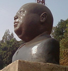
تمثال نصفي لـلوران-ديزيريه كابيلا.
| Climate data for بوكاڤو | |||||||||||||
|---|---|---|---|---|---|---|---|---|---|---|---|---|---|
| Month | Jan | Feb | Mar | Apr | May | Jun | Jul | Aug | Sep | Oct | Nov | Dec | Year |
| Mean daily maximum °C (°F) | 25 (77) |
25.1 (77.2) |
25.1 (77.2) |
24.6 (76.3) |
24.7 (76.5) |
25 (77) |
25.7 (78.3) |
26.8 (80.2) |
26.6 (79.9) |
25.6 (78.1) |
25 (77) |
24.8 (76.6) |
25.3 (77.6) |
| Daily mean °C (°F) | 19.8 (67.6) |
19.9 (67.8) |
19.9 (67.8) |
19.6 (67.3) |
19.9 (67.8) |
19.6 (67.3) |
19.5 (67.1) |
20.4 (68.7) |
20.5 (68.9) |
20.1 (68.2) |
19.8 (67.6) |
19.7 (67.5) |
19.9 (67.8) |
| Mean daily minimum °C (°F) | 14.7 (58.5) |
14.7 (58.5) |
14.7 (58.5) |
14.7 (58.5) |
15.1 (59.2) |
14.2 (57.6) |
13.4 (56.1) |
14 (57) |
14.5 (58.1) |
14.7 (58.5) |
14.6 (58.3) |
14.6 (58.3) |
14.5 (58.1) |
| Average precipitation mm (inches) | 135 (5.3) |
137 (5.4) |
170 (6.7) |
165 (6.5) |
103 (4.1) |
34 (1.3) |
17 (0.7) |
52 (2.0) |
110 (4.3) |
151 (5.9) |
172 (6.8) |
145 (5.7) |
1٬391 (54.7) |
| Source: Climate-Data.org, altitude: 1490m[1] | |||||||||||||
معالم أخرى
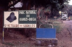
- Kahuzi-Biéga National Park, a World Heritage Site and one of two homes of the Eastern Lowland Gorilla, is close to the city and can be accessed from the road to Kavumu. The park headquarters at Tshivanga is located 31 km from Bukavu.
شخصيات
الهامش
- ^ خطأ استشهاد: وسم
<ref>غير صحيح؛ لا نص تم توفيره للمراجع المسماةClimate-Data.org
- Diallo, Siradiou (1975). Le Zaire aujourd'hui. Editions Jeune Afrique. ISBN 2-85258-021-7.
- UN Department for Humanitarian Affairs, Inter-Regional Information Network briefings IRIN
External links
مشاع المعرفة فيه ميديا متعلقة بموضوع Bukavu.
- "Detailed Map of Bukavu" (PDF). Kinshasa, Democratic Republic of the Congo: GIS Unit MONUC (United Nations Organization Stabilization Mission in the Democratic Republic of the Congo). 25 August 2003. Archived from the original (PDF) on 13 October 2007.
{{cite web}}: Unknown parameter|deadurl=ignored (|url-status=suggested) (help) - Map "Bukavu, Sud-Kivu, Congo-Kinshasa" (PDF). Reférential Geographique Commun, République Démocratique du Congo. 21 December 2012.
- (بالفرنسية) Worldwide Bukavu Community Website
- (بالألمانية) Spiegel-Online article
- (بالفرنسية) Panzi Hospital of Bukavu
- See http://www.3tamis.org, the web site of Bukavu and its area. Beautiful pictures, vidéos, stories
- Pictures of Bukavu, previously Costermansville
الكلمات الدالة:
تصنيفات:
- Pages using gadget WikiMiniAtlas
- Short description is different from Wikidata
- Articles with hatnote templates targeting a nonexistent page
- CS1 errors: unsupported parameter
- Coordinates on Wikidata
- بوكاڤو
- Populated places established in 1901
- Populated places in South Kivu
- Populated places on Lake Kivu
- نهر روزيزي
- كيڤو الجنوبية


