بحيرة نايڤاشا
| Lake Naivasha | |
|---|---|
 الغروب على بحيرة نايڤاشا | |
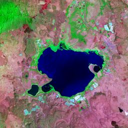
 صورة ساتلية لبحيرة نايڤاشا | |
| الاحداثيات | 0°46′6.70″S 36°21′2.32″E / 0.7685278°S 36.3506444°E |
| بلدان الحوض | كينيا |
| مساحة السطح | 139 km2 (54 sq mi) |
| متوسط العمق | 6 m (20 ft) |
| أقصى عمق | 30 m (98 ft) |
| ارتفاع السطح | 1,884 m (6,181 ft) |
| التجمعات السكنية | نايڤاشا |
بحيرة نايڤاشا Lake Naivasha هي a freshwater lake في كينيا، على طرف بلدة نايڤاشا in Nakuru County, which lies north west of Nairobi. It is part of the Great Rift Valley. The name derives from the local Maasai name Nai'posha, meaning "rough water" because of the sudden storms which can arise.
. . . . . . . . . . . . . . . . . . . . . . . . . . . . . . . . . . . . . . . . . . . . . . . . . . . . . . . . . . . . . . . . . . . . . . . . . . . . . . . . . . . . . . . . . . . . . . . . . . . . . . . . . . . . . . . . . . . . . . . . . . . . . . . . . . . . . . . . . . . . . . . . . . . . . . . . . . . . . . . . . . . . . . . .
الموقع
Lake Naivasha is at the highest elevation of the Kenyan Rift valley at 1,884 metres (6,181 ft) in a complex geological combination of volcanic rocks and sedimentary deposits from a larger Pleistocene era lake. Apart from transient streams, the lake is fed by the perennial Malewa and Gilgil rivers. There is no visible outlet, but since the lake water is relatively fresh it is assumed to have an underground outflow.[1]
The lake has a surface area of 139 km², [2]
البيئة
The lake is home to a variety of types of wildlife including over 400 different species of bird and a sizeable population of hippos.
الهامش
- ^ Harper 2003, p. 1.
- ^ "THE OUTFLOW OF LAKE NAIVASHA BASED ON THE STABLE ISOTOPE COMPOSITION" (characteristics), M.K. Arusei, J. K Sanga, M.P Tole, Department of Chemistry, School of Environmental Studies, Moi University, P.O Box 3900 Eldoret, Kenya, webpage: UNEP-Moi-Arusei-PDF.
المصادر
- Harper, David M. (2003). Lake Naivasha, Kenya. Springer. ISBN 1-4020-1236-5.
{{cite book}}: Invalid|ref=harv(help)


