الاحتلال المجري للأراضي اليوغسلافية
الاحتلال المجري للأراضي اليوغسلافية | |
|---|---|
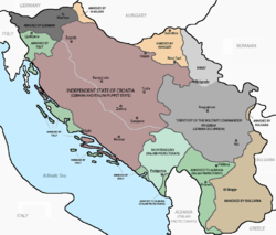 احتلال وتقسيم يوغسلافيا في 1941. مناطق يوغسلافيا التي احتلتها ثم ضمتها المجر يظهرون باللون البرتقالي الشاحب في الشمال (باتشكا وBaranja) وشمال غرب (Međimurje وPrekmurje). | |
| البلد | |
| احتلتها المجر | 11 أبريل 1941 |
| ضمتها المجر | 14 ديسمبر 1941 |
| احتلتها ألمانيا | 15 مارس 1944 |
| أقاليم | |
| الحكومة | |
| • النوع | أدمجت في المقاطعات المجرية المتواجدة |
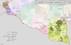
| • الكيان | Bács-Bodrog, Baranya, Zala, Vas |
| المساحة | |
| • الإجمالي | 11٬475 كم² (4٬431 ميل²) |
| التعداد (1941) | |
| • الإجمالي | حوالي 1٬145٬000 |
| انظر قسم الديمغرافيا | |
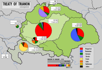
الاحتلال المجري للأراضي اليوغسلافية تكون من الاحتلال العسكري ثم ضم مناطق باتشكا، Baranja, Međimurje and Prekmurje في مملكة يوغسلافيا من قِبل المجر أثناء الحرب العالمية الثانية. These territories had all been under Hungarian rule prior to 1920, and had been transferred to Yugoslavia as part of the post-الحرب العالمية الأولى معاهدة تريانون. They now form part of several states: Yugoslav Bačka is now part of Vojvodina, an autonomous province of صربيا, Yugoslav Baranja and Međimurje are part of modern-day Croatia, and Yugoslav Prekmurje is جزء من سلوڤينيا الحالية. The occupation began on 11 April 1941 when 80,000 Hungarian troops crossed the Yugoslav border in support of the German-led Axis غزو يوغسلاڤيا that had commenced five days earlier. وكانت هناك بعض المقاومة ضد القوات المجرية من الچتنك الصرب غير النظاميين، ولكن دفاعات الجيش اليوغسلاڤي الملكي كانت قد انهارت في ذلك الوقت. The Hungarian forces were indirectly aided by the local Volksdeutsche, the الأقلية الألمانية, which had formed a militia and disarmed around 90,000 Yugoslav troops. Despite only sporadic resistance, Hungarian troops killed many civilians during these initial operations, including some Volksdeutsche. The government of the newly formed Axis puppet state, the دولة كرواتيا المستقلة، subsequently consented to the Hungarian annexation of the Međimurje area، التي أغضبت السكان الكروات في المنطقة.
. . . . . . . . . . . . . . . . . . . . . . . . . . . . . . . . . . . . . . . . . . . . . . . . . . . . . . . . . . . . . . . . . . . . . . . . . . . . . . . . . . . . . . . . . . . . . . . . . . . . . . . . . . . . . . . . . . . . . . . . . . . . . . . . . . . . . . . . . . . . . . . . . . . . . . . . . . . . . . . . . . . . . . . .
الخلفية
الغزو
الجغرافيا
المقاطعات
|
Bács-Bodrog County:
|
Baranya County:
Vas County:
|
Zala County:
|
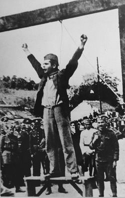
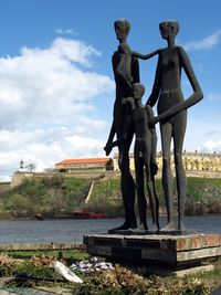
المقاومة والاضطهاد
الأعقاب
الاحتلال الألماني
انظر أيضاً
المراجع
الهامش
- ^ Lemkin 2008, p. 631.
- Short description is different from Wikidata
- Pages using infobox settlement with no coordinates
- Articles with hatnote templates targeting a nonexistent page
- Yugoslavia in World War II
- The Holocaust in Yugoslavia
- World War II occupied territories
- History of Bačka
- History of Baranya (region)
- Slovenia in World War II
- Hungary in World War II
- Serbia in World War II
- World War II crimes
- 1940s in Croatia
- 1940s in Slovenia
- 1941 establishments in Yugoslavia
- 1944 disestablishments in Yugoslavia
- 20th century in Vojvodina
- Hungary–Yugoslavia relations
