الألپ الڤكتورية
| Victorian Alps | |
|---|---|
| Victoria Alps, High Plains, High Country, The Alps | |
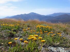
 Mount Hotham, looking towards Mount Feathertop (2nd highest peak) in summer; during winter the alps are covered in snow. | |
| أعلى نقطة | |
| القمة | Mount Bogong |
| الارتفاع | 1,986 m (6,516 ft) [1] AHD |
| الإحداثيات | 36°43′56″S 147°18′21″E / 36.73222°S 147.30583°E [2] |
| الأبعاد | |
| الطول | 400 km (250 mi) NE-SW (approx) |
| العرض | 200 km (120 mi) E-W (approx) |
| المساحة | 5,199 km2 (2,007 sq mi) [3] |
| الجغرافيا | |
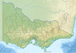
Location of the Victorian Alps in Victoria | |
| البلد | Australia |
| المنطقة | Victoria |
| نطاق الإحداثيات | 36°44′S 147°18′E / 36.733°S 147.300°E [4] |
| السلسلة الأم | Great Dividing Range |
| يحد | نيو ساوث ويلز |
| الجيولوجيا | |
| عمر الصخر | Devonian |
| نوع الصخر | Igneous, Sedimentary and Metamorphic |
الألپ الڤكتورية Victorian Alps، هي سلسلة جبال ممتدة تشكل الجزي الجنوبي من الألپ الأسترالية وتوجد في ولاية ڤكتوريا الأسترالية، وهي جزء من سلسلة جبال الفاصل الكبير، an Interim Biogeographic Regionalisation for Australia (IBRA) sub-bioregion of approximately 519,866 hectares (1,284,620 acres),[3] and an administrative sub-region bordering the Gippsland and Hume regions.
. . . . . . . . . . . . . . . . . . . . . . . . . . . . . . . . . . . . . . . . . . . . . . . . . . . . . . . . . . . . . . . . . . . . . . . . . . . . . . . . . . . . . . . . . . . . . . . . . . . . . . . . . . . . . . . . . . . . . . . . . . . . . . . . . . . . . . . . . . . . . . . . . . . . . . . . . . . . . . . . . . . . . . . .
الموقع والسمات
Comprising the Bogong High Plains, Bowen Range, Cathedral Range, Cobberas Range, and numerous other smaller ranges, the Victorian Alps include the Alpine Shire, parts of the East Gippsland Shire, and some parts of the Mansfield Shire local government areas. The alps are sometimes called the High Plains or High Country,
The highest peak in the range is Mount Bogong at an elevation of 1,986 metres (6,516 ft) AHD, which is also the highest peak in Victoria.[1]
انظر أيضاً
المراجع
- ^ أ ب "Mount Bogong, Australia". Peakbagger.com.
- ^ قالب:Gazetteer of Australia
- ^ أ ب "Australia's bioregions (IBRA)". Department of Sustainability, Environment, Water, Population and Communities. Commonwealth of Australia. 2012. Retrieved 21 January 2014.
- ^ "Victoria Alps (sic)". Peakbagger.com.
- Pages using gadget WikiMiniAtlas
- Coordinates on Wikidata
- Pages using infobox mountain with multiple parameters
- Pages using infobox mountain with deprecated parameters
- Pages with empty portal template
- الألپ الڤكتورية
- Mountain ranges of Victoria (Australia)
- Central Highlands (Victoria)
- Great Dividing Range
- East Gippsland
- هيوم (منطقة)
- IBRA subregions
