الألپ الفرنسية
| الألپ الفرنسية | |
|---|---|
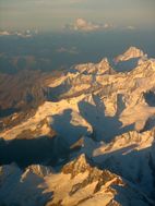
 صورة جوية لماسيف مون بلان، أعلى جبال الألب الفرنسية، كما يبدو من الغرب | |
| أعلى نقطة | |
| القمة | مون بلان |
| الارتفاع | 4,810.45 m (15,782.3 ft) |
| الجغرافيا | |
خطأ لوا في وحدة:Location_map على السطر 526: Unable to find the specified location map definition: "Module:Location map/data/Massif des Alpes map-fr.svg" does not exist.
| |
| يحد | الألپ السويسرية، الألپ الإيطالية |
| الجيولوجيا | |
| التجبل | Alpine orogeny |
| عمر الصخر | Tertiary |
| نوع الصخر | Bündner schist, flysch and molasse |

الألپ الفرنسية هي أجزاء من سلسلة جبال الألپ الواقعة في فرنسا، وتقع منطقتي رون-ألپ وپروڤانس-ألپ-كوت دازور. وبينما تقع بعض سلاسل جبال الألپ الفرنسية بالكامل في فرنسا، ، فالبعض الآخر مثل ماسيف مون بلان، تتقاسمه سويسرا و/أو إيطاليا.
وبارتفاع 4808 متر، فإن مون بلان (بالإيطالية: مونتى بيانكو Monte Bianco)، على الحدود الفرنسية -الإيطالية، هو أعلى الجبال في الألپ، وأعلى جبل في اوروپا الغربية.[1]
البلدات البارزة في الألب الفرنسية تضم گرنوبل، شاموني، آنسي، شامبيري، إيڤيان-لو-بان وألبيرڤيل.
سلاسل الجبال والقمم
مناطق التزلج
The largest connected ski areas are:
- Les Trois Vallées (Courchevel, Méribel, La Tania, Brides-les-Bains, Saint-Martin-de-Belleville, Les Menuires, Val Thorens and Orelle): 338 slopes, 600 km of pistes.
- Portes du Soleil (Avoriaz, Châtel, Morzine, Les Gets, Saint-Jean d'Aulps, La Chapelle d'Abondance, Abondance, Montriond, Swiss resorts): 288 slopes, 650 km of slopes not entirely connected.
- Paradiski (La Plagne, Peisey-Vallandry, Les Arcs), Champagny-en-Vanoise: 239 slopes, 420 km of slopes.
- Via Lattea (Montgenèvre, Italian resorts): 214 slopes, 400 km of slopes.
- Évasion Mont-Blanc (Combloux, Megève, Saint-Gervais, Saint-Nicolas-de-Véroce, Les Contamines Monjoie): 183 slopes, 420 km of slopes not entirely connected.
- Espace Killy (Tignes, Val-d'Isère): 137 slopes, 300 km of slopes.
- Grand Massif (Flaine, Les Carroz, Morillon, Samoëns, Sixt): 134 slopes, 265 km of slopes.
- Les Aravis (La Clusaz, Manigod, La Croix Fry, Merdassier, Le Grand-Bornand): 133 slopes, 220 km of slopes not entirely connected.
- Les Grandes Rousses (L'Alpe d'Huez, Vaujany, Auris-en-Oisans, Oz-en-Oisans, Villard-Reculas): 117 slopes, 236 km of slopes.
- Serre Chevalier: 111 slopes, 250 km of slopes.
- La Forêt Blanche (Risoul, Vars): 104 slopes, 180 km of slopes.
- Les Sybelles (Le Corbier, La Toussuire, Les Bottières, Saint-Jean-d'Arves, Saint-Sorlin-d'Arves, Saint-Colomban-des-Villards): 96 slopes, 310 km of slopes.
- Valloire and Valmeinier: 83 slopes, 150 km of slopes.
- Grand Domaine (Valmorel, Saint-François-Longchamp): 82 slopes, 150 km of slopes
- Espace San Bernardo (La Rosière, La Thuile - Italy): 73 slopes, 150 km of slopes.
- Les Deux Alpes and La Grave: 69 slopes, 220 km of slopes.
The other large ski areas are:
- Le Val d'Arly (Praz-sur-Arly, Notre-Dame-de-Bellecombe, Flumet): 150 km of slopes.
- L'Espace Cristal (Les Saisies, Crest-Voland): 80 km of slopes
- L'Espace Diamant is a combination of Espace Val d'Arly and Espace Cristal with 185 km of slopes
- Villard-de-Lans et Corrençon-en-Vercors: 125 km of slopes
- Valberg - Beuil les Launes: 90 km of slopes
- Espace Lumière (Pra Loup, Val d'Allos): 170 km of slopes
- Superdévoluy - La Joue du Loup: 100 km of slopes
الأنشطة
A range of winter and summer activities are available in the French Alps. In the winter, these include skiing and snowboarding as well as alternatives such as snowshoeing, sledging.[2] Summer activities include hiking, mountaineering, biking and rock climbing.[3]
معرض صور
Mont Blanc (4,810 m)
Aiguille du Dru (3,754 m)
Aiguille Verte (4,122 m)
Mer de Glace, Dent du Géant (4,013 m) and Grandes Jorasses (4,208 m) in Chamonix (c. 1890)
Tramway du Mont-Blanc, at Bellevue Station (1,794 m) in Saint-Gervais-les-Bains
Jacques Balmat at the side of Horace-Benedict de Saussure, "The Father of Alpinism", in a monument erected at Chamonix
Grand Capucin (3,838 m) and its 400-meter vertical face
Alpine ibex in Aussois, Savoie
Chalet in the medieval city of Yvoire
انظر أيضاً
- La Grande Odyssée
- 1924 Winter Olympics
- 1968 Winter Olympics
- 1992 Winter Olympics
- List of highest paved roads in Europe
- List of mountain passes
- List of national parks in the Alps
- List of ski areas and resorts in Europe
الهامش
- ^ Mont Blanc shrinks by 45cm in two years
- ^ "frenchalps.co.uk - Your website dedicated to information on the French Alps". frenchalps.co.uk (in الإنجليزية الأمريكية). Retrieved 2016-01-27.
- ^ "French Alps Mountain Activities | frenchalps.co.uk". frenchalps.co.uk (in الإنجليزية الأمريكية). Retrieved 2016-01-27.
- Raoul Blanchard (1938–1956), Les Alpes Occidentales. Paris: Édition Arthaud. (French)
- Roger Frison-Roche (1964), Les montagnes de la terre. Paris: Flammarion. (French)
- Sergio Marazzi (2005), Atlante Orografico delle Alpi. SOIUSA. Pavone Canavese (TO): Priuli & Verlucca editori. ISBN 978-88-8068-273-8 (Italian)
- Sergio Marazzi, La "Suddivisione orografica internazionale unificata del Sistema Alpino" (SOIUSA) - article with maps and illustrations, PDF (Italian)
وصلات خارجية
 Media related to Alps of France at Wikimedia Commons
- CS1 الإنجليزية الأمريكية-language sources (en-us)
- Pages using infobox mountain with multiple parameters
- Pages using infobox mountain with unknown parameters
- Pages using infobox mountain with deprecated parameters
- سلاسل جبال الألپ
- مناطق ومنتجعات التزلج في فرنسا
- سلاسل الجبال في أوڤرن-رون-ألپ
- سلاسل الجبال في پروڤانس-ألپ-كوت دازور


