إعصار مراكوت (2009)
(تم التحويل من إعصار ماركوت 2009)
| Typhoon (بمقياس JMA) | |
|---|---|
| تصنيف 2 إعصار (SSHWS) | |
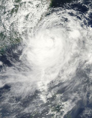
 Typhoon Morakot near peak intensity. | |
| تشكـّل | 2 اغسطس، 2009 |
| تشتـّت | لازال نشطا |
| أعلى رياح | 10-minute sustained: 165 كم/س (105 ميل/س) 1-minute sustained: 175 كم/س (110 ميل/س) |
| أقل ضغط | 945 hPa (مبار); 27.91 inHg |
| الوفيات | 40 ضحايا>656 مفقدون |
| الأضرار | $421.8 million (2009 USD) |
| المناطق المتأثرة | الفلبين, تايوان, الصين |
| جزء من موسم تايفون المحيط الهادي 2009 | |
إعصار مراكوت (التسمية العالمية: 0908، JTWC designation: 09W, PAGASA name: Kiko)، هو إعصار بدأت في 2 اغسطس 2009، ويصنف تحت الأعاصير المدارية. خلال اليوم الأول بدأت بعاصفة مدارية ضربت سواحل الفلبين وتايوان ثم إنتقلت إلى الصين. سمي مراكوت عن طريق وكالة الأرصاد اليابانية في نهاية يوم 3 اغسطس.
. . . . . . . . . . . . . . . . . . . . . . . . . . . . . . . . . . . . . . . . . . . . . . . . . . . . . . . . . . . . . . . . . . . . . . . . . . . . . . . . . . . . . . . . . . . . . . . . . . . . . . . . . . . . . . . . . . . . . . . . . . . . . . . . . . . . . . . . . . . . . . . . . . . . . . . . . . . . . . . . . . . . . . . .
التاريخ

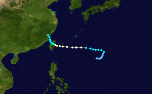
خريطة توقـِّع مسار وشدة العاصفة، حسب مقياس سفير-سمپسون للأعاصير
التأثير والتسجيلات
| المدة (ساعة) |
اسم العاصفة السنة |
Record prior to Morakot |
الإجمالي | +/- (في م. م) | ||
|---|---|---|---|---|---|---|
| م.م | في | م. م. | في | |||
| 24 | Denise (1966) | 1825 | 71.8 | 2540 | 100.0 | +175 |
| 48 | Unnamed (1958) | 2467 | 97.1 | 2900 | 114.17 | +433 |
| 72 | Gamede (2007) | 3929 | 154.6 | — | — | — |
| 96 | Gamede (2007) | 4869 | 191.7 | — | — | — |
| Total | Hyacinthe (1980) | 5678 | 223.5 | 2900+ | 114.17+ | -2778 |
الفلبين
تايوان
| Wettest tropical cyclones in Taiwan Highest known recorded totals | ||||
|---|---|---|---|---|
| Precipitation | Storm | Location | ||
| Rank | (mm) | (in) | ||
| 1 | 2900 | 114.17 | مراكوت 2009 | Wei Liao Mountain[1] |
| 2 | 1736 | 68.35 | Herb 1996 | Mount A-Li[2] |
| 3 | 1730 | 68.00 | Lynn 1987 | [3] |
| 4 | 1672 | 65.83 | Carla 1967 | Xinliao[4] |
| 5 | 1611 | 63.42 | Sinlaku/Marce 2008 | Hopin town[5] |
| 6 | 1546 | 60.87 | Aere/Marce 2004 | Matala[6] |
| 7 | 1431 | 56.34 | Nari 2001 | [7] |
| 8 | 1248 | 49.13 | Gloria 1963 | Baxin[4] |
| 9 | 1124 | 44.27 | Jangmi/Ofel 2008 | Tatung Town[8] |
| 10 | 1090 | 42.91 | Nanmadol 2004 | Puluowan[9] |
الصين
انظر أيضا
- موسم تايفون المحيط الهادي 200
- Timeline of the 2009 Pacific typhoon season
- إعصار مداري (تايفون المحيط الهادي)
- كارثة طبيعية
المصادر
- ^ Staff Writer (August 9, 2009). "Record typhoon rain leaves trail of destruction across Southern Taiwan". Taiwan News. Retrieved August 9, 2009.
{{cite web}}: Italic or bold markup not allowed in:|publisher=(help) - ^ Chun-Chieh Wu, Tzu-Hsiung Yen, Ying -Hwa Kuo, and Wei Wang. Rainfall Simulation Associated With Typhoon Herb (1996) near Taiwan. Part I: The Topographic Effect. Retrieved on 2007-02-24.
- ^ Joint Typhoon Warning Center. Super Typhoon Lynn. Retrieved on 2007-01-19.
- ^ أ ب Chen Lianshou. FIFTH INTERNATIONAL WORKSHOP ON TROPICAL CYCLONES. Retrieved on 2007-01-27.
- ^ "Typhoon Sinlaku Central emergency operation center No.12". Central emergency operation center. 2008-09-16. Retrieved 2009-01-13.
- ^ Padgett, Gary (2005-05-17). "Monthly Global Tropical Cyclone Summary: November 2004". Australian Severe Weather Index. Jimmy Deguara. Retrieved 2007-01-13.
{{cite web}}: Unknown parameter|coauthors=ignored (|author=suggested) (help) - ^ A Modeling Study on Typhoon Nari (2001): Landfall Characteristics. Retrieved on 2007-02-25.
- ^ "Typhoon Jangmi Central emergency operation center No.4". Central emergency operation center. 2008-09-29. Retrieved 2009-01-13.
- ^ Padgett, Gary (2005-05-17). "Monthly Global Tropical Cyclone Summary August 2004". Australian Severe Weather Index. Jimmy Deguara. Retrieved 2007-01-13.
{{cite web}}: Unknown parameter|coauthors=ignored (|author=suggested) (help)
وصلات خارجية
- Typhoon Morakot Relief Efforts
- Japan Meteorological Agency (RSMC Tokyo)
- National Weather Service Guam
- China Meteorological Agency
- Korea Meteorological Agency
- Philippine Atmospheric, Geophysical and Astronomical Services Administration (PAGASA)
- Taiwan Central Weather Bureau
- Joint Typhoon Warning Centre
الكلمات الدالة: