إحداثيات مجرية
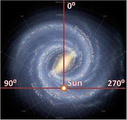
الإحداثيات المجرّية Galactic coordinates هى نظام إحداثيات فلكية لقياس موقع الأجرام السماوية الموجودة في المجرة (مجرة درب التبانة) كما تبدو من الكرة الارضية. والإحداثيات المجرية تستعمل العرض المقيس شمالا وجنوبا أبتداء من خط الأستواء المجرى والطول المقيس من جهه تزايد ( الصعود المستقيم) من الصفر الى 360 درجة.
. . . . . . . . . . . . . . . . . . . . . . . . . . . . . . . . . . . . . . . . . . . . . . . . . . . . . . . . . . . . . . . . . . . . . . . . . . . . . . . . . . . . . . . . . . . . . . . . . . . . . . . . . . . . . . . . . . . . . . . . . . . . . . . . . . . . . . . . . . . . . . . . . . . . . . . . . . . . . . . . . . . . . . . .
خط الطول المجرّي
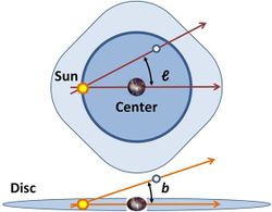
Longitude (symbol l) measures the angular distance of an object eastward along the galactic equator from the galactic center. Analogous to terrestrial longitude, galactic longitude is usually measured in degrees (°).
خط العرض المجرّي
Latitude (symbol b) measures the angle of an object north or south of the galactic equator (or midplane) as viewed from Earth; positive to the north, negative to the south. For example, the north galactic pole has a latitude of +90°. Analogous to terrestrial latitude, galactic latitude is usually measured in degrees (°).
تعريف

| صعود مستقيم | ميل | الكوكبة | ||||
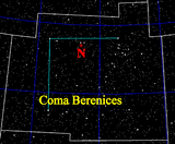
| القطب الشمالي (خط عرض +90°) | 12h 49m
(12h 51m.4) |
+27°.4
(+27°.13) |
كوكبة الهلبة | |||
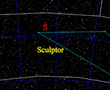
| القطب الجنوبي (خط عرض -90°) | 0h 49m
(0h 51m.4) |
-27°.4
(-27°.13) |
معمل النحات | |||
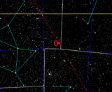
| مركز مجرّي (خط الطول 0°) | 17h 42m.4
(17h 45m.6) |
-28°.92
(-28°.94) |
كوكبة الرامي | |||
| المركز المقابل (خط الطول 180°) | 5h 42m.4
(5h 45m.6) |
+28°.92
(+28°.94) |
ممسك الأعنة | |||
| ||||||
التحويل بين الإحداثيات الإستوائية والمجرّية
An object's location expressed in the equatorial coordinate system can be transformed into the galactic coordinate system. In these equations, α is right ascension, δ is declination. NGP refers to the coordinate values of the north galactic pole and NCP to those of the north celestial pole.[5]
The reverse (galactic to equatorial) can also be accomplished with the following conversion formulas.
الإحداثيات المستطيلة
In some applications use is made of rectangular coordinates based on galactic longitude and latitude and distance. In some work regarding the distant past or future the galactic coordinate system is taken as rotating so that the x-axis always goes to the centre of the galaxy.[6]
There are two major rectangular variations of galactic coordinates, commonly used for computing space velocities of galactic objects. In these systems the xyz-axes are designated UVW, but the definitions vary by author. In one system, the U axis is directed toward the galactic center (l = 0°), and it is a right-handed system (positive towards the east and towards the north galactic pole); in the other, the U axis is directed toward the galactic anticenter (l = 180°), and it is a left-handed system (positive towards the east and towards the north galactic pole).[7]
في الكوكبات
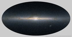
The galactic equator runs through the following constellations:[8]
انظر أيضا
- درب التبانة
- خط استواء المجرة
- إحداثيات
- Supergalactic coordinate system
- نظام إحداثيات سماوية
- تشكل وتطور المجرات
- Gould Belt
- قرص (مجرة)
- bulge (astronomy)
- galactic halo
- galactic corona
- Zone of Avoidance
المصادر
- مؤمن, عبد الأمير (2006). قاموس دار العلم الفلكي. بيروت، لبنان: دار العلم للملايين.
{{cite book}}: Cite has empty unknown parameter:|طبعة أولى coauthors=(help)
- ^ Peter Schneider (2006). Extragalactic Astronomy and Cosmology. Springer. p. 4, Figure 1.4. ISBN 3540331743.
- ^ Theo Koupelis, Karl F Kuhn (2007). In Quest of the Universe. Jones & Bartlett Publishers. p. 492; Figure 16-13. ISBN 0763743879.
- ^ Mark H. Jones, Robert J. Lambourne, David John Adams (2004). An Introduction to Galaxies and Cosmology. Cambridge University Press. p. 21; Figure 1.13. ISBN 0521546230.
{{cite book}}: CS1 maint: multiple names: authors list (link) - ^ خطأ استشهاد: وسم
<ref>غير صحيح؛ لا نص تم توفيره للمراجع المسماةBlaauwetal - ^ Carroll, Bradley; Ostlie, Dale (2007). An Introduction to Modern Astrophysics (2nd ed.). Pearson Addison-Wesley. p. 900-901. ISBN 978-0805304022.
- ^ For example Bobylev, Vadim V. (March 2010). "Searching for Stars Closely Encountering with the Solar System". Astronomy Letters. 36 (3): 220–226. arXiv:1003.2160. Bibcode:2010AstL...36..220B. doi:10.1134/S1063773710030060. S2CID 118374161.
- ^ خطأ استشهاد: وسم
<ref>غير صحيح؛ لا نص تم توفيره للمراجع المسماةJohnson - ^ خطأ استشهاد: وسم
<ref>غير صحيح؛ لا نص تم توفيره للمراجع المسماةSEDS
