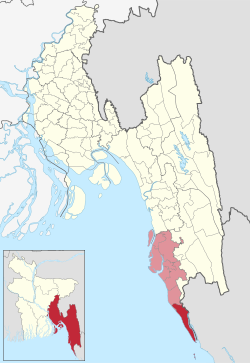
أوپاضلع تكناف
Teknaf
টেকনাফ | |
|---|---|
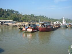
 منظر المرفأ في تكناف، بنجلادش | |
 | |
| الإحداثيات: 20°52′N 92°18′E / 20.867°N 92.300°E | |
| البلد | |
| الضلع | تشيتاگونگ |
| الضلع | كوكس بازار |
| المساحة | |
| • الإجمالي | 388٫66 كم² (150٫06 ميل²) |
| التعداد (2011) | |
| • الإجمالي | 264٬389 |
| • الكثافة | 680/km2 (1٬800/sq mi) |
| منطقة التوقيت | UTC+6 (BST) |
| الموقع الإلكتروني | teknaf |
تكناف ( Teknaf ؛ بالبنغالية: টেকনাফ Ṭeknaf) هو أوپاضلع في ضلع كوكس بازار في قسم تشيتاگونگ، بنجلادش. وتشكل أقصى النقاط جنوباً في بر بنجلادش الرئيسي (جزيرة سانت مارتن هي النقطة القصوى جنوباً). اسم المنطقة يأتي من نهر ناف الذي يشكل الحد الشرقي للأوباضلع. وتتقاسم الحدود مع ميانمار، مقابل بلدة Maungdaw.
. . . . . . . . . . . . . . . . . . . . . . . . . . . . . . . . . . . . . . . . . . . . . . . . . . . . . . . . . . . . . . . . . . . . . . . . . . . . . . . . . . . . . . . . . . . . . . . . . . . . . . . . . . . . . . . . . . . . . . . . . . . . . . . . . . . . . . . . . . . . . . . . . . . . . . . . . . . . . . . . . . . . . . . .
الجغرافيا
Teknaf is located at 20°52′00″N 92°18′00″E / 20.8667°N 92.3000°E. It has 23,675 households ومساحة إجمالية 388.66 كم². The tidal range at the Teknaf coastal area is strongly influenced by the Naaf river estuary. The area has a warm tropical climate and sufficient rainfall to enable it to support a wide biological diversity.
Teknaf Peninsula is one of the longest sandy beach ecosystems (80 km) in the world. It represents a transitional ground for the fauna of the Indo-Himalayan and Indo-Malayan ecological sub-regions. Important habitats at the site include mangrove, mudflats, beaches and sand dunes, canals and lagoons and marine habitat. Mangrove forest occurs in Teknaf peninsula both as natural forest with planted stands and mostly distributed in the inter-tidal zone. The Teknaf peninsula mangroves support the habitat of 161 different species of fish.[1] Teknaf reserved forest is one of the oldest reserved forests in Bangladesh.[2]
المناخ
Teknaf has a tropical monsoon climate (Am) with warm, dry winters and warm, extremely rainy summers.
| Climate data for تكناف (1991–2020) | |||||||||||||
|---|---|---|---|---|---|---|---|---|---|---|---|---|---|
| Month | Jan | Feb | Mar | Apr | May | Jun | Jul | Aug | Sep | Oct | Nov | Dec | Year |
| Record high °C (°F) | 32.2 (90.0) |
36.2 (97.2) |
38.0 (100.4) |
37.8 (100.0) |
36.2 (97.2) |
37.2 (99.0) |
33.6 (92.5) |
34.2 (93.6) |
35.2 (95.4) |
38.8 (101.8) |
34.8 (94.6) |
33.5 (92.3) |
38.8 (101.8) |
| Mean daily maximum °C (°F) | 27.4 (81.3) |
29.3 (84.7) |
31.2 (88.2) |
32.3 (90.1) |
32.5 (90.5) |
30.9 (87.6) |
30.1 (86.2) |
30.3 (86.5) |
31.0 (87.8) |
31.6 (88.9) |
30.5 (86.9) |
28.2 (82.8) |
30.4 (86.7) |
| Daily mean °C (°F) | 20.7 (69.3) |
22.8 (73.0) |
25.8 (78.4) |
28.1 (82.6) |
28.8 (83.8) |
28.0 (82.4) |
27.4 (81.3) |
27.5 (81.5) |
27.8 (82.0) |
27.6 (81.7) |
25.2 (77.4) |
21.9 (71.4) |
26.0 (78.8) |
| Mean daily minimum °C (°F) | 14.7 (58.5) |
16.7 (62.1) |
20.7 (69.3) |
24.1 (75.4) |
25.5 (77.9) |
25.6 (78.1) |
25.3 (77.5) |
25.3 (77.5) |
25.3 (77.5) |
24.6 (76.3) |
21.0 (69.8) |
16.6 (61.9) |
22.1 (71.8) |
| Record low °C (°F) | 9.7 (49.5) |
10.0 (50.0) |
13.5 (56.3) |
16.2 (61.2) |
17.7 (63.9) |
21.2 (70.2) |
22.0 (71.6) |
19.0 (66.2) |
21.5 (70.7) |
19.4 (66.9) |
14.5 (58.1) |
11.5 (52.7) |
9.7 (49.5) |
| Average precipitation mm (inches) | 6 (0.2) |
11 (0.4) |
21 (0.8) |
55 (2.2) |
321 (12.6) |
970 (38.2) |
1٬215 (47.8) |
932 (36.7) |
496 (19.5) |
289 (11.4) |
54 (2.1) |
12 (0.5) |
4٬386 (172.7) |
| Average precipitation days (≥ 1 mm) | 1 | 1 | 1 | 4 | 13 | 22 | 26 | 26 | 18 | 10 | 3 | 1 | 126 |
| Average relative humidity (%) | 69 | 68 | 73 | 77 | 81 | 88 | 90 | 89 | 87 | 83 | 77 | 71 | 79 |
| Mean monthly sunshine hours | 275.5 | 259.4 | 270.2 | 264.1 | 234.5 | 152.8 | 145.5 | 150.3 | 174.9 | 239.4 | 253.8 | 269.2 | 2٬689٫6 |
| Source 1: NOAA[3] | |||||||||||||
| Source 2: Bangladesh Meteorological Department (humidity 1981–2010)[4] | |||||||||||||
السكان
As of the 2011 Bangladesh census, Teknaf upazila had 46,328 households and a population of 264,389. 85,875 (32.48%) were under 10 years of age. Teknaf had an average literacy rate of 26.68%, compared to the national average of 51.8%, and a sex ratio of 986 females per 1000 males. 51,440 (19.46%) of the population lived in urban areas.[5] Ethnic population is 3,008 (1.14%), of which 1,609 were Tanchangya, 1,003 Rakhine and 235 Chakma.[6]
According to the 1991 Bangladesh census, Teknaf had a population of 152,557. Males constituted 51.81% of the population, and females 48.19%. The population aged 18 or over was 64,417. Teknaf had an average literacy rate of 16.6% (7+ years), against the national average of 32.4%.[7]
الإدارة
Teknaf Upazila is divided into Teknaf Municipality and six union parishads: Baharchara, Hnila, Sabrang, Saint Martin, Teknaf, and Whykong. The union parishads are subdivided into 12 mauzas and 146 villages.[5]
Teknaf Municipality is subdivided into 9 wards and 16 mahallas.[5]
انظر أيضاً
. . . . . . . . . . . . . . . . . . . . . . . . . . . . . . . . . . . . . . . . . . . . . . . . . . . . . . . . . . . . . . . . . . . . . . . . . . . . . . . . . . . . . . . . . . . . . . . . . . . . . . . . . . . . . . . . . . . . . . . . . . . . . . . . . . . . . . . . . . . . . . . . . . . . . . . . . . . . . . . . . . . . . . . .
المراجع
- ^ Chowdhury, N. Shah Nawaz; Hossain, M. Shahadat; Das, Nani Gopal; Barua, Prabal (2010-09-25). "Environmental variables and fisheries diversity of the Naaf River Estuary, Bangladesh" (PDF). Journal of Coastal Conservation. 15 (1): 163–180. doi:10.1007/s11852-010-0130-3. Retrieved 2011-01-01.
- ^ "Teknef forest".
- ^ "World Meteorological Organization Climate Normals for 1991-2020 — Teknaf". National Oceanic and Atmospheric Administration. Retrieved June 16, 2024.
- ^ "Normal Monthly Humidity". Bangladesh Meteorological Department. Retrieved 31 January 2016.
- ^ أ ب ت ث "Bangladesh Population and Housing Census 2011 Zila Report – Cox's Bazar" (PDF). bbs.gov.bd. Bangladesh Bureau of Statistics.
- ^ "Community Tables: Cox's Bazar district" (PDF). bbs.gov.bd. Bangladesh Bureau of Statistics. 2011. p. 103.
- ^ "Population Census Wing, BBS". Archived from the original on 2005-03-27. Retrieved November 10, 2006.
وصلات خارجية
 Media related to أوپاضلع تكناف at Wikimedia Commons
 أوپاضلع تكناف travel guide from Wikivoyage
- Mainuddin, Md. (2012). "Teknaf Upazila". In Islam, Sirajul; Jamal, Ahmed A. (eds.). Banglapedia: National Encyclopedia of Bangladesh (Second ed.). Asiatic Society of Bangladesh.
قالب:Cox's Bazar District قالب:Upazilas of Chittagong Division قالب:Border Crossings of Myanmar

