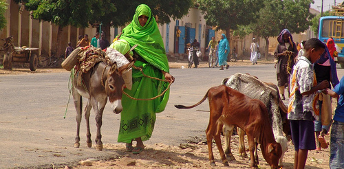
أگوردات
أگوردات
ኣቆርዳት Agordat, آكأوردات | |
|---|---|
بلدة | |
 | |
| الإحداثيات: 15°33′N 37°53′E / 15.550°N 37.883°E | |
| البلد | إرتريا |
| المنطقة | قاش-بركة |
| المنسوب | 2٬018 ft (615 m) |
| التعداد (2005) | |
| • الإجمالي | 30٬000 |
| منطقة التوقيت | UTC+3 (EAT) |
أگوردات (گعيز: ኣቆርዳት؛ أيضاً أكوردات و آكأوردات؛ إنگليزية: Agordat) هي مدينة في قاش-بركة، إرتريا. وكانت العاصمة السابقة للمقاطعة بركة السابقة، والتي كانت تقع بين منطقتي قاش-بركة وأنسبا.
. . . . . . . . . . . . . . . . . . . . . . . . . . . . . . . . . . . . . . . . . . . . . . . . . . . . . . . . . . . . . . . . . . . . . . . . . . . . . . . . . . . . . . . . . . . . . . . . . . . . . . . . . . . . . . . . . . . . . . . . . . . . . . . . . . . . . . . . . . . . . . . . . . . . . . . . . . . . . . . . . . . . . . . .
استعراض عام
تقع أگوردات في الجزء الغربي من البلد على نهر بركة. وهي بلدة سوق هامة، وتضم مسجداً جامعاً كبيراً.
الحفريات في أگوردات عثرت على خزف من حضارة المجموعة C ("تمهو") الرعوية، التي سكنت وادي النيل بين 2500-1500 ق.م.[1] كما عُثر على شظايا مشابهة لتلك من حضارة كرمة، وهي حضارة أخرى ازدهرت في وادي النيل في نفس الفترة، في مواقع أثرية قريبة في وادي بركة وتعود إلى مجموعة قاش.[2] وحسب پيتر بيرنز (1981) وماريان بشاوز-گرست (2000)، فإن الدليل اللغوي يشير إلى أن شعبي المجموعة C وكرمة كان يتكلمان لغات أفروآسيوية من الفرعين البربري والكوشي، بالترتيب.[3][4]
وكانت أگوردات آخر بلدة رئيسية على السكك الحديدية الإرترية إلى مصوع عبر أسمرة. ويواصل الخط إلى بيشيا محطته النهائية. ويعتمد الاقتصاد المحلي على التجار المتنقلين بين أسمرة وكسلا في السودان.
Agordat has many restaurants, as well as a hospital built during the colonial period في إرتريا الإيطالية. A considerable amount of Eritrea's fruit and vegetables, particularly bananas and oranges, are transported through the town. Additionally, the Akat fruit is grown locally.
المناخ
| Climate data for آكأوردات | |||||||||||||
|---|---|---|---|---|---|---|---|---|---|---|---|---|---|
| Month | Jan | Feb | Mar | Apr | May | Jun | Jul | Aug | Sep | Oct | Nov | Dec | Year |
| Mean daily maximum °C (°F) | 32 (89) |
33 (92) |
36 (96) |
39 (103) |
40 (104) |
37 (99) |
33 (91) |
32 (89) |
35 (95) |
37 (99) |
36 (96) |
33 (92) |
35 (95) |
| Mean daily minimum °C (°F) | 14 (58) |
14 (57) |
14 (58) |
18 (65) |
22 (72) |
22 (72) |
21 (69) |
21 (70) |
21 (69) |
21 (70) |
19 (67) |
16 (61) |
19 (66) |
| Average precipitation mm (inches) | 0 (0) |
0 (0) |
0 (0) |
0 (0) |
10 (0.4) |
30 (1.2) |
100 (3.9) |
140 (5.5) |
40 (1.6) |
0 (0) |
0 (0) |
0 (0) |
320 (12.6) |
| Source: Weatherbase [5] | |||||||||||||
صور
انظر أيضاً
الهامش
- ^ Cole, Sonia Mary (1964). The Prehistory of East. Weidenfeld & Nicolson. p. 273.
- ^ Leclant, Jean (1993). Sesto Congresso internazionale di egittologia: atti, Volume 2. International Association of Egyptologists. p. 402. Retrieved 15 September 2014.
- ^ Marianne Bechaus-Gerst, Roger Blench, Kevin MacDonald (ed.) (2014). The Origins and Development of African Livestock: Archaeology, Genetics, Linguistics and Ethnography - "Linguistic evidence for the prehistory of livestock in Sudan" (2000). Routledge. p. 453. ISBN 1135434166. Retrieved 15 September 2014.
{{cite book}}:|first1=has generic name (help)CS1 maint: multiple names: authors list (link) - ^ Behrens, Peter (1986). Libya Antiqua: Report and Papers of the Symposium Organized by Unesco in Paris, 16 to 18 January 1984 - "Language and migrations of the early Saharan cattle herders: the formation of the Berber branch". Unesco. p. 30. ISBN 9231023764. Retrieved 14 September 2014.
- ^ "Weatherbase: Historical Weather for Ak'ordat, Eritrea". Weatherbase. 2011. Retrieved on November 24, 2011.
15°33′N 37°53′E / 15.550°N 37.883°E
| هذا موقع في إرتريا article هو بذرة. بإمكانك مساعدة المعرفة بأن تنمـِّـيـه. |
- CS1 errors: generic name
- Pages using gadget WikiMiniAtlas
- Short description is different from Wikidata
- Articles containing Ge'ez-language text
- Articles containing إنگليزية-language text
- Pages using Lang-xx templates
- Coordinates on Wikidata
- منطقة قاش-بركة
- أماكن مأهولة في إرتريا
- All stub articles
- بذور جغرافيا إرتريا


