ملف:Westwall-ln-nl.jpg

حجم هذه المعاينة: 342 × 599 بكسل.
الملف الأصلي (800 × 1٬400 بكسل حجم الملف: 261 كيلوبايت، نوع MIME: image/jpeg)
وصف قصير
| ⧼wm-license-information-description⧽ |
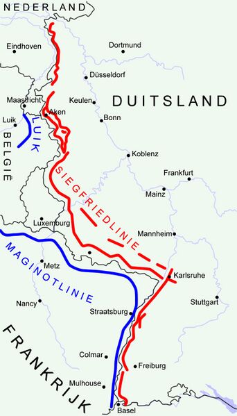
"Siegfried Line" (aka Westwall) (military defensive line) in Germany 1940 in red. "Maginotline" in blue. Disclaimer: The exact location of the lines may differ from reality to a slight extent. Made by Niels Bosboom. Based on map GNU FDL: Image:Karte westwall.png |
| ⧼wm-license-information-date⧽ | قالب:Original upload date |
| ⧼wm-license-information-source⧽ | No machine-readable source provided. Own work assumed (based on copyright claims). |
| ⧼wm-license-information-author⧽ | No machine-readable author provided. NielsB assumed (based on copyright claims). |
ترخيص
|
تاريخ الملف
اضغط على زمن/تاريخ لرؤية الملف كما بدا في هذا الزمن.
| زمن/تاريخ | صورة مصغرة | الأبعاد | مستخدم | تعليق | |
|---|---|---|---|---|---|
| حالي | ★ مراجعة معتمدة 23:21، 9 نوفمبر 2023 | | 800 × 1٬400 (261 كيلوبايت) | Pastakhov (نقاش | مساهمات) | Upload https://upload.wikimedia.org/wikipedia/commons/2/2a/Westwall-ln-nl.jpg |
لا يمكنك استبدال هذا الملف.
وصلات
لا يوجد صفحات تصل لهذه الصورة.