ملف:Waterberg SPOT 1369.jpg
لا توجد دقة أعلى متوفرة.
Waterberg_SPOT_1369.jpg (500 × 500 بكسل حجم الملف: 105 كيلوبايت، نوع MIME: image/jpeg)
وصف قصير
23°50′27″S 28°33′26″E / 23.84083°S 28.55722°E
| ⧼wm-license-information-description⧽ |
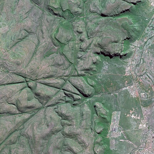
English: The northern Waterberg in the Limpopo province, photographed by the SPOT Satellite.
In view is Kgopung mountain, reaching to 1,437m a.s.l., and the upper reaches of the Mogalakwena river at 900m. The hights are included in the Moepel Nature Reserve. The settlements (from north to south) are Ga-Molekwa, Jakkalskuil, Mokerong, Kobeana, Nkgori, Schuurmanshoogte and Basterspad. |
| ⧼wm-license-information-date⧽ | 2006 |
| ⧼wm-license-information-source⧽ | http://gallery.spotimage.com/product_info.php?products_id=1369 |
| ⧼wm-license-information-author⧽ | Cnes - Spot Image Removed Watermark: (c) Cnes - Distribution Spot Image |
| ⧼wm-license-information-permission⧽ (⧼wm-license-information-permission-reusing-text⧽) |
ترخيص
|
تاريخ الملف
اضغط على زمن/تاريخ لرؤية الملف كما بدا في هذا الزمن.
| زمن/تاريخ | صورة مصغرة | الأبعاد | مستخدم | تعليق | |
|---|---|---|---|---|---|
| حالي | ★ مراجعة معتمدة 11:19، 6 نوفمبر 2023 | | 500 × 500 (105 كيلوبايت) | Pastakhov (نقاش | مساهمات) | Upload https://upload.wikimedia.org/wikipedia/commons/6/6c/Waterberg_SPOT_1369.jpg |
لا يمكنك استبدال هذا الملف.
وصلات
لا يوجد صفحات تصل لهذه الصورة.