ملف:Vette härad.svg

حجم معاينة PNG لذلك الملف ذي الامتداد SVG: 283 × 598 بكسل. البعد الآخر: 968 × 2٬048 بكسل.
الملف الأصلي (ملف SVG، أبعاده 7٬706 × 16٬296 بكسل، حجم الملف: 4٫61 ميجابايت)
| ⧼wm-license-information-description⧽ |
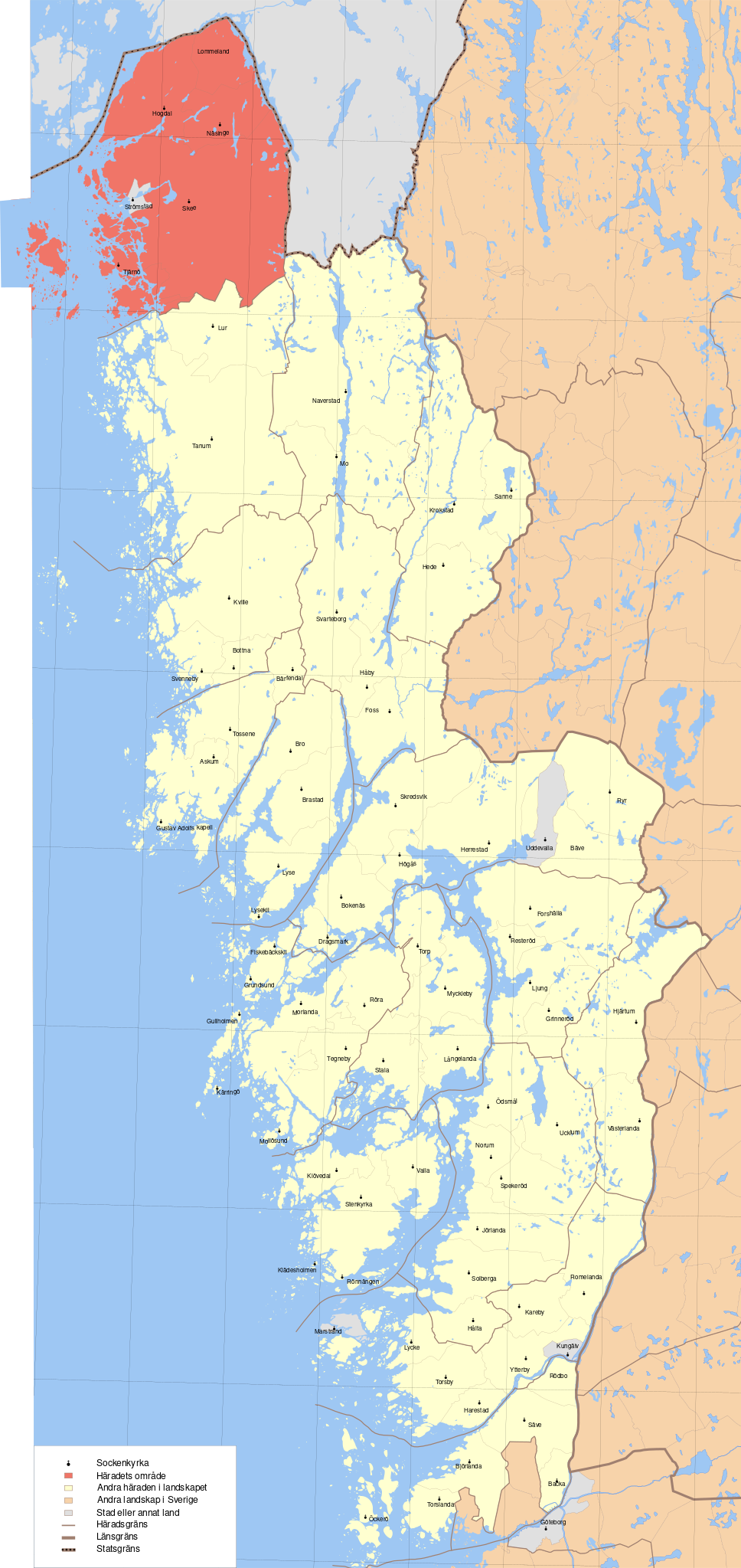
'English: Map showing borders of parishes and hundreds in the vicinity of Fjällbacka, based on information from map by Topografiska Corpsen. Fjellbacka Topografiska Corpsens Karta öfver Sverige 1843. Öfversedd 1858. English: Map showing borders of parishes and hundreds in the vicinity of Gothenburg, based on information from map by Topografiska Corpsen. 32. Göteborg Grav. af C. Schleich. Topografiska Corpsens karta öfver Sverige 1863. (Uppmätt 1838 och 1839, öfversedd 1862.) English: Map showing borders of parishes and hundreds in the vicinity of Gothenburg, based on information from map by Topografiska Corpsen. 33. Borås Topografiska Corpsens karta öfver Sverige 1869 (Upmätt åren 1836-37-39, öfversedt 1865) Geografiska längden är räknad från Stockholms Observatorium beläget 35 (grader)43'195 ost fr. Ferro. Höjdsiffrorna angifva höjd öfver hafvet i fot. Grav. af C. Schleich. English: Map showing borders of parishes and hundreds in the vicinity of Strömstad, based on information from map by Topografiska Corpsen. 61. Strömstad (med 60. Koster) Generalstabens karta öfver Sverige 1891. Uppmätt 1889. English: Map showing borders of parishes and hundreds in the vicinity of Uddevalla, based on information from map by Topografiska Corpsen. Uddevalla Topografiska Corpsens Karta öfver Sverige 1844. Öfversedd 1858. English: Map showing borders of parishes and hundreds in the vicinity of Upperud, based on information from map by Topografiska Corpsen. Upperud (Mellerud) Topografiska corpsens karta öfver Sverige 1845. Öfversedd 1858. English: Map showing borders of parishes and hundreds in the vicinity of Vänersborg, based on information from map by Topografiska Corpsen. Wenersborg Topografiska Corpsens karta öfver Sverige 1841. Öfversedd 1858. English: Map showing borders of parishes and hundreds in the vicinity of Åmål, based on information from map by Topografiska Corpsen. 62. Åmål Gravyren af Herlin. Generalstabens karta öfver Sverige 1894. Uppmätt 1891-92.
|
| ⧼wm-license-information-date⧽ | 2010-09-14 09:41 (UTC) |
| ⧼wm-license-information-source⧽ | |
| ⧼wm-license-information-author⧽ |
|
| [This is a retouched picture, which means that it has been digitally altered from its original version. Modifications: Marked the hundred of Västra Hising. The original can be viewed here: Bohuslän_landskap_härader_socknar.svg. Modifications made by Edaen.] Error: {{Lang}}: text has italic markup (help)
|
|
قالب:Original upload log
This image is a derivative work of the following images:
- File:Bohuslän_landskap_härader_socknar.svg licensed with Cc-by-sa-3.0
- 2010-09-14T09:33:03Z Edaen 7706x16296 (4880773 Bytes) {{Information |Description={{en|1=Map showing borders of parishes and hundreds in the vicinity of Fjällbacka, based on information from map by Topografiska Corpsen. '''Fjellbacka''' Topografiska Corpsens Karta öfver Sverig
تاريخ الملف
اضغط على زمن/تاريخ لرؤية الملف كما بدا في هذا الزمن.
| زمن/تاريخ | صورة مصغرة | الأبعاد | مستخدم | تعليق | |
|---|---|---|---|---|---|
| حالي | ★ مراجعة معتمدة 09:31، 5 نوفمبر 2023 | | 7٬706 × 16٬296 (4٫61 ميجابايت) | Pastakhov (نقاش | مساهمات) | Upload https://upload.wikimedia.org/wikipedia/commons/5/59/Vette_h%C3%A4rad.svg |
لا يمكنك استبدال هذا الملف.
وصلات
لا يوجد صفحات تصل لهذه الصورة.