ملف:Vanuatu-Hiw-Toponymic.png

حجم هذه المعاينة: 623 × 599 بكسل. البعد الآخر: 763 × 734 بكسل.
الملف الأصلي (763 × 734 بكسل حجم الملف: 94 كيلوبايت، نوع MIME: image/png)
وصف قصير
| ⧼wm-license-information-description⧽ |
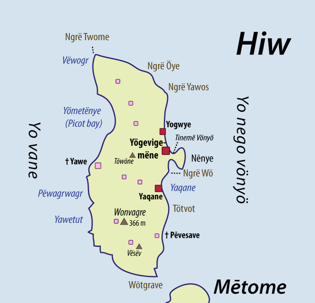
English: This map of Hiw (Torres Islands) shows some of the place names which are used by the local population, in Hiw. I have collected these place names while I was doing linguistic fieldwork in these islands. The spelling chosen here is a compromise between local phonologies/orthographies, and Western keyboards or usages. I would personally encourage the use of these transcriptions in further toponymic work on this area; except perhaps for the island names, which have been known under slightly different transcriptions in the literature. See Discussion page for further issues (spelling, etc). Red dots = inhabited villages; Pink dots = ancient villages, now deserted.
|
| ⧼wm-license-information-date⧽ | 2010 |
| ⧼wm-license-information-source⧽ | ⧼Wm-license-own-work⧽ |
| ⧼wm-license-information-author⧽ | Alexandre François |
| ⧼wm-license-information-other-versions⧽ |
File:Vanuatu-Torres-islands-Toponymic.png |
ترخيص
|

تاريخ الملف
اضغط على زمن/تاريخ لرؤية الملف كما بدا في هذا الزمن.
| زمن/تاريخ | صورة مصغرة | الأبعاد | مستخدم | تعليق | |
|---|---|---|---|---|---|
| حالي | ★ مراجعة معتمدة 21:28، 18 ديسمبر 2023 | | 763 × 734 (94 كيلوبايت) | Pastakhov (نقاش | مساهمات) | Upload https://upload.wikimedia.org/wikipedia/commons/6/60/Vanuatu-Hiw-Toponymic.png |
لا يمكنك استبدال هذا الملف.
وصلات
لا يوجد صفحات تصل لهذه الصورة.