ملف:USATopographicalMap.jpg

حجم هذه المعاينة: 800 × 527 بكسل. البعدان الآخران: 2٬560 × 1٬686 بكسل | 3٬199 × 2٬107 بكسل.
الملف الأصلي (3٬199 × 2٬107 بكسل حجم الملف: 11٫19 ميجابايت، نوع MIME: image/jpeg)
وصف قصير
| ⧼wm-license-information-description⧽ |
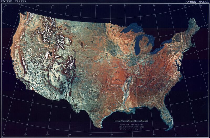
Deutsch: Satellitenbild der 48 Zentralstaaten der Vereinigten Staaten.
|
| ⧼wm-license-information-date⧽ | خطأ في التعبير: عامل < غير متوقع. |
| ⧼wm-license-information-source⧽ | National Climactic Data Center/NOAA Satellite and Information Service |
| ⧼wm-license-information-author⧽ | U.S. Dept. of Commerce/National Climactic Data Center/NOAA Satellite and Information Service |
ترخيص

|
تاريخ الملف
اضغط على زمن/تاريخ لرؤية الملف كما بدا في هذا الزمن.
| زمن/تاريخ | صورة مصغرة | الأبعاد | مستخدم | تعليق | |
|---|---|---|---|---|---|
| حالي | ★ مراجعة معتمدة 14:23، 23 أكتوبر 2023 | | 3٬199 × 2٬107 (11٫19 ميجابايت) | Pastakhov (نقاش | مساهمات) | Upload https://upload.wikimedia.org/wikipedia/commons/a/a0/USATopographicalMap.jpg |
لا يمكنك استبدال هذا الملف.
وصلات
لا يوجد صفحات تصل لهذه الصورة.