ملف:Topographic map of Jezero crater and surrounds (annotated) ESA23162625.png

حجم هذه المعاينة: 709 × 600 بكسل. البعدان الآخران: 2٬420 × 2٬048 بكسل | 26٬264 × 22٬223 بكسل.
الملف الأصلي (26٬264 × 22٬223 بكسل حجم الملف: 36٫2 ميجابايت، نوع MIME: image/png)
وصف قصير
| ⧼wm-license-information-description⧽ |
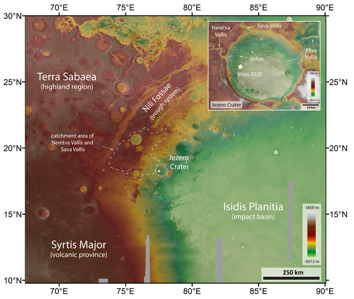
English: This elevation map of Jezero crater and its surrounds shows the topography of the broader region, from the highlands (red and browns) to the lower lying floor of the Isidis impact basin (green). The height difference in this area of 1.5 million square kilometres is over 6800 metres, with the floor of Jezero crater lying at an elevation of approximately minus 2600 metres below the ‘Mars Areoid’, a notional plane of equal gravitational attraction, analogous to sea level on Earth.
Jezero crater, the landing site of NASA’s 2020 Perseverance rover mission, is marked on the map. It hosts two river deltas from inflow channels that once brought water into Jezero, which is thought to have once hosted a lake. This elevation map was created from ESA Mars Express data. The High Resolution Stereo Camera’s nine sensors, arranged at right angles to the north-south flight direction, record the surface of Mars from different angles and in four colour channels. From the four inclined stereo channels and the nadir channel, which is directed perpendicular to the surface of Mars, scientists at the DLR Institute of Planetary Research and the Freie Universität Berlin compute digital terrain models, which assign elevation information to each pixel. The high resolution of the data processed for this image allows for greater enlargement of the images for a closer look at individual details of the landscape. Click here for a non-annotated version View download menu for high-res options. Find out more about Jezero crater and its surrounds, here. |
| ⧼wm-license-information-date⧽ | قالب:Upload date |
| ⧼wm-license-information-source⧽ | Topographic map of Jezero crater and surrounds (annotated) |
| ⧼wm-license-information-author⧽ | ESA/DLR/FU Berlin |
| ⧼wm-license-information-other-versions⧽ |
|
| Activity | Space Science |
| Mission | Mars Express |
ترخيص
تاريخ الملف
اضغط على زمن/تاريخ لرؤية الملف كما بدا في هذا الزمن.
| زمن/تاريخ | صورة مصغرة | الأبعاد | مستخدم | تعليق | |
|---|---|---|---|---|---|
| حالي | ★ مراجعة معتمدة 04:46، 7 نوفمبر 2023 | | 26٬264 × 22٬223 (36٫2 ميجابايت) | Pastakhov (نقاش | مساهمات) | Upload https://upload.wikimedia.org/wikipedia/commons/3/36/Topographic_map_of_Jezero_crater_and_surrounds_%28annotated%29_ESA23162625.png |
لا يمكنك استبدال هذا الملف.
وصلات
لا يوجد صفحات تصل لهذه الصورة.
_ESA23162625.png&oldid=3401735)