ملف:The Pool River in summer - geograph.org.uk - 841048.jpg
لا توجد دقة أعلى متوفرة.
The_Pool_River_in_summer_-_geograph.org.uk_-_841048.jpg (640 × 480 بكسل حجم الملف: 114 كيلوبايت، نوع MIME: image/jpeg)
وصف قصير
| ⧼wm-license-information-description⧽ |
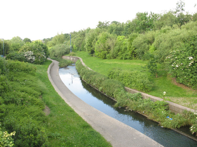
English: The Pool River in summer. The Pool River Linear park was created as part of the redevelopment of the Bell Green gas works site. The section of the river that ran in a culvert under the gas works has been diverted, opened up, land-scaped and now forms part of the Waterlink Way. Compare this view with 96626 taken in winter two-and-a-half years earlier.
|
| ⧼wm-license-information-date⧽ | 2008 |
| ⧼wm-license-information-source⧽ | From geograph.org.uk |
| ⧼wm-license-information-author⧽ | Stephen Craven |
| ⧼wm-license-cc-attribution⧽ (قالب:I18n/Credit line) |
Stephen Craven / The Pool River in summer / |
51°25′52″N 0°01′52″W / 51.43113°N 0.0311°W قالب:Object location
_heading:45)
ترخيص
تاريخ الملف
اضغط على زمن/تاريخ لرؤية الملف كما بدا في هذا الزمن.
| زمن/تاريخ | صورة مصغرة | الأبعاد | مستخدم | تعليق | |
|---|---|---|---|---|---|
| حالي | ★ مراجعة معتمدة 19:55، 3 نوفمبر 2023 | | 640 × 480 (114 كيلوبايت) | Pastakhov (نقاش | مساهمات) | Upload https://upload.wikimedia.org/wikipedia/commons/e/e2/The_Pool_River_in_summer_-_geograph.org.uk_-_841048.jpg |
لا يمكنك استبدال هذا الملف.
وصلات
لا يوجد صفحات تصل لهذه الصورة.