ملف:Territory governed by Braslav.png
لا توجد دقة أعلى متوفرة.
Territory_governed_by_Braslav.png (736 × 518 بكسل حجم الملف: 66 كيلوبايت، نوع MIME: image/png)
| ⧼wm-license-information-description⧽ |
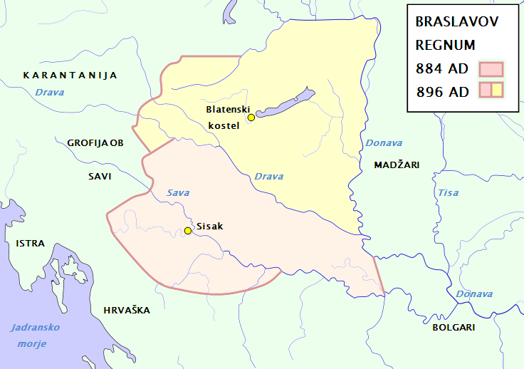
English: Regnum of Braslav: for northern borders of broadened regnum look at Inzko Valentin (1978): Zgodovina Slovencev do leta 1918. Mohorjeva založba, Celovec. Str. 34; Čepič Zdenko et al. (1979): Zgodovina Slovencev. Cankarjeva založba, Ljubljana 1979, str. 127 in 133; Peršič Janez et al. (1983): Stare kulture. Mladinska knjiga, Ljubljana, str. 144; for southern country look at Annales Fuldenses.
English: Waterways along the central and lower Danube, including the Bohemian and Carpathian Basins, the northern Balkans, parts of Austria, southern Poland and Western Ukraine.
|
| ⧼wm-license-information-date⧽ | 2010-05-27 21:12 (UTC) |
| ⧼wm-license-information-source⧽ | |
| ⧼wm-license-information-author⧽ |
|
| [This is a retouched picture, which means that it has been digitally altered from its original version. Modifications: Regnum of Braslav. The original can be viewed here: Waterways_of_SE_Central_Europe.svg. Modifications made by Bostjan46.] Error: {{Lang}}: text has italic markup (help)
|
قالب:Original upload log
This image is a derivative work of the following images:
- File:Waterways_of_SE_Central_Europe.svg licensed with PD-self
- 2010-01-08T20:49:27Z Kmiki87 1415x1059 (292577 Bytes) {{Information |Description={{en|1=Waterways along the central and lower Danube, including the Bohemian and Carpathian Basins, the northern Balkans, parts of Austria, southern Poland and Western Ukraine.}} |Source={{own}} |Aut
تاريخ الملف
اضغط على زمن/تاريخ لرؤية الملف كما بدا في هذا الزمن.
| زمن/تاريخ | صورة مصغرة | الأبعاد | مستخدم | تعليق | |
|---|---|---|---|---|---|
| حالي | ★ مراجعة معتمدة 02:57، 19 ديسمبر 2023 | | 736 × 518 (66 كيلوبايت) | Pastakhov (نقاش | مساهمات) | Upload https://upload.wikimedia.org/wikipedia/commons/1/16/Territory_governed_by_Braslav.png |
لا يمكنك استبدال هذا الملف.
وصلات
لا يوجد صفحات تصل لهذه الصورة.