ملف:Territorial waters - UK - USA - AUS.svg

حجم معاينة PNG لذلك الملف ذي الامتداد SVG: 800 × 400 بكسل. البعد الآخر: 2٬560 × 1٬280 بكسل.
الملف الأصلي (ملف SVG، أبعاده 800 × 400 بكسل، حجم الملف: 736 كيلوبايت)
وصف قصير
| ⧼wm-license-information-description⧽ |
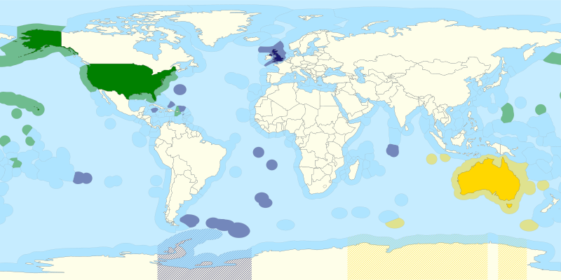
English: Original SVG by User:B1mbo - File:Territorial waters - World.svg, CC BY-SA 3.0 cl, https://commons.wikimedia.org/w/index.php?curid=17195294
Altered to depict Britain, the United States, and Australia, along with their territorial and Antarctic claims. This was done through the merger of the existing map of British Territorial Waters with the existing map Australian territorial waters, and then the colouring of the American waters. The following SVG element ID's were used to do this: path4401 - US territorial waters path5204, path4656, path8100, path4046, path3229 - UK territorial waters path4934 - Australian territorial waters The Antarctic claims are represented by structures added just before the "Countries" section, and at the very end of the document. The countries themselves are named "USA" for the United States, "Australie" for Australia, and "Royaume Uni" for the United Kingdom. |
| ⧼wm-license-information-date⧽ | 2021 |
| ⧼wm-license-information-source⧽ | Own work(?), based on File:Territorial waters - World.svg |
| ⧼wm-license-information-author⧽ | BilledMammal |
| ⧼wm-license-information-other-versions⧽ |
ترخيص
|
تاريخ الملف
اضغط على زمن/تاريخ لرؤية الملف كما بدا في هذا الزمن.
| زمن/تاريخ | صورة مصغرة | الأبعاد | مستخدم | تعليق | |
|---|---|---|---|---|---|
| حالي | ★ مراجعة معتمدة 22:26، 17 نوفمبر 2023 | | 800 × 400 (736 كيلوبايت) | Pastakhov (نقاش | مساهمات) | Upload https://upload.wikimedia.org/wikipedia/commons/4/4e/Territorial_waters_-_UK_-_USA_-_AUS.svg |
لا يمكنك استبدال هذا الملف.
وصلات
لا يوجد صفحات تصل لهذه الصورة.