ملف:Stura di valgrande location map.jpg

حجم هذه المعاينة: 800 × 492 بكسل. البعد الآخر: 961 × 591 بكسل.
الملف الأصلي (961 × 591 بكسل حجم الملف: 284 كيلوبايت، نوع MIME: image/jpeg)
وصف قصير
| ⧼wm-license-information-description⧽ |
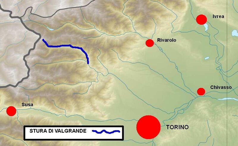
Italiano: Posizione del torrente nella provincia di Torino English: Stura di Valgrande position within Turin province (NW Italy)
|
| ⧼wm-license-information-date⧽ | 2013, {{time}} – invalid date format 30 (help) |
| ⧼wm-license-information-source⧽ | ⧼Wm-license-own-work⧽ |
| ⧼wm-license-information-author⧽ | F Ceragioli |
| [This is a retouched picture, which means that it has been digitally altered from its original version. Modifications: Added river position. The original can be viewed here: Piemonte_relief_location_map.jpg. Modifications made by F_Ceragioli.] Error: {{Lang}}: text has italic markup (help)
|
ترخيص
|
تاريخ الملف
اضغط على زمن/تاريخ لرؤية الملف كما بدا في هذا الزمن.
| زمن/تاريخ | صورة مصغرة | الأبعاد | مستخدم | تعليق | |
|---|---|---|---|---|---|
| حالي | ★ مراجعة معتمدة 10:57، 3 ديسمبر 2023 | | 961 × 591 (284 كيلوبايت) | Pastakhov (نقاش | مساهمات) | Upload https://upload.wikimedia.org/wikipedia/commons/3/3e/Stura_di_valgrande_location_map.jpg |
لا يمكنك استبدال هذا الملف.
وصلات
لا يوجد صفحات تصل لهذه الصورة.