ملف:Steinheim Basin.jpg
حجم هذه المعاينة: 800 × 117 بكسل. البعد الآخر: 2٬445 × 357 بكسل.
الملف الأصلي (2٬445 × 357 بكسل حجم الملف: 174 كيلوبايت، نوع MIME: image/jpeg)
| ⧼wm-license-information-description⧽ |
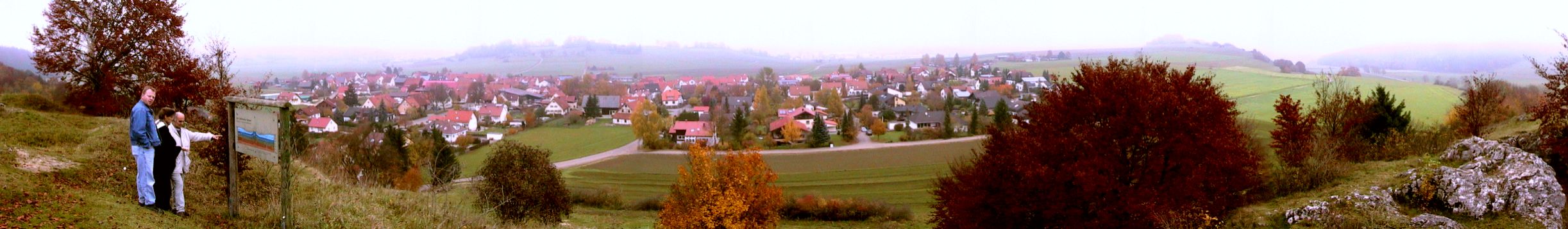
English: Panoramic view of the Steinheim Basin, as seen from the southern crater rim ("Burgstall"). Sontheim, part of the village of Steinheim, is located on the crater floor in the foreground. Visible behind the village is the "Steinhirt", which forms the cenral uplift of the crater. To the right, behind the bush with the dark red leaves, the southeastern rim ("Knill") is visible, and at far right, the "Stubental" valley is visible, which runs south of the crater. In the far backround, at both sides of the Steinhirt, the northern crater rim is also visible.
Deutsch: Panoramaaufnahme des Steinheimer Beckens, aufgenommen vom südlichen Kraterwall (Burgstall). Am Kraterboden im Vordergrund befindet sich der Steinheimer Ortsteil Sontheim, dahinter ist der Steinhirt zu sehen, der den Zentralberg des Kraters darstellt. Rechts, hinter dem Strauch mit dem dunkelroten Laub, ist der südöstliche Kraterwall (Knill) zu sehen, und ganz rechts das Stubental, das südlich am Krater vorbeiläuft. Im Hintergrund lässt sich auf beiden Seiten des Steinhirts auch noch der nördliche Kraterrand zu erkennen.
|
| ⧼wm-license-information-date⧽ | 2005 |
| ⧼wm-license-information-source⧽ | ⧼Wm-license-own-work⧽ |
| ⧼wm-license-information-author⧽ | H. Raab (User:Vesta) |
48°40′29.3″N 10°4′8.8″E / 48.674806°N 10.069111°E
|

تاريخ الملف
اضغط على زمن/تاريخ لرؤية الملف كما بدا في هذا الزمن.
| زمن/تاريخ | صورة مصغرة | الأبعاد | مستخدم | تعليق | |
|---|---|---|---|---|---|
| حالي | ★ مراجعة معتمدة 13:01، 8 نوفمبر 2023 | 2٬445 × 357 (174 كيلوبايت) | Pastakhov (نقاش | مساهمات) | Upload https://upload.wikimedia.org/wikipedia/commons/0/0a/Steinheim_Basin.jpg |
لا يمكنك استبدال هذا الملف.
وصلات
لا يوجد صفحات تصل لهذه الصورة.