ملف:St Patrick's, Glenarm - geograph.org.uk - 324890.jpg
لا توجد دقة أعلى متوفرة.
St_Patrick's,_Glenarm_-_geograph.org.uk_-_324890.jpg (640 × 426 بكسل حجم الملف: 170 كيلوبايت، نوع MIME: image/jpeg)
وصف قصير
| ⧼wm-license-information-description⧽ |
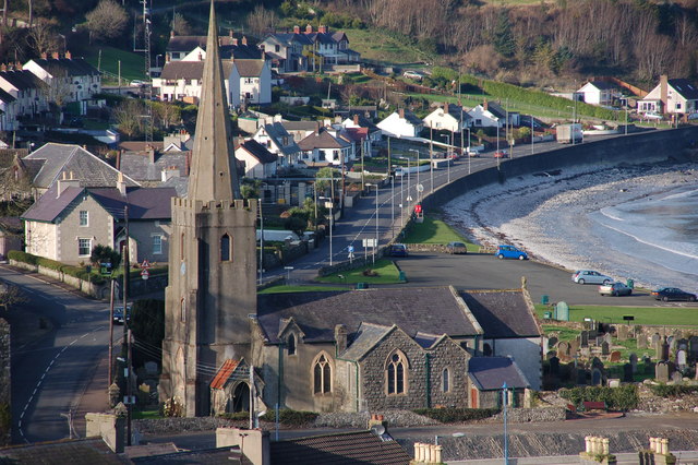
English: St Patrick's, Glenarm St Patricks, Glenarm, in the parish of Tickmacrevan, was built in 1769 on the site of a former friary. It was extended in 1823, 1878 and 1892. The adjacent public car park does not enhance an otherwise attractive site. Photo from the Dickeystown Road (in the same square).
|
| ⧼wm-license-information-date⧽ | 2007 |
| ⧼wm-license-information-source⧽ | From geograph.org.uk |
| ⧼wm-license-information-author⧽ | Albert Bridge |
| ⧼wm-license-cc-attribution⧽ (قالب:I18n/Credit line) |
Albert Bridge / St Patrick's, Glenarm / |
ترخيص
تاريخ الملف
اضغط على زمن/تاريخ لرؤية الملف كما بدا في هذا الزمن.
| زمن/تاريخ | صورة مصغرة | الأبعاد | مستخدم | تعليق | |
|---|---|---|---|---|---|
| حالي | ★ مراجعة معتمدة 14:50، 26 يناير 2024 | | 640 × 426 (170 كيلوبايت) | Pastakhov (نقاش | مساهمات) | Upload https://upload.wikimedia.org/wikipedia/commons/1/12/St_Patrick%27s%2C_Glenarm_-_geograph.org.uk_-_324890.jpg |
لا يمكنك استبدال هذا الملف.
وصلات
لا يوجد صفحات تصل لهذه الصورة.