ملف:St. Xavier High School (Cincinnati), 2005 aerial.tiff

حجم معاينة PNG لذلك الملف ذي الامتداد TIF: 265 × 599 بكسل.
الملف الأصلي (2٬207 × 4٬991 بكسل حجم الملف: 31٫6 ميجابايت، نوع MIME: image/tiff)
وصف قصير
| ⧼wm-license-information-description⧽ |
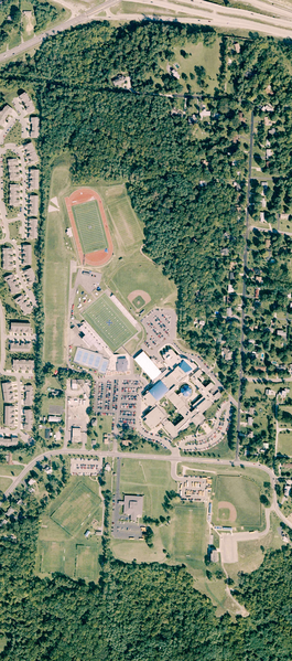
English: Natural color DOQQ photograph of St. Xavier High School in Cincinnati, Ohio, taken sometime between August 24 and October 15, 2005. Visible at the top is Ronald Reagan Cross County Highway at the Winton Road exit. This orthophoto includes the 2003 renovation of St. Xavier Stadium and 2005 addition of the Performance Center and is up-to-date as of 2009.
|
| ⧼wm-license-information-date⧽ | 2007 |
| ⧼wm-license-information-source⧽ | USGS High Resolution Orthoimagery for the Cincinnati, Ohio/Northern Kentucky Urban Area. Sioux Falls: United States Geological Survey. 2007. As reproduced in "The National Map Seamless Server Viewer". The National Map Seamless Server. USGS Center for Earth Resources Observation and Science. |
| ⧼wm-license-information-author⧽ | United States Geological Survey |
| ⧼wm-license-information-other-versions⧽ |
,_2000_aerial.jpg)
39°13′24.35″N 84°30′44.84″W / 39.2234306°N 84.5124556°W
ترخيص
تاريخ الملف
اضغط على زمن/تاريخ لرؤية الملف كما بدا في هذا الزمن.
| زمن/تاريخ | صورة مصغرة | الأبعاد | مستخدم | تعليق | |
|---|---|---|---|---|---|
| حالي | ★ مراجعة معتمدة 06:25، 14 أكتوبر 2023 |  | 2٬207 × 4٬991 (31٫6 ميجابايت) | Pastakhov (نقاش | مساهمات) | Upload https://upload.wikimedia.org/wikipedia/commons/0/0f/St._Xavier_High_School_%28Cincinnati%29%2C_2005_aerial.tiff |
لا يمكنك استبدال هذا الملف.
وصلات
لا يوجد صفحات تصل لهذه الصورة.