ملف:St. Mary's church, Fryerning - geograph.org.uk - 340854.jpg
لا توجد دقة أعلى متوفرة.
St._Mary's_church,_Fryerning_-_geograph.org.uk_-_340854.jpg (640 × 445 بكسل حجم الملف: 104 كيلوبايت، نوع MIME: image/jpeg)
وصف قصير
| ⧼wm-license-information-description⧽ |
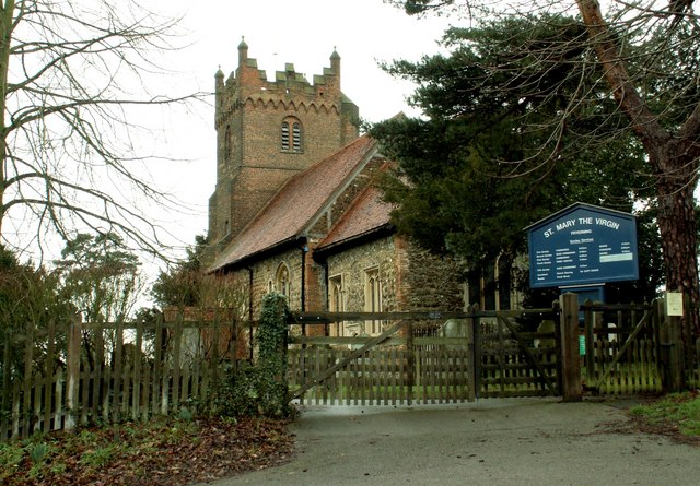
English: St. Mary's church, Fryerning This small church dates back to Norman times and the exterior of the nave and chancel shows that many Roman bricks were re-used in its construction. The splendid brick tower, with its blue brick diapering, is early 16th century. قالب:Listed building England
|
| ⧼wm-license-information-date⧽ | 2007 |
| ⧼wm-license-information-source⧽ | From geograph.org.uk |
| ⧼wm-license-information-author⧽ | Robert Edwards |
| ⧼wm-license-cc-attribution⧽ (قالب:I18n/Credit line) |
Robert Edwards / St. Mary's church, Fryerning / |
51°40′33″N 0°22′07″E / 51.67572°N 0.3687°E قالب:Object location
_heading:292)
ترخيص
تاريخ الملف
اضغط على زمن/تاريخ لرؤية الملف كما بدا في هذا الزمن.
| زمن/تاريخ | صورة مصغرة | الأبعاد | مستخدم | تعليق | |
|---|---|---|---|---|---|
| حالي | ★ مراجعة معتمدة 07:28، 9 نوفمبر 2023 | | 640 × 445 (104 كيلوبايت) | Pastakhov (نقاش | مساهمات) | Upload https://upload.wikimedia.org/wikipedia/commons/0/0e/St._Mary%27s_church%2C_Fryerning_-_geograph.org.uk_-_340854.jpg |
لا يمكنك استبدال هذا الملف.
وصلات
لا يوجد صفحات تصل لهذه الصورة.